Housing incentives are not just policy. They are financing tools. In affordable housing, location directly controls financing.
If you’ve spent any time in development, you’ve heard the terms QCT, DDA, and LIHTC. They come up in underwriting, capital stack discussions, and HUD maps. But even though they’re used all the time, many developers don’t fully connect what they actually mean in practice.
Here’s the reality. Two parcels that look identical can produce completely different financial outcomes. Not because of design, demand, or construction quality, but because of where they sit relative to invisible federal boundaries. That difference can directly impact how much investor equity your project can raise.
This guide breaks it down in simple, practical terms.
1. Start with One Thing: The Census Tract
Everything starts here.
A census tract is a small geographic area defined by the U.S. Census Bureau, typically covering 2,000 to 8,000 people. These boundaries were created for data collection, not real estate, but today they play a critical role in how affordable housing gets financed.
HUD uses census tracts to determine where incentives apply. That means your project’s exact tract determines whether you qualify for additional tax credits.
Think of it simply: Country → City → Census tract
Your project sits on one “page,” and that page determines your financial potential.
2. The System in One View
These three concepts are not separate. They work together as one system.
LIHTC is the engine. The Low-Income Housing Tax Credit is the federal program that generates capital for affordable housing. Developers receive tax credits, sell them to investors, and use that equity to fund construction.
QCT is the low-income trigger. A Qualified Census Tract is a lower-income area designated by HUD. Projects located here may qualify for up to a 30% increase in eligible basis, which means more tax credits.
DDA is the high-cost trigger. A Difficult Development Area is a place where development costs are high relative to income. Projects here may also qualify for up to a 30% basis boost to help offset those costs.
Simple takeaway: LIHTC generates the capital, while QCT and DDA determine how much capital your project can unlock.
3. What LIHTC Actually Does
LIHTC, created under Internal Revenue Code Section 42, is the main tool used to finance affordable rental housing in the United States.
In practice, developers receive tax credits in exchange for setting aside units for low-income tenants at restricted rents. Those credits are then sold to investors — typically banks or large institutions — who use them to reduce their federal tax liability. That sale generates equity for the project.
More credits = more equity. More equity = less debt. Less debt = better feasibility.
In simple terms, you earn tax credits by building affordable housing, sell them, and use the cash to fund your project.
4. How the Credits Scale
The amount of tax credits your project generates is based on eligible basis, which includes most development costs but excludes land. This number drives the entire calculation.
Here’s where QCT and DDA become critical. If your project is located in one of these designated areas, your eligible basis can increase up to 130%. That means a bigger starting number, which leads to more credits and more investor equity.
For example, a project with a $10 million eligible basis becomes $13 million with the boost. The building hasn’t changed, but the financing has.
5. What Is a Qualified Census Tract (QCT)?
A QCT is a census tract designated by HUD as lower-income. A tract qualifies if at least 50% of households earn 60% or less of Area Median Income, or if the poverty rate is 25% or higher.
HUD updates these designations annually using Census data. There is also a cap — only up to 20% of a metro area’s population can be included in QCTs, meaning not every qualifying tract is selected.
For developers, the impact is direct. If your project is inside a QCT, you may qualify for up to a 30% basis boost, increasing the total tax credits and equity available.
6. What Is a Difficult Development Area (DDA)?
A DDA is a location where development is more difficult because costs are high relative to local incomes. HUD identifies these areas by comparing housing costs to income levels and selecting the places where the gap is the largest.
These are often high-cost markets where construction is expensive but rents are still limited by affordability requirements.
For developers, DDAs solve this imbalance. They provide up to a 30% basis boost, increasing tax credits and helping make projects financially viable in places where they otherwise might not work.
7. Why Parcel-Level Detail Changes Everything
In affordable housing, incentives operate at a very precise level. Even small shifts in location can materially change outcomes. A parcel that falls just inside a boundary may qualify for significantly more financing, while a parcel just outside may not qualify at all.
That difference directly affects project scale, unit count, and overall feasibility. This is why location is no longer just a planning factor. It is a financial driver, and feasibility is directly tied to exact boundaries and designations.
The Boundary Problem
This is where many deals go wrong. Two sites on the same street can fall into different census tracts or boundary zones — where one qualifies for additional tax credits and the other does not. That difference can create a major gap in investor equity.
These boundaries do not follow streets or neighborhoods. They follow statistical lines that are not visible unless you map them, and they change every year — which makes assumptions risky and verification essential.
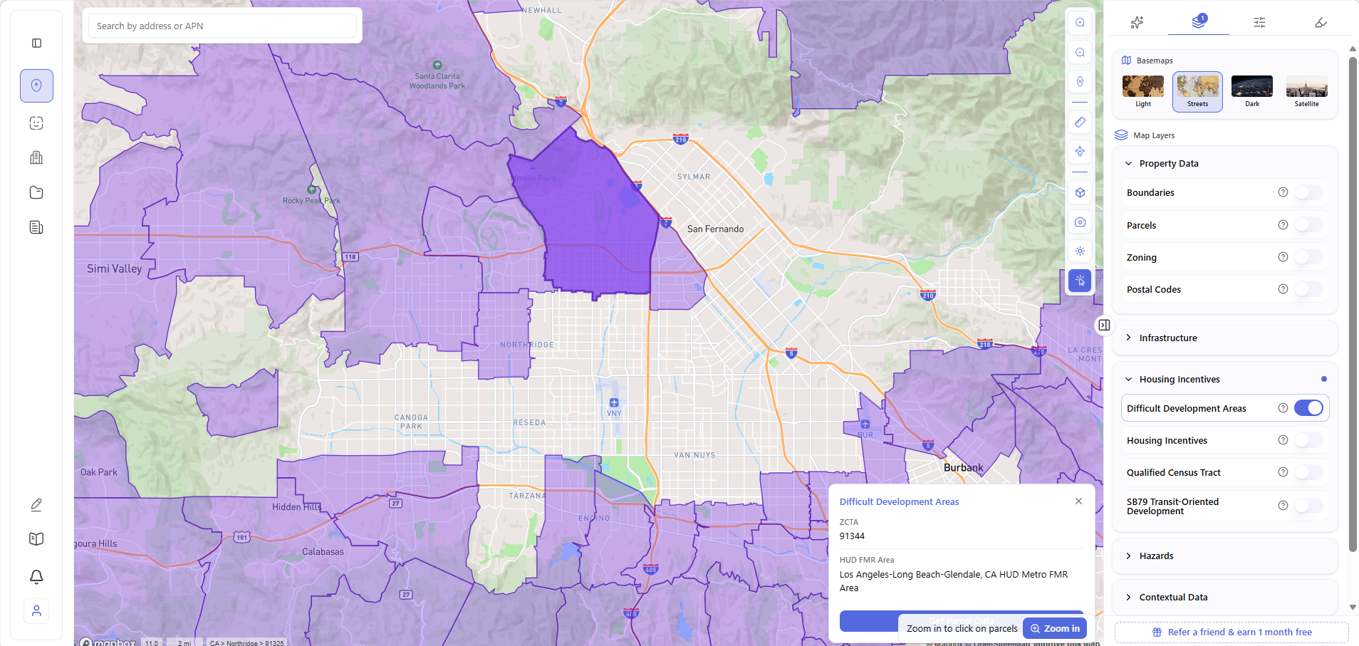
8. How This Appears in ArchiWise
Understanding incentives is one thing. Seeing them on real parcels is what makes them useful. In Archiwise.ai, QCT and DDA are available as part of the Housing Incentives layer, mapped directly onto parcels.
At the city level, you can see full QCT boundaries as census tract overlays.

You can also turn on the DDA layer to view high-cost areas defined by HUD.

At the parcel level, the value becomes immediate: click any parcel and the info modal surfaces whether it falls within a QCT, a DDA, LIHTC eligibility, or any combination of the three — no external lookups required. It turns an invisible federal boundary into a visible, actionable development signal at the moment you need it.

The Final Takeaway
LIHTC is the engine behind affordable housing.
QCT and DDA determine how powerful that engine becomes.
And everything comes down to one thing: exact location.
A project does not change, but its financing can change significantly depending on whether it falls inside the right boundary. Understanding that is what separates a site that works from one that does not.
Ready to Take Action?
Find Financing Potential in Seconds.
With Archiwise, you can instantly visualize eligibility zones and uncover financing potential before you commit to a deal.
Learn More
ArchiWise helps developers, investors, architects, and brokers move beyond policy theory and into parcel-level reality.
Whether evaluating land for affordable housing, mixed-income projects, or adaptive reuse, ArchiWise surfaces financing signals — QCT, DDA, LIHTC — before time and capital are committed.
Explore how ArchiWise helps teams analyze real sites and make smarter development decisions.