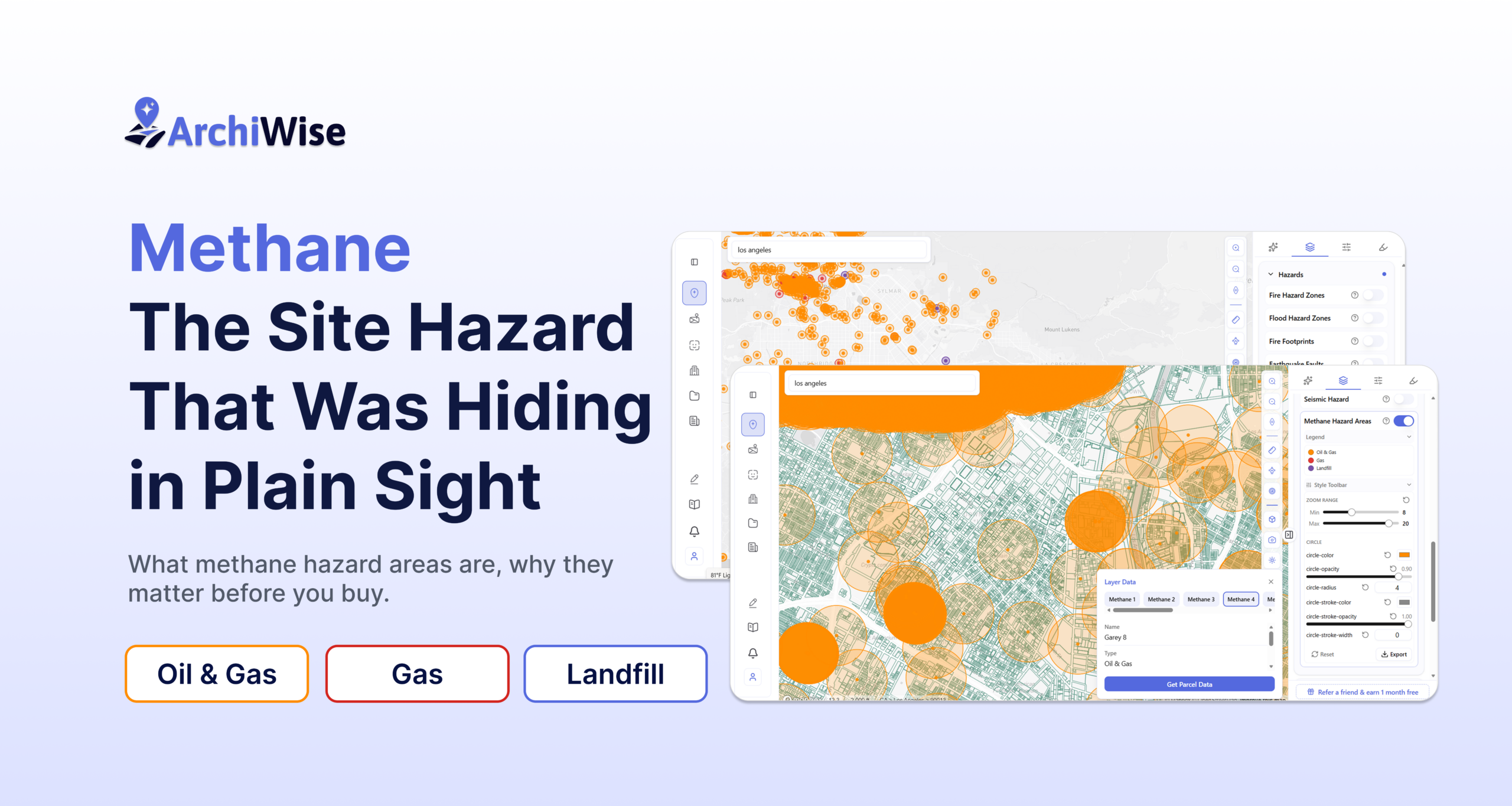
Methane: The Site Hazard That Was Hiding in Plain Sight
What methane hazard areas are, why they matter before you buy, and how to find them in minutes
You’ve done the zoning research. The numbers pencil. The site is in a strong infill location with good fundamentals. Two weeks before closing, your environmental consultant calls.
The site is in a methane hazard area.
The foundation design needs to change. The slab requires a barrier system. The mechanical engineer has to revisit ventilation. The construction budget changes. The schedule slips.
None of this was in the listing. None of it showed up in the zoning code. And none of it was hard to find – if you’d known where to look.
Methane is the hazard that surprises developers most. Not because it’s rare, but because it’s invisible in most of the tools people use for site research. It doesn’t appear in a zoning report. A title search won’t flag it. And unlike flood zones – which lenders catch automatically – methane designation is something you have to go looking for.
What Methane Actually Is
Methane is a colorless, odorless gas. It forms naturally when organic material decomposes underground, and as a byproduct of oil and gas extraction. It migrates through soil and rock fractures – slowly, over time, upward – toward the surface and into whatever sits above it.
In open air it disperses harmlessly. The problem is what happens when it can’t. In crawl spaces, underground parking structures, elevator pits, and mechanical rooms, methane accumulates. At 5–15% concentration in air it becomes flammable. Below that threshold it displaces oxygen – an asphyxiation risk in confined spaces.
The hazard isn’t dramatic or sudden. It’s a slow migration from a source that may be a hundred years old, through soil nobody has thought about since the well was drilled, into structures built long after the original activity ended. That’s what makes it easy to miss – and expensive to discover late.
Three Sources to Know
Methane hazard areas come from three types of emission sources. Each behaves differently and carries different implications for a development site.
Oil and gas wells
The most widespread source of methane hazard in urban America. Active wells, idle wells, and abandoned wells – including wells drilled in the early 20th century that have no surface markers, no visible infrastructure, and often no easy-to-find records.
In Los Angeles, oil extraction was active in what are now dense urban neighbourhoods. Culver City, Inglewood, Downtown, Beverly Hills – wells were drilled here when these were open fields. The fields are long gone. The wells remain. Some are properly capped. Some are not. Hundreds of these sources now sit underneath residential streets, office buildings, and active development sites with no surface indication of what’s below.
Gas wells
Dedicated natural gas production wells present a similar migration risk, often with higher methane concentrations at source. Casing integrity and well age are the key variables. An older well with degraded casing in a developed area carries more risk than a newer, properly maintained well in an open field.
Landfills
Decomposing organic waste generates methane continuously – and this doesn’t stop when a landfill closes. It continues for decades after operations end. A parcel adjacent to a landfill that closed in 1985 may still have active methane migration beneath it today.
Unlike a well, a landfill isn’t a single point source. It’s an area – sometimes dozens of acres – where methane is generated across the entire footprint and migrates outward in multiple directions. The hazard zone extends well beyond the physical boundary of the landfill itself. Beyond methane, a site adjacent to a landfill also carries ground settlement risk and potential leachate contamination – compounding the development challenge.
What It Costs If You Miss It
The construction requirements triggered by a methane designation are not optional. In Los Angeles, methane zone construction requirements are codified in Chapter 71 of the LAMC. Other jurisdictions handle it through environmental review or conditional permits.
The mitigation approach depends on the designation and the specific source characteristics – passive barrier membranes beneath the slab, venting systems, active monitoring in higher-hazard areas. These are engineered systems that affect structural drawings, foundation design, and plan check review. They add meaningful cost and time regardless of where you are in the project.
If you discover the designation after your construction documents are 80% complete, you’re looking at a redesign cycle. If you discover it after you close, the conversation is different entirely. The developer who finds a methane designation in pre-development has options. The one who finds it in plan check does not.
How Archiwise Built This Layer
Architects and development teams kept hitting the same problem during site evaluations: methane hazard data was scattered across different sources. Oil well records in one database. Landfill locations somewhere else. Buffer zones buried in city PDFs or jurisdiction-specific portals, different for every city they worked in.
Every time a site was assessed, someone was cross-referencing multiple systems to piece together a complete picture for a single parcel.
The team at Archiwise heard this directly from the firms using the platform. The methane layer shipped in a week – not a feature request into a backlog, but a fast response to a real workflow problem raised by real users. It’s now a standard part of site evaluation for the teams that use it.
The Layer, In Practice
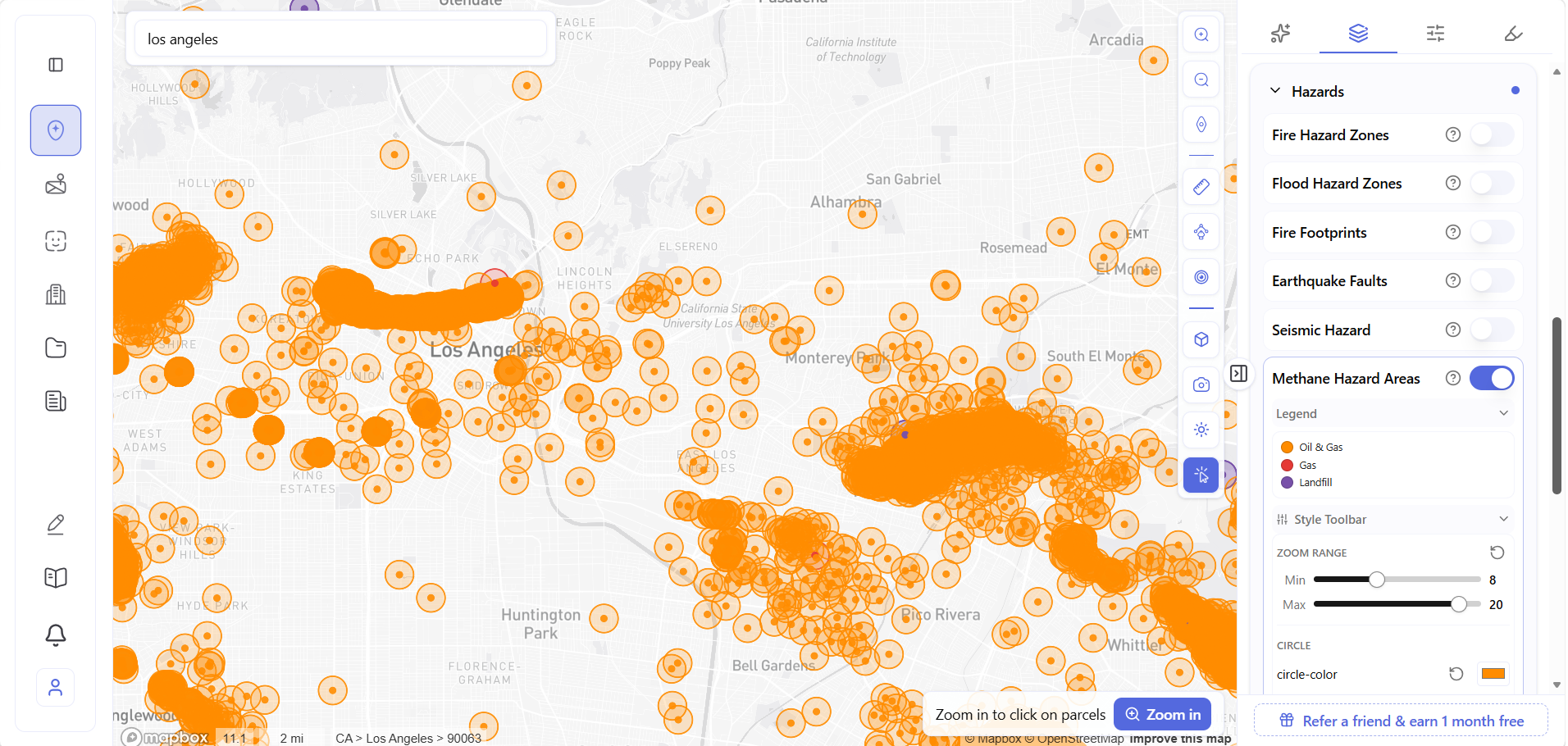
Toggle on Methane Hazard Areas under Layers → Hazards. The map populates with emission source circles color-coded by type – orange for oil and gas wells, red for gas wells, purple for landfills – each shown with a ½ mile buffer zone representing the potential hazard area around it.
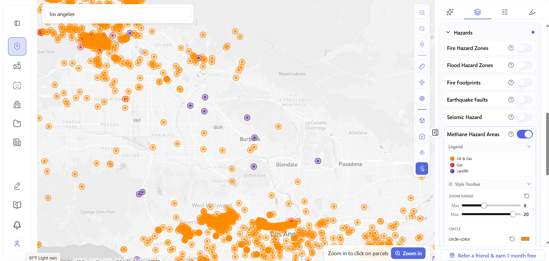
The density of what you’re looking at is not coincidental. The LA Basin was one of the most actively drilled urban oil regions in American history. Hundreds of wells were sunk into what are now fully developed neighbourhoods, many of them decades before the structures above them existed. The layer makes that history visible – and actionable.
What Overlapping Sources Mean
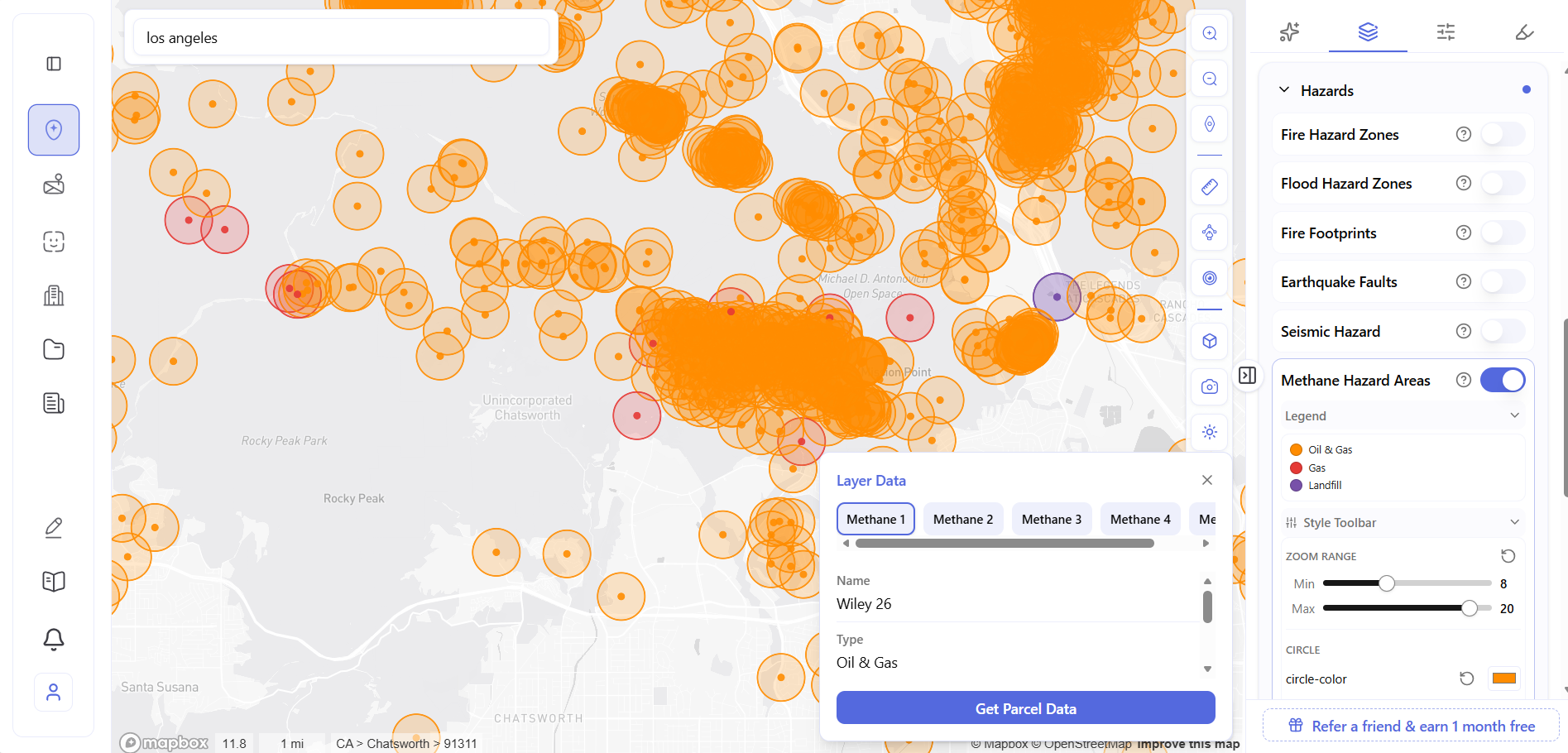
Here’s the detail that becomes clear once you start using the layer: sources overlap.
Each emission source has a ½ mile buffer zone. In areas with dense extraction history – like downtown Los Angeles – multiple buffer zones cover the same blocks simultaneously. Click a point in that overlap and the popup shows multiple tabs, each representing a separate source whose buffer reaches that location: Methane 1, Methane 2, Methane 3, Methane 4, and more.
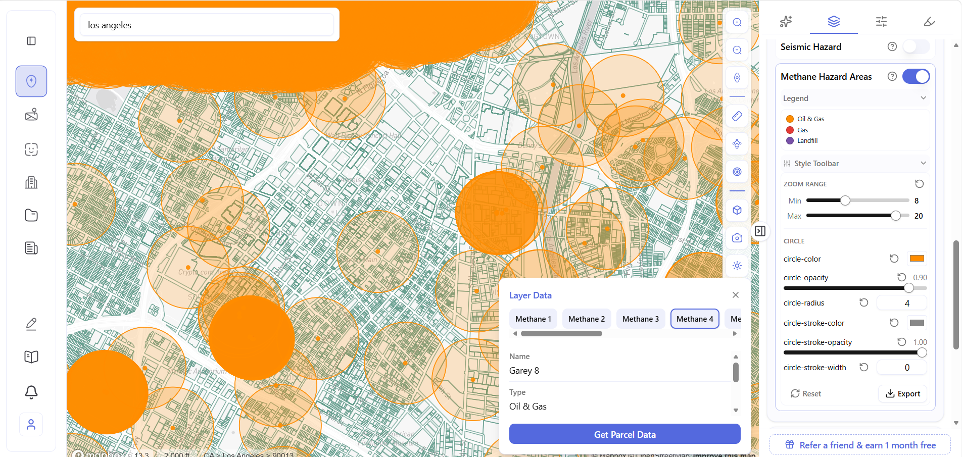
The Garey 8 well is one of four separate sources overlapping at that single click point – each with its own ½ mile buffer covering the same city blocks. A developer evaluating a site in that overlap is working with cumulative hazard from multiple sources simultaneously, not a single well. More overlapping sources means more cumulative migration potential – the kind of detail that doesn’t surface anywhere else in a pre-development workflow.
Landfills Are Different
Oil and gas wells are point sources. A landfill is an area. The methane migration zone around a landfill extends in multiple directions across its entire footprint – and as a live, operating facility, it continues generating methane around the clock. 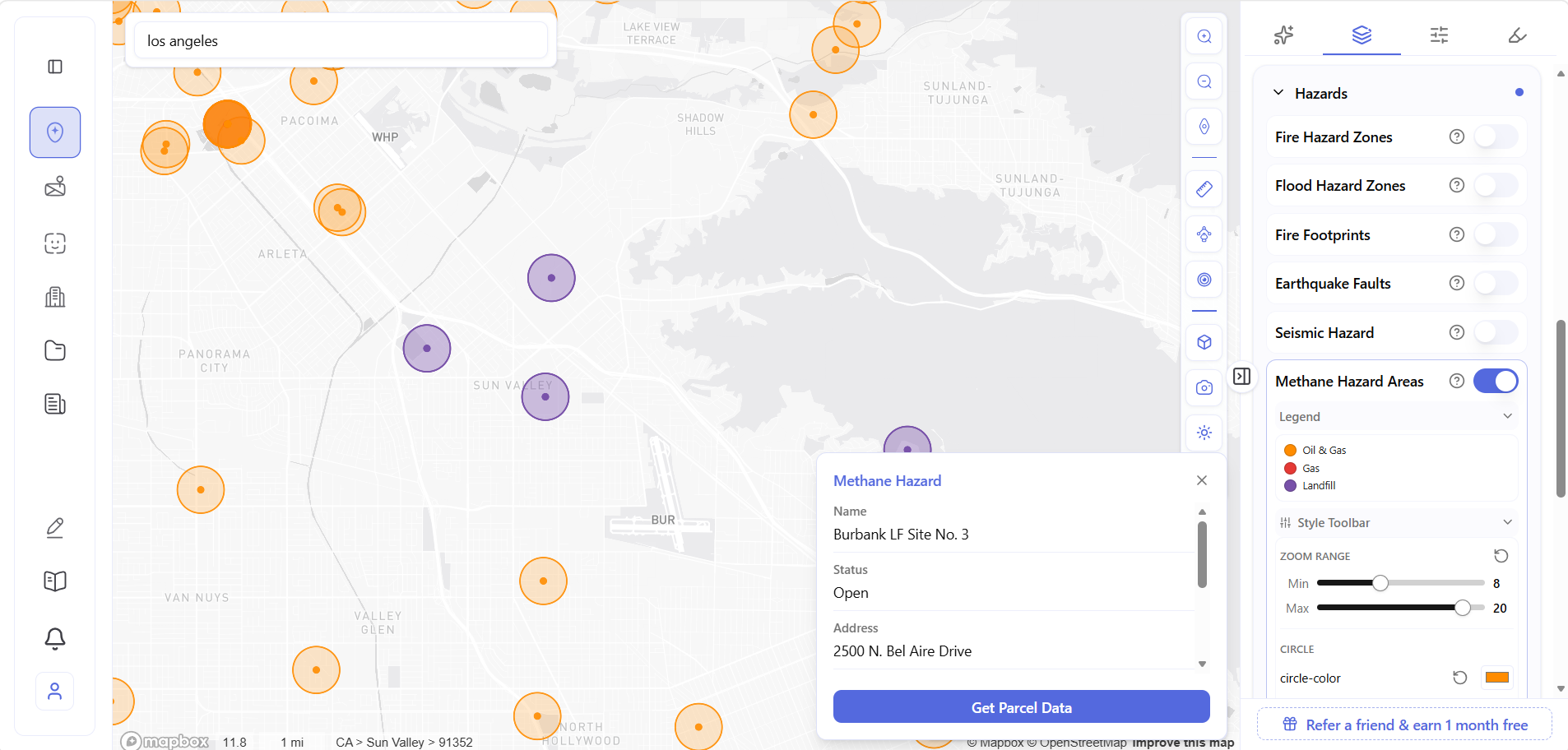
The Burbank LF Site No. 3 at 2500 N. Bel Aire Drive is an open, active landfill – visible on the layer as a purple circle in a residential and light industrial corridor. Any parcel within its ½ mile buffer is within potential methane migration range of an active waste facility. That’s not just a construction cost issue – it’s an asset value and insurability consideration that affects the project for its entire life.
Click the Source. Get the Parcel.
The workflow doesn’t stop at the source popup. Click Get Parcel Data on any methane source and the full Archiwise parcel panel opens – zoning, permitted uses, value, ownership, incentive eligibility, and the complete Hazards tab showing every risk layer that applies to that specific address.
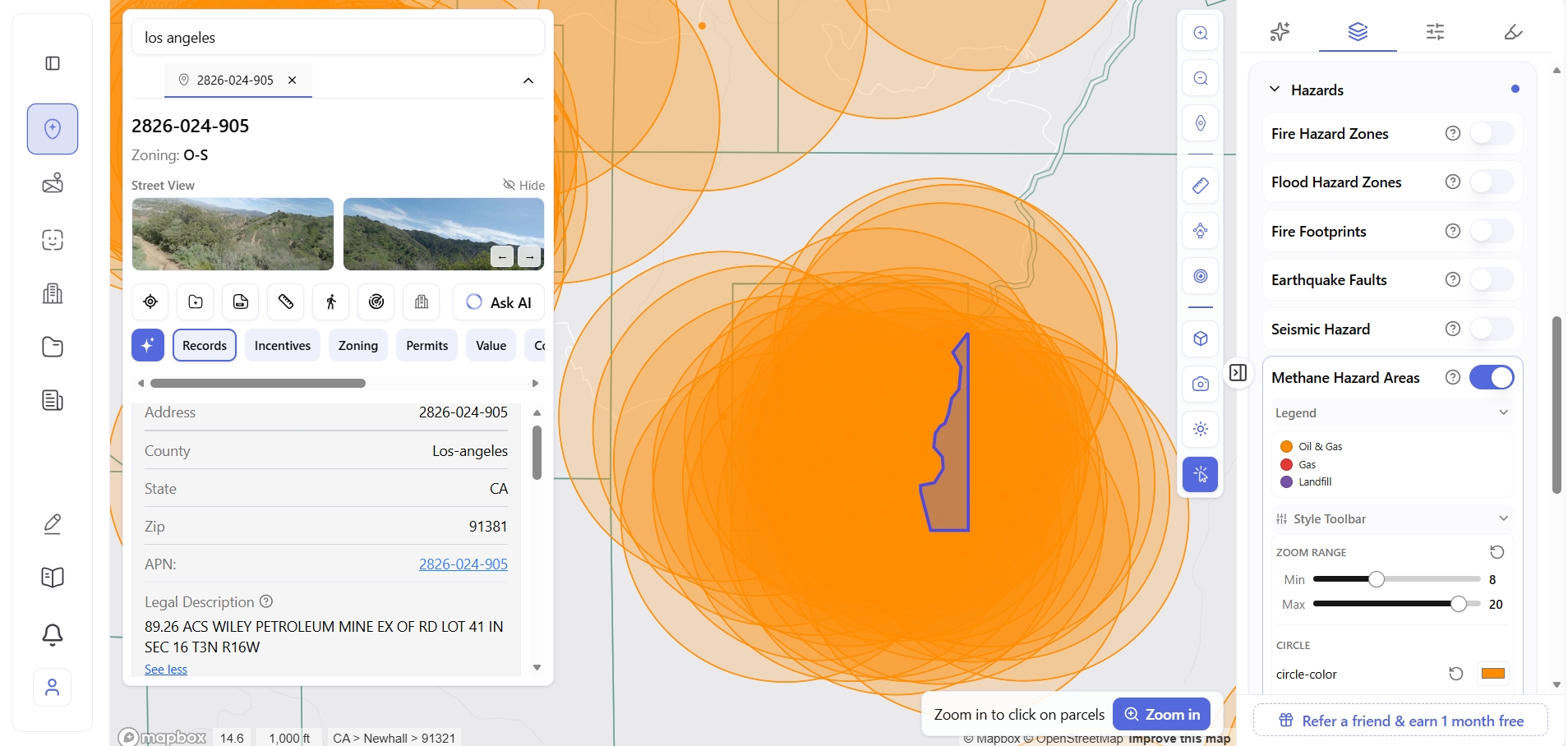 You’re no longer looking at a hazard source. You’re looking at a parcel – zoning, value, ownership, and every other hazard layer that applies to that address. That’s the workflow: a methane circle on the map becomes a complete pre-development research file in two clicks.
Sites Worth Paying Extra Attention To
Not every parcel needs a methane deep-dive. But these site types carry higher probability:
- Infill sites in historically active oil cities – LA Basin, Long Beach, Bakersfield, Houston, Denver. Historical drilling density means methane proximity is common even on sites with no visible surface indicators
- Sites near active or closed landfills – landfills close, get covered, get rezoned. The methane generation continues
- Urban sites near former industrial corridors – particularly where oil extraction was active in the early 20th century. Many wells have no surface markers
- Sites with unusually low asking prices – sometimes the number reflects something the seller already knows
The hazard layer doesn’t tell you whether to buy. It tells you what questions to ask – and gives you time to ask them before the clock is running.
The data exists. The layer is built. The only question is whether you check it before you make an offer – or after you’ve already signed.
Learn more
ArchiWise helps developers, investors, architects, and brokers go from address to decision in minutes, not weeks.
Whether you’re screening sites for multifamily development, evaluating zoning constraints, surfacing incentive eligibility like QCT and LIHTC, or assessing hazard risk before committing capital, ArchiWise runs every layer of analysis in one place.
Explore how ArchiWise helps teams screen development sites, analyze zoning, and make confident go/no-go decisions faster.