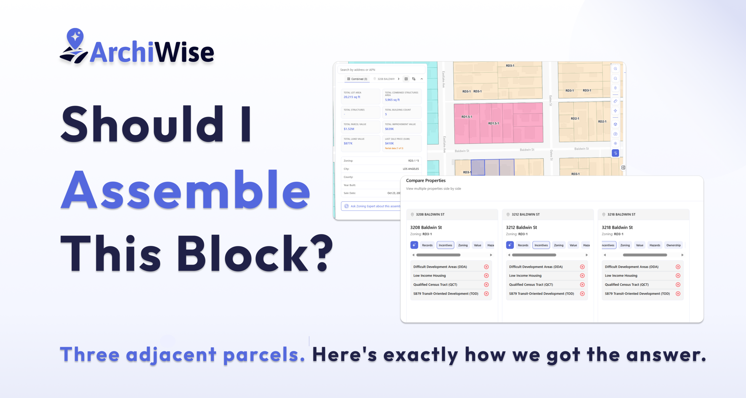
Three adjacent parcels. One development question. Here’s exactly how we got the answer.
There’s a block on Baldwin Street in Los Angeles. Three adjacent parcels, all owned separately, all built over a century ago. Each one carries two residential units on a modest footprint. Individually, none of them is particularly exciting.
Together, they tell a different story.
For a developer thinking about parcel assembly – combining multiple lots into a single, larger development site – the setup is familiar: aging structures, underutilized land, a neighborhood with real rental demand. But assembling parcels isn’t just about adding lot areas together. You need to know whether the zoning allows what you want to build, whether the lots can legally be merged, what the combined site can actually support, and whether the numbers work.
So we didn’t guess. We opened Archiwise, selected all three parcels – 3208, 3212, and 3218 Baldwin St – and ran a complete multi-parcel analysis covering records, zoning, value, incentives, and development constraints. From first click to clear answer.
Here’s exactly how it happened.
What Is Multi-Parcel Analysis?
Multi-parcel analysis means evaluating two or more land parcels together – to understand combined development potential, zoning compliance, risks, and market feasibility. It’s useful when you’re considering assembling adjacent lots or comparing multiple candidate sites.
Archiwise supports this with up to five parcels simultaneously. When parcels are selected, Archiwise aggregates the data across all of them at once: combined lot area, total assessed value, combined structures, zoning consistency, shared hazard exposure, and incentive eligibility for the assemblage as a whole.
Two use cases drive this feature:
Parcel assembly – evaluating adjacent lots together to understand what’s possible when you combine them. Instead of running three separate analyses and trying to mentally merge the results, Archiwise aggregates the data instantly: combined lot area, total value, unified zoning picture, and a single AI-powered question that covers merger requirements, permitted uses, and development constraints for the entire assemblage at once.
Candidate site comparison – evaluating multiple non-adjacent parcels side by side to find the strongest opportunity. Instead of researching each site separately and comparing notes across browser tabs, Archiwise puts all the data – zoning, incentives, value, hazards – in one view, for all candidate sites simultaneously. One session. One clear answer.
This analysis covers both. First: three adjacent parcels on the same block, evaluated as a potential assembly. Then: three non-adjacent candidate sites compared simultaneously.
Part 1: Parcel Assembly – Baldwin Street, Los Angeles
Step 1: Select the Parcels – What Are We Working With?
The first step in any multi-parcel analysis is selecting the parcels and understanding what you’re looking at individually before combining them.
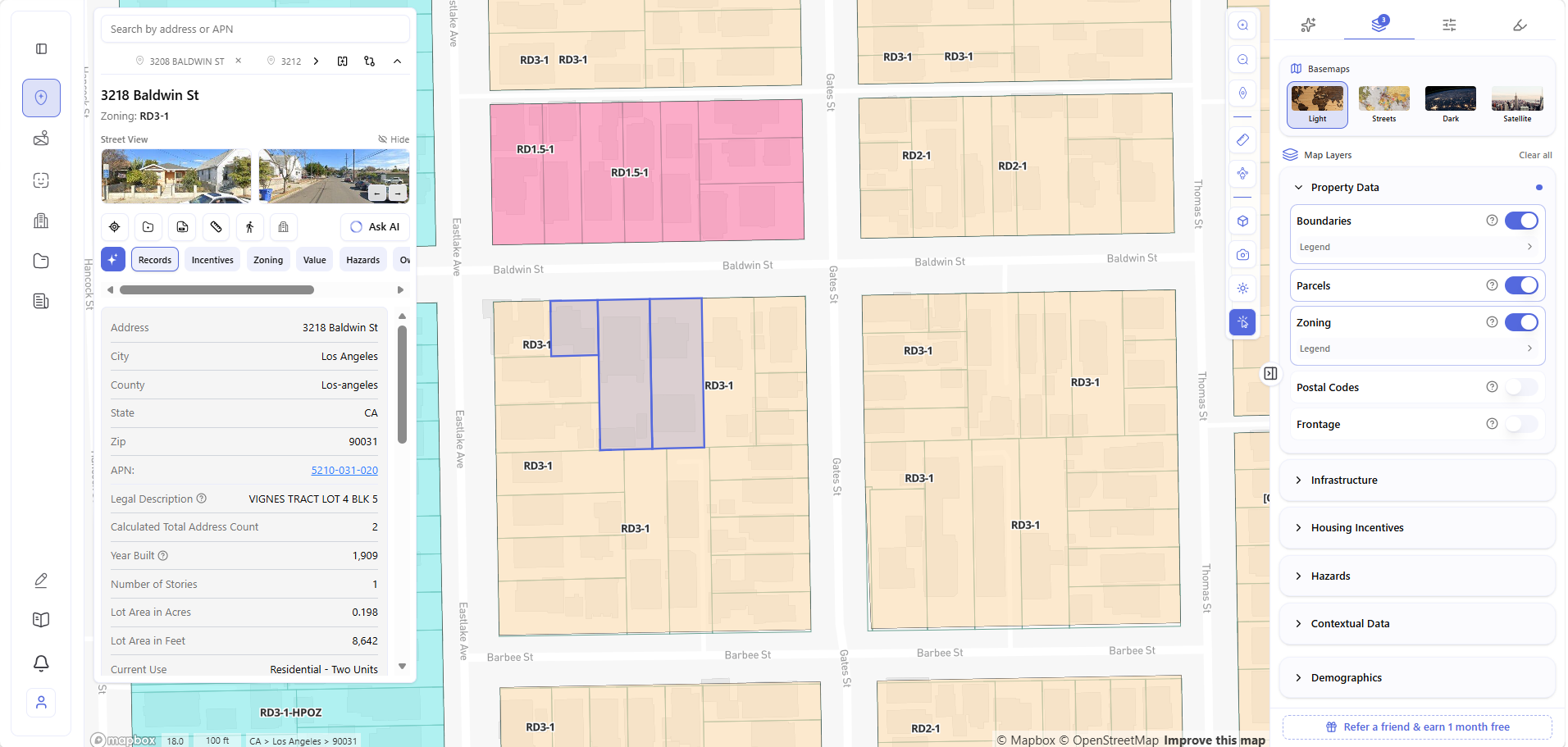
Three parcels. Three separate ownerships. All zoned RD3-1. All built between 1909 and 1922. All currently used as two-unit residential. Each lot is just under 0.2 acres – modest on its own, but the combined picture is what matters.
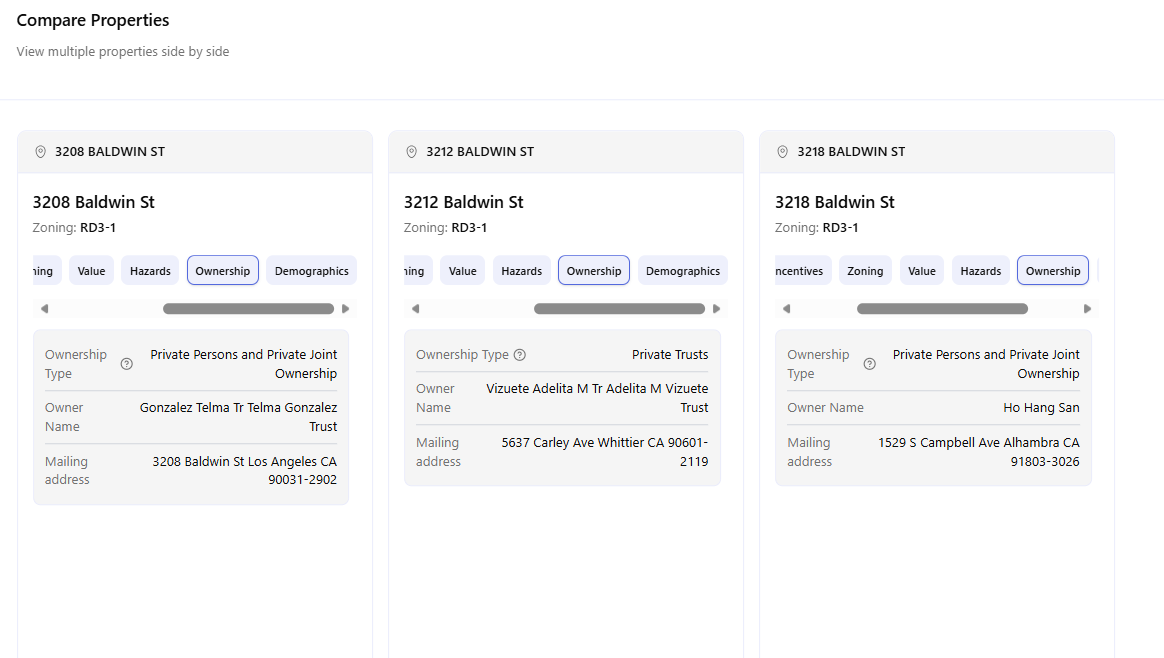
Step 2: Compare Properties – Are They Consistent?
With three parcels selected, Archiwise opens the Compare Properties view – all three side by side, every data field visible simultaneously. No switching tabs. No cross-referencing separate searches.
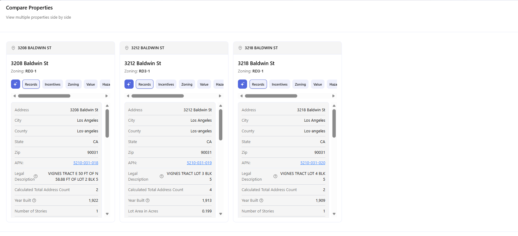
What the comparison immediately confirms:
- Zoning is consistent – all three parcels are RD3-1. No zone mismatch to navigate.
- Same jurisdiction – all three in Los Angeles, same zip code, same county. One planning department, one set of rules.
- Similar vintage – built 1909–1922. Historic preservation review is worth flagging early.
- APNs are sequential – 5210-031-018, 019, 020. Contiguous parcels from the same original tract map (VIGNES TRACT), which simplifies the merger process.
This is the kind of consistency that makes an assembly viable from the start.
Step 3: The Combined Picture – What Does the Assembly Actually Look Like?
With all three parcels selected, Archiwise shows the Combined summary – the aggregated data for the assemblage as a whole.
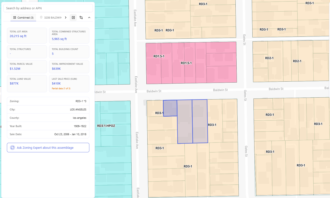
The combined data tells a clear story:
- Total lot area: 20,215 sq ft – roughly half an acre. A meaningfully larger canvas than any individual parcel.
- Total parcel value: $1.52M – land at $877K, improvements at $639K. The land value relative to total value signals the existing structures contribute relatively little. That’s an acquisition signal.
- Last sale price: $410K (partial – only one of three parcels has recorded sale data). The gap between that historical price and the current $877K land value tells you land has appreciated significantly.
- Building count: 5 structures – all aging, all low-density. The existing improvements are not the reason to buy this block.
- Year built: 1909–1922 – worth flagging for historic preservation review before any demolition plan is finalized.
And at the bottom of the panel: “Ask Zoning Expert about this assemblage.” That button is exactly where the real analysis begins.
Step 4: Ask the AI – What Can Actually Be Built Here?
When you click “Ask Zoning Expert about this assemblage”, Archiwise automatically loads all three parcels into the AI Zoning Expert and generates a comprehensive question covering everything a developer needs to know: whether multifamily is permitted by right, whether the lots can legally be merged, and what development constraints apply to the combined site.
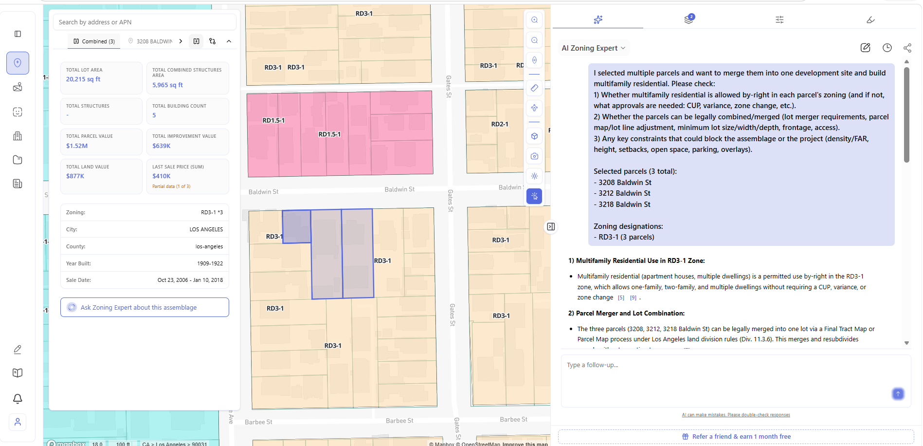
Here’s what the AI Zoning Expert confirmed – pulled directly from the LA Zoning Code:
Multifamily residential: permitted by right. The RD3-1 zone explicitly allows one-family, two-family, apartment houses, and multiple dwellings without requiring a CUP, variance, or rezoning.
Lot merger: legally possible. The three parcels can be merged via a Final Tract Map or Parcel Map process under LA land division rules (Division 11.3.6). A Lot Line Adjustment is also available under Division 13B.7.2 if the number of lots stays the same or decreases. Requirements: same ownership entity, recorded final map with LA County Recorder, minimum lot width of 60 ft, minimum lot area of 6,000 sq ft – all met by the combined 20,215 sq ft parcel.
Key development constraints for the combined site:
- Density: Minimum lot area per dwelling unit is 3,000 sq ft in RD3-1. Base calculation: 20,215 ÷ 3,000 = 6.7 → 7 base units
- Height: Maximum 45 ft
- Setbacks: Front 15 ft, sides 10% of lot width (min 5 ft, max 10 ft), rear 15 ft
- Parking: 1–2 spaces per unit depending on unit size, plus guest parking for first 30 units
- Open space: Required for 6+ units under LAMC Section 12.21 G
Density bonus potential: Under California State Density Bonus Law (Gov Code Section 65915), including affordable units unlocks a 35% density increase: 7 base units × 1.35 = up to 10 units with density bonus.
The Assembly Decision: Go
After running every layer of analysis, the verdict on this assemblage is clear: the zoning works, the lot area is sufficient, the merger path is documented, and multifamily is permitted by right. This is a go.
What the analysis showed in favor:
- Zoning is consistent and permissive – RD3-1 on all three parcels, multifamily permitted by right
- Combined lot area: 20,215 sq ft – comfortably above the 6,000 sq ft minimum
- Base density: 7 units, rising to 10 with state density bonus
- Parcels are contiguous from the same original tract – lot merger is straightforward
- Land value ($877K) significantly exceeds historical sale prices – redevelopment upside exists
What to address before committing:
Ownership consolidation – Archiwise’s Ownership tab shows all three parcels are held by different entities: 3208 by Gonzalez Telma Trust, 3212 by Vizuete Adelita M Trust, and 3218 by Ho Hang San. All three must be under the same ownership before a lot merger can be recorded. Knowing this before making offers changes your sequencing and negotiation strategy entirely.
Incentives screening – the Incentives tab shows all three parcels return the same result: DDA ❌, Low Income Housing ❌, QCT ❌, SB79 ❌. No incentive programs currently apply to this assembly. This doesn’t kill the deal – but it does mean the financing stack relies on market-rate development or state density bonus alone, without the LIHTC boost available at other nearby sites.
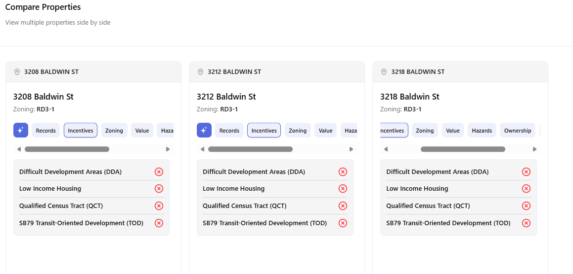
The ownership data and incentives picture are clear. This assemblage is a go.
Part 2: Candidate Site Comparison – Three Non-Adjacent Parcels
Parcel assembly isn’t the only reason to run a multi-parcel analysis. Sometimes you’re not trying to combine sites – you’re trying to choose between them.
![Archiwise map view showing 2219 Gates St and two other parcels selected across different streets — Records tab showing 3418 N Broadway details: zoning [Q]C4-1XL-CDO, Year Built 1901, Lot Area 0.191 acres; map showing multiple zone colors — [Q]C4-1XL-CDO in blue/teal, RD3-1, RD2-1, RD1.5-1, PF-1 all visible across the area; Zoning layer active in right panel](https://blog.archiwise.ai/wp-content/uploads/2026/05/7.png)
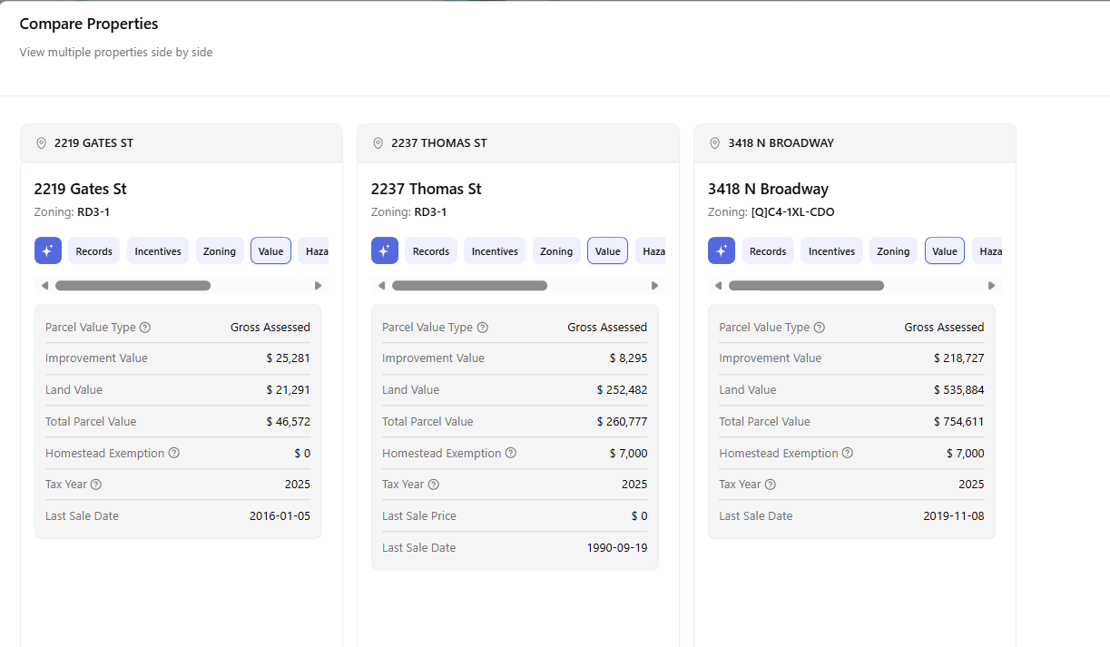
Archiwise lets you select parcels from completely different streets, different neighborhoods, or different parts of the city and compare them side by side in one view. For this example, three non-adjacent parcels in Los Angeles ZIP 90031 were selected – 2219 Gates St, 2237 Thomas St, and 3418 N Broadway – as competing candidates for the same development opportunity.
![: Archiwise Combined (3) panel open showing Total Lot Area 23,287 sq ft, Total Parcel Value $1.06M, Total Land Value $810K, Zoning RD3-1 x2 [Q]C4-1XL-CDO with warning flag, Year Built 1901-1913, Sale Date Sep 1990 - Nov 2019; Compare properties tooltip visible on grid icon button at top of panel; map showing selected parcels highlighted; Ask Zoning Expert about this assemblage button at bottom](https://blog.archiwise.ai/wp-content/uploads/2026/05/9.png)
Once all three parcels are selected, click the Compare Properties button in the info modal – visible at the top of the panel – and Archiwise opens the full side-by-side view instantly.
![Archiwise Compare Properties view showing 2219 Gates St (RD3-1, built 1913), 2237 Thomas St (RD3-1, built 1905, 0.229 acres), and 3418 N Broadway ([Q]C4-1XL-CDO, built 1901) side by side — zoning difference immediately visible with third parcel carrying a commercial overlay designation vs residential zoning on the other two; APNs 5210-030-013, 5211-001-012, 5208-030-017 visible](https://blog.archiwise.ai/wp-content/uploads/2026/05/10.png)
The zoning mismatch is visible immediately. Two parcels are RD3-1 – straightforward multifamily residential zoning. The third, 3418 N Broadway, carries a [Q]C4-1XL-CDO designation – a commercial zone with a Qualified condition and Community Design Overlay. Archiwise flags this with a ⚠️ warning on the combined Zoning field, signaling that these parcels are not equivalent candidates.
Comparing Incentives, Value, and More
Rather than using the automatic assemblage question, here the question is asked directly to compare development potential across all three sites. But first – the comparison doesn’t stop at zoning. Archiwise lets you switch tabs across all three parcels simultaneously.
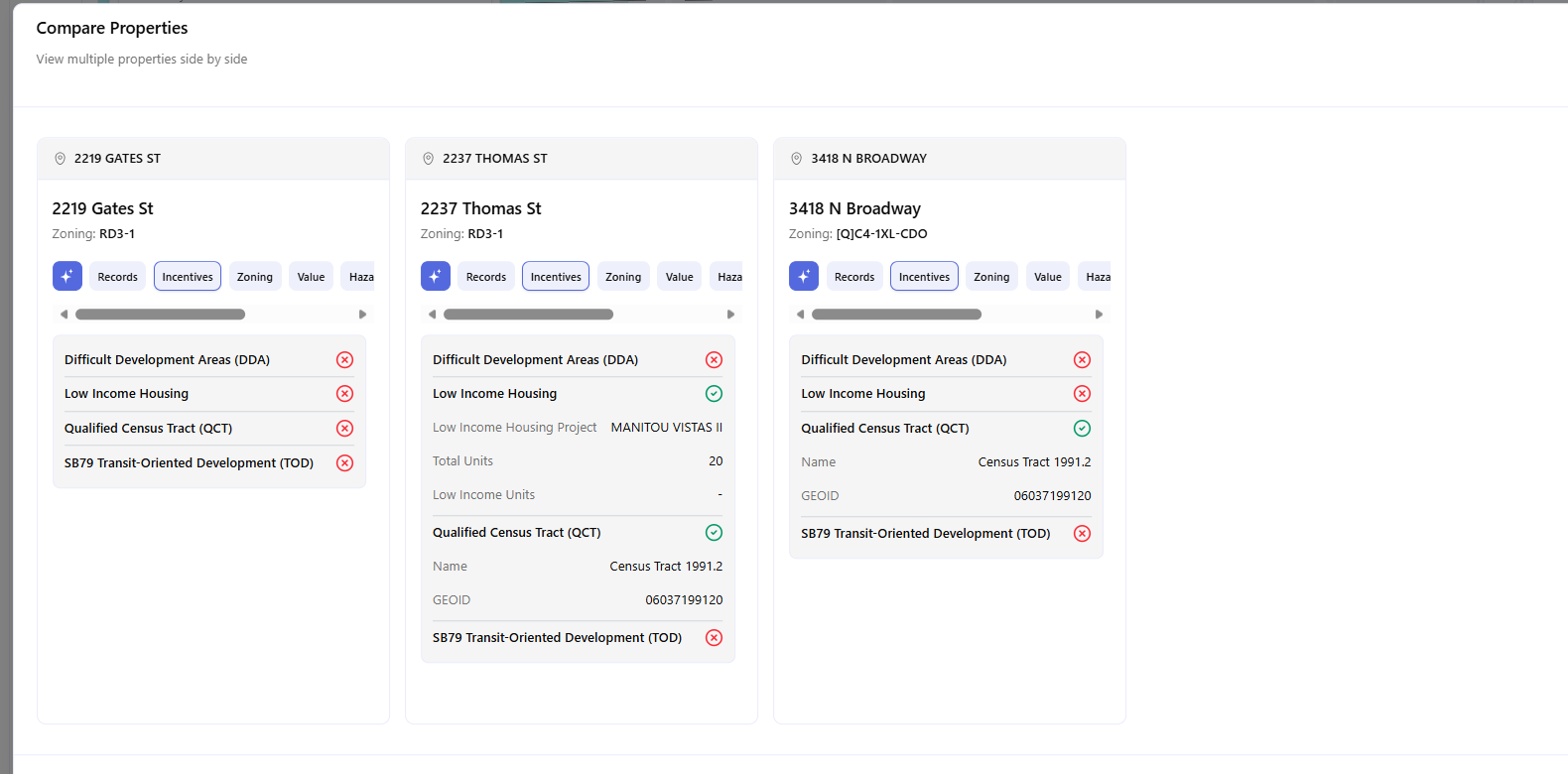
Incentives tab:
- 2219 Gates St – no incentive programs apply. No QCT, no LIHTC precedent nearby.
- 2237 Thomas St – QCT eligible (Census Tract 1991.2) and MANITOU VISTAS II nearby (20 units) confirms the LIHTC financing pathway works in this immediate neighborhood.
- 3418 N Broadway – QCT eligible but no LIHTC precedent nearby. Financing pathway unproven at this location.
Value tab:
2219 Gates St – assessed value of $46,572 is unusually low. May not reflect market reality. No homestead exemption – investment-owned.
2237 Thomas St – land value $252,482 against improvement value of only $8,295. The existing structure contributes almost nothing – a clear redevelopment signal. Held since 1990.
3418 N Broadway – most expensive at $754,611. Homestead exemption confirms owner-occupied – harder negotiation, potentially higher acquisition premium.
This tab-by-tab comparison – Records, Zoning, Incentives, Value, Hazards – is available across all selected parcels simultaneously. You’re not switching between separate searches.
The AI Verdict – Which Site Is Strongest?
With the full picture in view, the question is asked directly:
“I am evaluating these three parcels as candidate development sites for multifamily residential. Which one has the strongest development potential? Please compare them based on zoning, permitted uses, lot size, any development constraints, and flag any issues I should be aware of before making an offer.”
The AI Zoning Expert’s verdict, pulled directly from the LA Zoning Code:
2237 Thomas St is the strongest candidate. RD3-1 zoning, 9,972 sq ft lot, multifamily permitted by right, no overlays complicating residential development. Base density: 9,972 ÷ 3,000 = approximately 3 base units. With 35% state density bonus: up to 4 units with affordable housing inclusion. Larger lot, cleaner zoning, confirmed LIHTC pathway – the strongest case of the three.
2219 Gates St is viable but constrained. Same RD3-1 zoning, but the lot at 4,982 sq ft is below the 6,000 sq ft minimum lot area for RD3-1. The existing use may be legal non-conforming, but new development to full RD3-1 standards requires verification with city planning before any assumptions are made.
3418 N Broadway carries the most risk. The [Q]C4-1XL-CDO designation – a Qualified condition and Community Design Overlay on top of commercial zoning – means residential uses may require a conditional use permit. Design review requirements may limit height and FAR. This parcel requires direct verification with city planning before any residential development assumptions are made.
The answer in one sentence: 2237 Thomas St offers the strongest development potential. 2219 Gates St is a smaller but clean alternative. 3418 N Broadway needs more due diligence before it can be evaluated on equal footing.
What Multi-Parcel Analysis Changes
The traditional approach to evaluating multiple sites looks like this: pull each parcel separately from the county assessor, open separate tabs for each zoning code, manually calculate density for each lot, and try to hold all the variables in your head or a spreadsheet at the same time. For three sites, that takes hours. For five, most of a working day.
Archiwise compresses all of it into one session:
- Select up to five parcels – adjacent or anywhere in the US
- See combined lot area, value, and building data aggregated instantly
- Compare all parcels side by side across every tab – Records, Zoning, Incentives, Value, Hazards
- When you click “Ask Zoning Expert about this assemblage”, Archiwise automatically loads all selected parcels into the AI Zoning Expert and generates a comprehensive question covering merger requirements, permitted uses, and development constraints – ready to send with one click
- You can also type your own question instead – for example, asking which site has the strongest development potential for a specific use. Either way, the AI answers with the applicable zoning code cited as the source
Whether you’re assembling a block or choosing between candidates, the question is always the same: which site is worth moving on? Archiwise answers it before anyone else has even started looking.
Evaluate any combination of sites – before you commit.
Archiwise supports multi-parcel analysis for up to five parcels simultaneously – combined value data, zoning comparisons, and AI-powered assemblage and candidate analysis in one view.
Learn more
ArchiWise helps developers, investors, architects, and brokers go from address to decision in minutes, not weeks.
Whether you’re screening sites for multifamily development, evaluating zoning constraints, surfacing incentive eligibility like QCT and LIHTC, or assessing hazard risk before committing capital, ArchiWise runs every layer of analysis in one place.
Explore how ArchiWise helps teams screen development sites, analyze zoning, and make confident go/no-go decisions faster.