By ArchiWise AI | For Developers, Investors & Architects
Imagine two developers eyeing the same parcel. One spends two weeks waiting for a consultant’s zoning report. The other gets the same information in under an hour – and submits their offer first.
That’s not a hypothetical situation. That’s what’s happening right now in real estate.
A new wave of AI tools for real estate developers has begun to change how developers, investors, and architects find and evaluate land. According to a 2025 report by Bisnow, these tools are rapidly accelerating the pace of acquisition – helping buyers find better sites, move faster, and avoid costly mistakes. The firms using them aren’t just working more efficiently. They’re building a real competitive advantage.
This post breaks down exactly where that advantage comes from – and how ArchiWise delivers it, stage by stage.
The Land Pipeline Problem AI Was Built to Solve
Before we talk about AI, let’s talk about the problem it’s solving.
Building a solid pipeline of viable development sites has always been hard. But in 2025, it’s become one of the most constrained parts of the entire development business. Soaring land prices, tight zoning restrictions, and shrinking inventory in core markets have made well-located parcels genuinely scarce. As one industry analysis put it, land acquisition has become “one of the most complex – and costly – steps in the real estate development process.”
At the same time, the process itself has gotten slower. Epcon Franchising’s national land team noted that zoning, entitlements, and permitting take significantly longer than they used to – and deals that once closed quickly now demand extended commitment and patience.
The traditional response to all this? Hire more analysts. Put more hours in. But that approach has limits. It doesn’t scale, and it doesn’t make the underlying data any easier to access.
This is exactly what AI was built to fix. Instead of a team manually screening three to five sites per week, AI site screening software allows developers and investors to evaluate dozens of sites simultaneously – with more depth and accuracy than manual research allows. That means a better pipeline, built faster, without burning through resources on sites that don’t pencil.
Everything that follows shows how this plays out in practice.
Three Specific Places AI Changes the Game
AI doesn’t improve land acquisition in a vague, general way. It changes specific steps – the ones where most time is lost and most mistakes are made.
1. Zoning Analysis: From Days to Hours
Zoning is the foundation of every acquisition decision. What can you build? How tall? How dense? What requires special approval?
Traditionally, answering those questions meant reading through hundreds of pages of municipal code – or paying a consultant to do it. The United States has more than 30,000 local zoning jurisdictions, each with its own rules, terminology, and exceptions. A single city’s zoning code can run 500 to 1,000 pages.
AI changes this dramatically. According to The AI Consulting Network, AI zoning tools – including today’s best AI zoning analysis tool options – can reduce the time to evaluate a property’s development potential from three to five business days to under four hours – by automatically interpreting municipal code across thousands of jurisdictions.
For a team evaluating 20 sites, that’s the difference between a month of research and a single afternoon.
2. Entitlement Risk: Catching Hidden Constraints Early
Zoning classification is just the starting point. Many parcels sit within overlay districts – flood zones, historic preservation areas, transit-oriented development corridors – that add requirements on top of base zoning. Overlay district analysis and land use analysis software are essential to catching these hidden constraints before they become costly surprises.
AI tools automatically layer these overlays onto the base zoning analysis. As The AI Consulting Network explains, when a property falls within an overlay district, the AI identifies the additional restrictions and adjusts the development potential analysis accordingly.
This matters most before you’re committed. Catching an entitlement obstacle before signing a purchase agreement is cheap. Catching it after you’ve closed – and paid for design, permits, and carrying costs – can be devastating.
3. Faster Underwriting, Real Competitive Edge
Speed in underwriting isn’t just about efficiency. When two buyers are competing for the same site, the one who can evaluate it faster and more accurately wins.
CBRE’s 2025 Tech Adoption Report found that development teams using AI for underwriting completed preliminary analysis three times faster than those without – a gap large enough to affect who gets the deal. And according to Goldman Sachs estimates from mid-2025, AI tools could reduce due diligence costs by 20 to 35% for large portfolios.
For investors managing multiple acquisitions at once, that math adds up quickly.
How ArchiWise Works: A Pre-Acquisition Walkthrough
ArchiWise was built specifically for the pre-acquisition stage – the decisions made before design begins, before permits are filed, and before capital is committed. It brings together five distinct modules into one decision workflow, each designed to answer the exact question a developer, investor, or architect needs at that specific moment. Here’s what that looks like in practice.
Stage 1: Initial Site Screening
The question at this stage is simple: is this site even worth pursuing? Before spending money on consultants or time on detailed research, you need a fast, reliable signal.
ArchiWise’s AI Site Selection module goes beyond listed inventory. Because listed properties represent less than 5% of viable development opportunities, the platform analyzes all parcels in a market – listed or not – based on development criteria. You can describe your ideal project in plain English (“find multifamily-zoned parcels within 10 miles of downtown Los Angeles”) and get a filtered, scored map of results instantly. Each parcel is ranked based on development potential, mispriced density, and by-right paths that others may have missed.
The platform also uses satellite imagery to visually segment parcels – identifying lot configuration, existing use, and physical characteristics that signal motivated sellers or underutilized land. Show-stopping issues like flood zones, environmental overlays, and utility gaps are flagged automatically, before any consultant is engaged.
Output: A ranked shortlist of viable sites with opportunity scores, including off-market parcels – and a credible go/no-go signal in the time it used to take just to pull a zoning map.
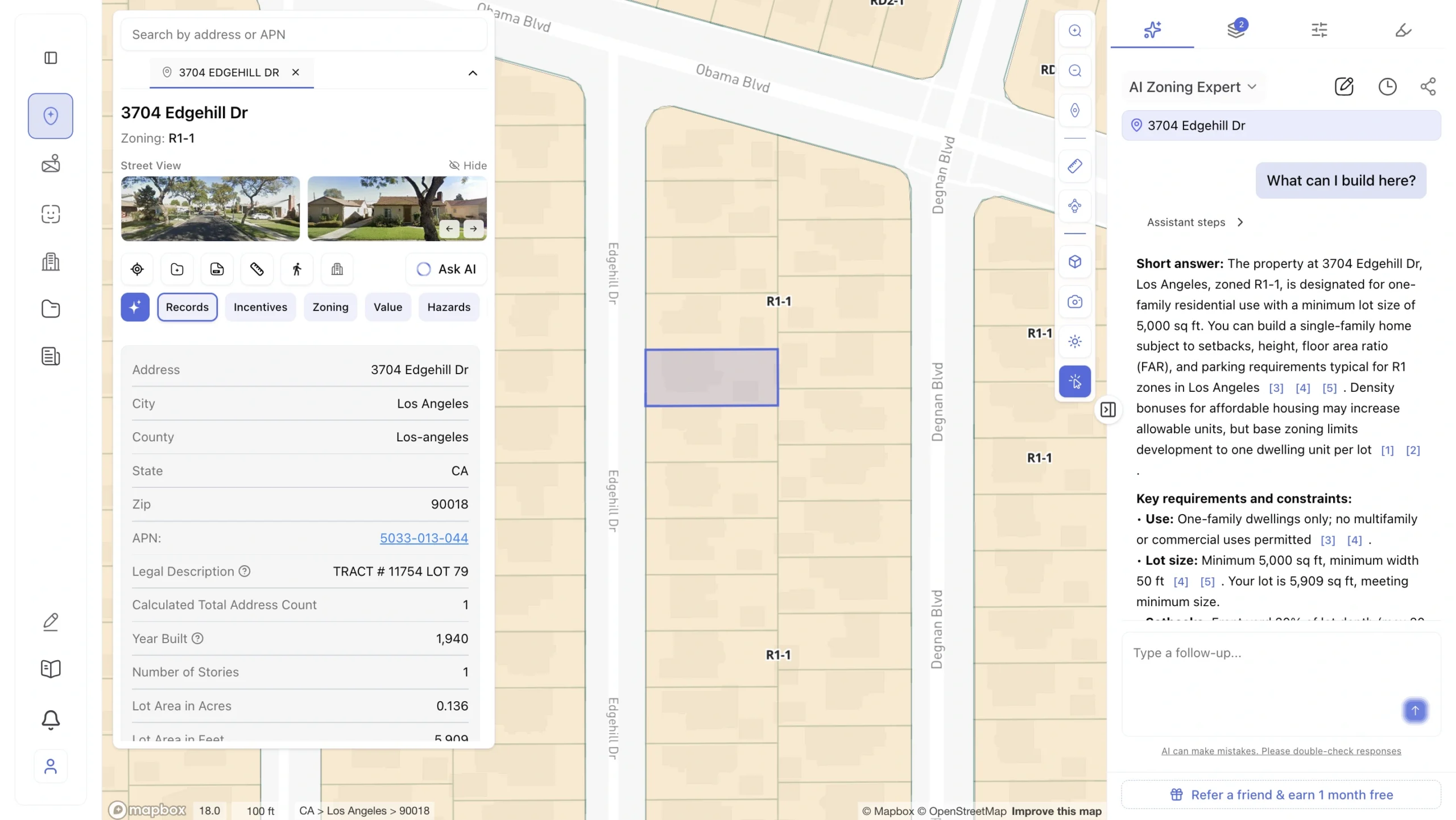
Stage 2: Zoning Analysis
Once a site clears the initial screen, the next question is: what can you actually build there? This is where most manual research gets stuck – buried in municipal codes, overlay maps, and conflicting regulations across thousands of jurisdictions.
ArchiWise’s AI Zoning Expert delivers a parcel-specific breakdown instantly: setbacks, height limits, FAR, lot coverage, permitted vs. conditional uses, parking requirements, and any overlay zones or special districts that apply to that exact address. Not a generic zone description – the actual rules for your specific parcel, with citations. Data is pulled from official municipal sources and updated within 24–48 hours of any code amendments. Accuracy is verified at 99.2% against professional consultant reports.
Critically, the module also identifies housing incentive programs and density bonus eligibility – state and local pathways that can unlock significantly more units than base zoning suggests. A site listed at 20 units may legally support 26 by-right, once the right program is identified. This is where hidden value gets found before you commit.
Output: A complete, citation-backed zoning picture for your specific parcel – including density bonus calculations and automated flags for any overlays or constraints. What used to take 3–7 days and $1,500–$6,000 in staff time now takes minutes.
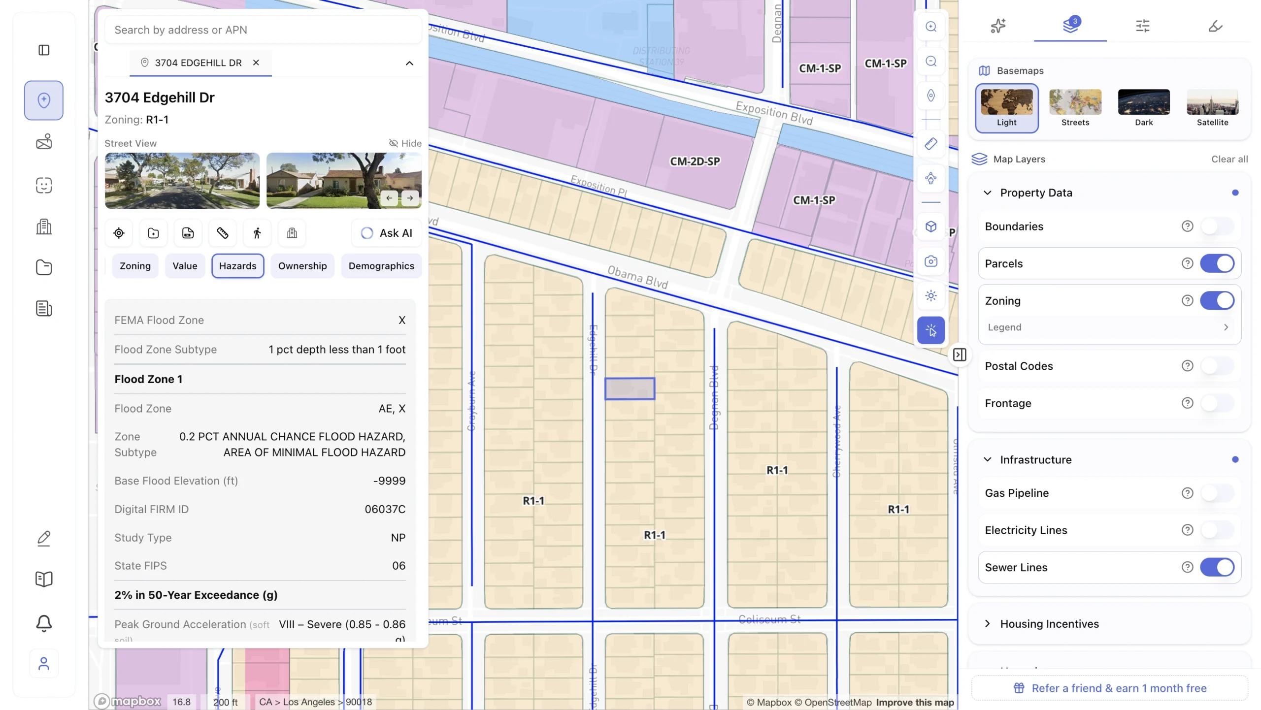
Stage 3: Area Analysis
Zoning tells you what you can build. Area analysis tells you whether you should. The question here is: do the conditions around this site actually support a successful project long-term?
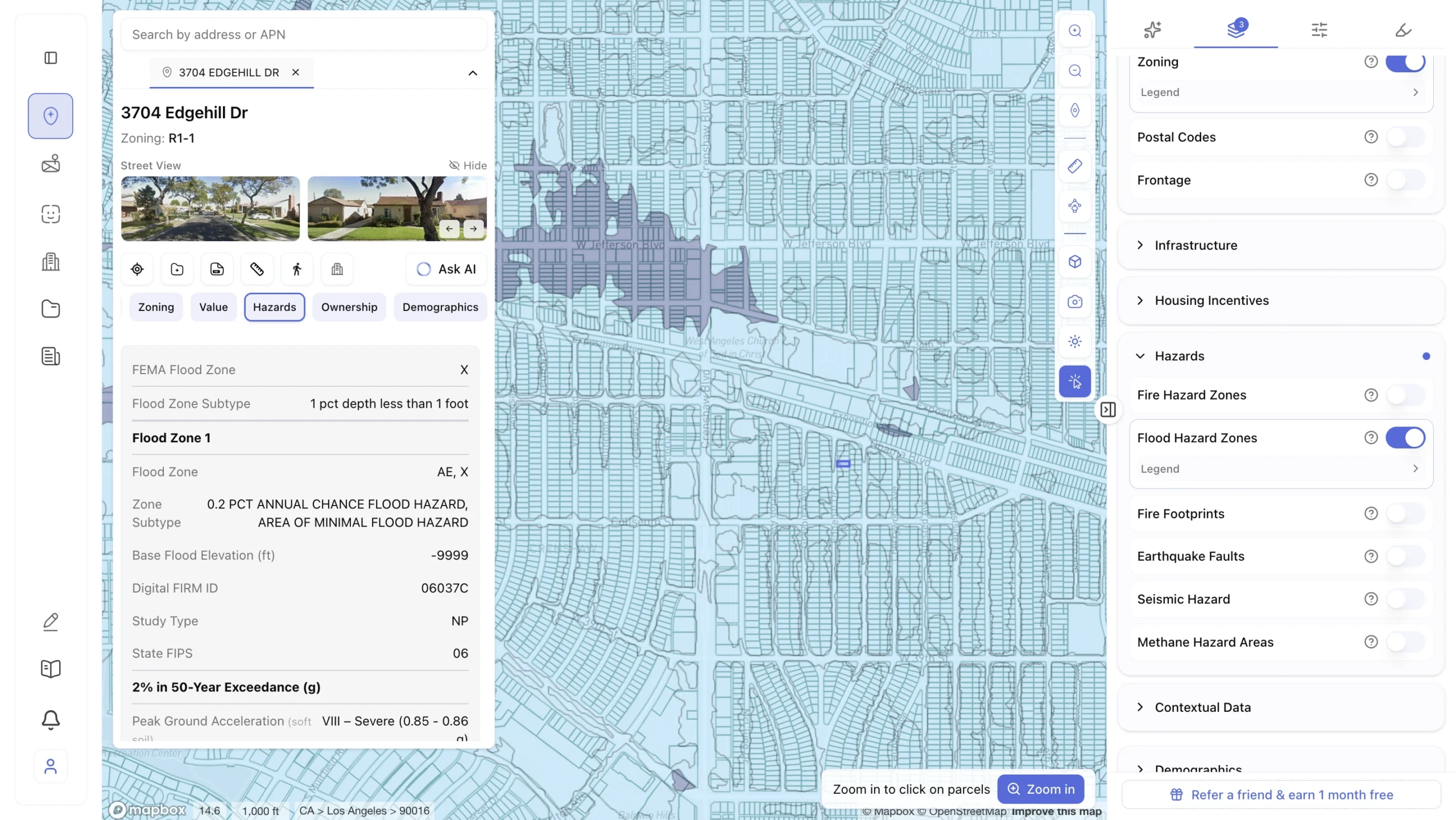
ArchiWise’s Area Intelligence module pulls from 50+ authoritative sources – USGS, FEMA, EPA, the Census Bureau, CoStar, local planning departments – and organizes the analysis into four layers:
Hazards: flood zones, seismic risk, soil contamination, slope analysis, and environmental protection overlays. Environmental surprises are the leading cause of deal delays. This layer catches them at Day 1, not Day 45.
Infrastructure: water, sewer, and utility capacity; planned road and transit projects; required off-site improvements. Infrastructure gaps discovered late can add major cost or kill a project entirely.
Demographics: population growth, income levels, employment trends, school quality, walkability, and crime trends. This tells you whether the right demand exists for the product you’re planning to build.
Market comps: development pipeline, absorption rates, rental vacancy, rent growth, and competing projects within radius. Market timing determines whether your project leads or saturates an overbuilt submarket.
Output: A structured location analysis covering physical risk, infrastructure readiness, demand quality, and market conditions – all linked to your specific parcel, with data refreshed continuously and “last updated” dates shown per layer.
Stage 4: Feasibility Study
The question here is: does this project make financial sense – and which development strategy produces the best return? Traditional feasibility studies answer the first part and miss the second. They test one scenario and stop. ArchiWise tests all of them.
The Feasibility Analysis module starts by generating the maximum buildable envelope from all applicable zoning constraints – before any architect is engaged. It then runs multiple development scenarios simultaneously: studio-heavy vs. family units, residential-only vs. mixed-use, market-rate vs. affordable density bonus, surface vs. structured parking, single phase vs. phased development. Each scenario gets a complete pro forma: development budget, revenue projections, ROI, IRR, cash-on-cash return, and downside sensitivity testing.
Every scenario is ranked by IRR, risk-adjusted return, time to stabilization, capital requirement, and approval risk. Construction cost estimates are based on location-specific RSMeans data, accurate to ±10–15% for preliminary analysis – reliable enough for a go/no-go decision before any design money is spent.
Output: A ranked comparison of multiple development strategies, each with a full financial model. The traditional alternative – a consultant feasibility study – costs $10,000–$25,000 and takes 3–4 weeks. ArchiWise delivers it in minutes.
Stage 5: Entitlement Risk Analysis
The final question before committing capital: will the city actually approve this? Code compliance tells you what’s allowed. Entitlement risk analysis tells you what gets approved – and how long it realistically takes.
ArchiWise’s Entitlement Viability module is built on a database of actual project outcomes, tracked by jurisdiction, planning district, and project type. It goes beyond zoning code to show what planning commissions actually do. Four data layers drive the analysis:
Approval patterns: historical approval rates by project type and location. One district may approve 89% of similar projects; an adjacent district approves 41%. That difference belongs in your acquisition model.
Timeline forecasting: predicted approval timelines based on real outcomes for comparable projects, not city estimates. Forecast accuracy has improved from ±25% in 2023 to ±8% in 2025 as more project outcomes are tracked.
Planning commission intelligence: individual commissioner voting patterns, recurring concerns, and swing vote tendencies. Knowing that a key commissioner consistently votes against projects over three stories is actionable – before you finalize your design.
Neighborhood opposition and approval conditions: which areas generate resistance, what objections come up most often, what concessions tend to resolve them, and the standard conditions cities attach to approvals – so you can budget for them before they become surprises.
Output: An approval probability score, a realistic timeline estimate, a breakdown of political risk by district and commissioner, and a recommended strategy – whether to push for maximum density or take the faster by-right path and start construction months earlier.
Together, these five modules form a complete pre-acquisition decision workflow. Each stage builds on the last. By the time you’re ready to make an offer, you know the site’s potential, its risks, its optimal development strategy, and its realistic approval path – before a dollar of design cost has been spent.
The Adoption Gap: Why Right Now Is the Right Time
Here’s the honest picture of where the industry stands.
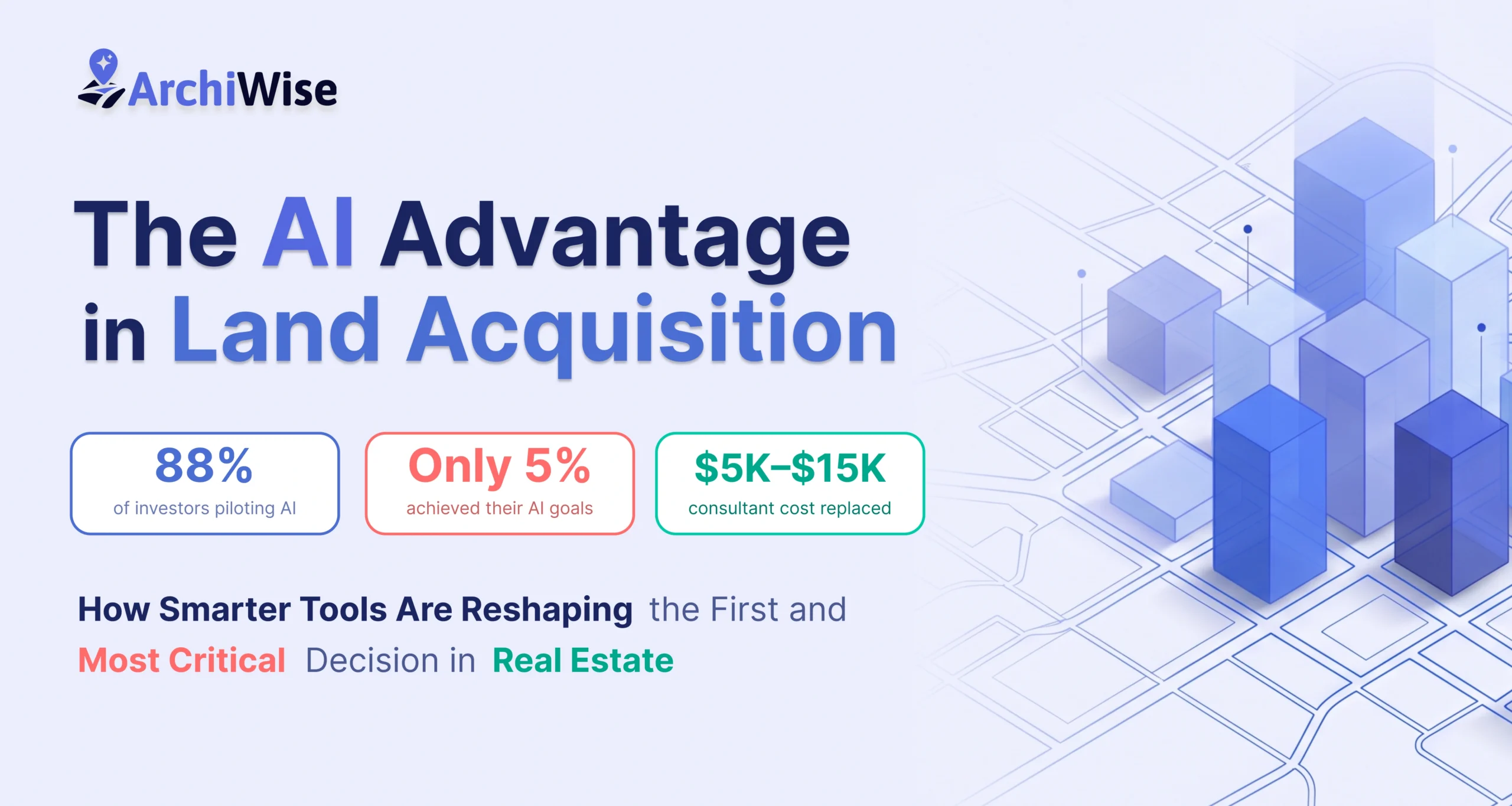
According to JLL’s 2025 Global Real Estate Technology Survey – which surveyed over 1,500 senior decision-makers across 16 markets – 88% of real estate investors have started piloting AI. That sounds like widespread adoption. But dig deeper, and only 5% have fully achieved their AI program goals. More than 60% remain unprepared strategically, organizationally, and technically.
Most firms are experimenting with AI in back-office functions: lease abstraction, property management, energy reporting. Very few have embedded it into the acquisition workflow – which is where the highest-stakes, most irreversible decisions are made. And even fewer are leveraging a proptech SaaS platform or zoning intelligence platform purpose-built for pre-development decisions.
That gap is the opportunity.
JLL’s research makes the stakes clear: the window to gain a competitive advantage through AI is not staying open indefinitely. The cost of inaction isn’t just slower growth – it’s the risk of falling behind as the industry rewards those who move first.
One industry leader put it plainly: “If you’re depending on having boots on the ground to find deals, you will be left behind, because sophisticated funds will be algorithmically driven.”
The Bottom Line
Land acquisition hasn’t fundamentally changed in decades. You still need the same things: the right site, the right zoning, a clear understanding of what you can build, and the confidence to act before someone else does.
What’s changed is how fast you can get that information – and how much of it you can process at once.
AI won’t replace the judgment that comes from years in this business. But it will make that judgment faster, better-informed, and more defensible.
The firms building that capability now – into their acquisition workflow, not just their back office – are the ones who will see the pipeline others miss and close the deals others lose.
Your next site is already on someone else’s screen. While you’re waiting on a consultant’s report, a developer using ArchiWise already has the zoning, the feasibility, and the go/no-go – in the time it took you to read this sentence. That’s the power of AI zoning research automation. Don’t bring a spreadsheet to an AI fight.
Learn more
ArchiWise helps developers, investors, architects, and brokers go from address to decision in minutes, not weeks.
Whether you’re screening sites for multifamily development, evaluating zoning constraints, surfacing incentive eligibility like QCT and LIHTC, or assessing hazard risk before committing capital, ArchiWise runs every layer of analysis in one place.
Explore how ArchiWise helps teams screen development sites, analyze zoning, and make confident go/no-go decisions faster.