Everything you need to decode LA zoning – and stop leaving money on the table.
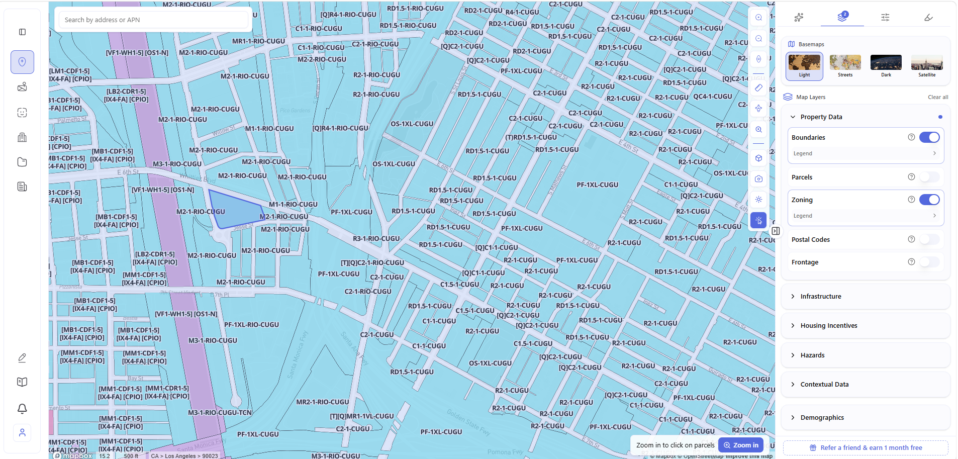
Every parcel on this map operates under a different rulebook.
And this is just one neighborhood, at one zoom level, in one of LA’s 34 community plan areas.
The One Thing That Separates Good Deals from Expensive Mistakes
In Los Angeles, two parcels on the same street can have completely different development potential. Same neighborhood. Same block. Wildly different rules.
That’s because LA zoning isn’t a single set of rules – it’s a stack of them. A base zone tells you the general category. A height district number tells you how tall and how dense. An overlay zone adds design or environmental rules. A [Q] condition imposes site-specific restrictions that aren’t visible in standard databases. A Specific Plan may override everything else entirely.
Miss any one of these and you’re designing a project that can’t be built, assuming entitlements that don’t exist, or leaving density bonuses worth hundreds of thousands of dollars on the table.
How to Read Any LA Zoning Code
A zoning designation like [Q]C2-1VL-CDO isn’t random. Each piece means something:
| Component | What It Tells You | Example |
| Base Zone | Primary land use category | R3, C2, M1 |
| Height District | Maximum height and FAR | 1, 1VL, 1XL, 2 |
| [Q] Condition | Site-specific ordinance restrictions | [Q] |
| Overlay Zone | Additional design or use rules | CDO, HPOZ |
| Specific Plan | Area rules that may override everything | CASP, Hollywood SP |
Decoded: [Q]C2-1VL-CDO = General Commercial (C2) + Very Limited height (30 ft max, FAR 1.5:1) + Community Design Overlay + Qualified condition.
Every component stacks. The most restrictive governs. You cannot evaluate a parcel from the base zone alone.
Residential Zones – What Actually Matters for Developers
The RD Zones: Your Most Common Multifamily Tool
The number in the RD zone name = minimum lot area per dwelling unit. That’s the whole formula. (LAMC Section 12.09.1)
| Zone | Min Area/Unit | Min Lot Area | Max Height | Front/Rear Setback | Side Setback |
| RD1.5 | 1,500 sq ft | 5,000 sq ft | 45 ft | 15 ft / 15 ft | 5 ft min |
| RD2 | 2,000 sq ft | 5,000 sq ft | 45 ft | 15 ft / 15 ft | 5 ft min |
| RD3 | 3,000 sq ft | 6,000 sq ft | 45 ft | 15 ft / 15 ft | 5–10 ft |
| RD4 | 4,000 sq ft | 8,000 sq ft | 45 ft | 15 ft / 15 ft | 5–10 ft |
| RD5 | 5,000 sq ft | 10,000 sq ft | 45 ft | 20 ft / 25 ft | 10 ft |
| RD6 | 6,000 sq ft | 12,000 sq ft | 45 ft | 20 ft / 25 ft | 10 ft |
Quick density math: 20,000 sq ft lot zoned RD3 = 20,000 ÷ 3,000 = 7 base units. With 35% state density bonus = up to 10 units.
RD zones are the fabric of LA multifamily – Koreatown, Silver Lake, Mid-City, Echo Park. If you’re buying multifamily-zoned land in those neighborhoods, you’re almost certainly in an RD zone.
Higher Density Zones
| Zone | Min Area/Unit | Max Height | Min Lot Area | Where You Find It |
| R3 | 800 sq ft | 45 ft | 5,000 sq ft | Common along commercial corridors citywide |
| R4 | 400 sq ft | Unlimited* | – | Koreatown, Hollywood, North Hollywood |
| R5 | 200 sq ft | Unlimited* | – | Downtown, Wilshire ‘Condo Canyon’ |
*Actual height set by the Height District number – not the zone itself.
Commercial Zones – The C2 Trap and the 1VL Problem
C2 is the most common commercial zone in LA. It permits retail, restaurants, offices, service stations, and more. What it does not permit by right: residential. That’s the C2 trap – developers assume they can add housing to a C2 site and discover they can’t without a rezoning or state law provision. (LAMC Section 12.14)
| Height District | FAR | Max Height | The Reality |
| 1 | 1.5:1 | 45 ft | Standard commercial corridors |
| 1L | 1.5:1 | 75 ft | Better than it looks |
| 1VL | 1.5:1 | 30 ft | ⚠️ The trap – C4-1VL sounds dense, isn’t |
| 1XL | 1.5:1 | 22 ft | Near-residential transition |
| 2 | 6:1 | Varies | Where density actually lives |
| 3–4 | 10–13:1 | ~150 ft | Downtown high-rise territory |
Source: LA Zoning Code Summary CP-7150, Table 2, January 2026
The 1VL trap in practice: A parcel zoned C4-1VL has the same C4 base zone as a high-density regional commercial site. The 1VL height district caps it at 30 ft and FAR 1.5:1. Without checking both, you’re designing for a building you can’t build.
Industrial Zones – The Opportunity Most Developers Ignore
| Zone | Best For | C2 Commercial? | Residential? |
| M1 | Creative office, adaptive reuse, light manufacturing | Yes | No (SB 6 may apply) |
| M2 | Fabrication, recycling, vehicle storage | Yes | No (SB 6 only, not AB 2011) |
| M3 | Heavy industrial | Limited | No |
M1 is where the opportunity hides. It permits all C2 commercial uses – offices, retail, restaurants – alongside light manufacturing. The Arts District, Culver City, and parts of the South Bay are heavily M1-zoned. Under SB 6 (Neighborhood Homes Act) and AB 2011, certain M-zoned parcels may qualify for residential development. M2 and M3 are not eligible under AB 2011. (LA City Planning Housing Policy)
The Four Things That Can Override Your Base Zone
1. The [Q] Condition – The Most Dangerous Thing Developers Miss
A [Q] condition is a legally binding site-specific restriction imposed by City Council ordinance. It may cap unit counts, restrict uses, impose setbacks, or require affordability – beyond anything the base zone says.
[Q] conditions are not always visible in ZIMAS. They must be verified directly from the ordinance. This is one of the most common and costly oversights in LA development due diligence.
2. Overlay Zones
| Overlay | Full Name | What It Does |
| CDO | Community Design Overlay | Design review required – affects facade, signage, materials |
| HPOZ | Historic Preservation Overlay Zone | Exterior changes need Cultural Heritage Commission review; adds 2–6 months |
| (T) | Tentative Classification | Temporary designation until public improvements are met |
| D | Development Limitation | Restricts FAR, height, or use – often more restrictive than current base zone |
| CPIO | Community Plan Implementation Overlay | Neighborhood-specific rules layered on top of citywide code |
3. Specific Plans
If a parcel is in a Specific Plan area, the Specific Plan governs – not just the base zoning code. This is one of the most common sources of expensive surprises in LA development.
Major ones to know: Cornfield Arroyo Seco (CASP) near Chinatown, Hollywood Specific Plan, Ventura-Cahuenga in Sherman Oaks/Encino, Mulholland Scenic Parkway, and Westwood Village. When a parcel sits in a Specific Plan area, the rules are often in a document that requires separate research – not just the standard zoning code lookup.
4. The New Code (Chapter 1A)
In October 2024, LA adopted Chapter 1A – the first comprehensive rewrite of the zoning code in decades. It introduces form-based zoning, simplified zone classifications, and Form Districts replacing height districts.
Where it applies now: Downtown LA (January 2025) and Boyle Heights (September 2024). The other 32 community plan areas still run on original Chapter 1. (LA City Planning, 2024)
The Incentive Programs That Change Project Economics
Miss these and you’re leaving real money behind.
State Density Bonus (CA Gov Code Section 65915) – available statewide. Include affordable units, get more density – up to 50% more units plus up to 3 concessions on development standards like height, setbacks, or parking.
Transit Oriented Communities (TOC) – created by Measure JJJ (2016). Within a half-mile of qualifying transit, density bonuses range from 20% to 80% of base density. In Tier 4 – within 750 ft of a rail or rapid bus station – zero parking required. (LA City Planning TOC Guidelines, September 22, 2017)
| TOC Tier | Transit Proximity | Density Bonus | Parking |
| Tier 1 | ½ mile from qualifying transit | ~20–22% | Reduced |
| Tier 2 | Closer proximity/higher frequency | ~32% | Further reduced |
| Tier 3 | Near rapid bus/rail | ~50% | 0.5 spaces/unit max |
| Tier 4 | Within 750 ft of rail or rapid bus station | Up to 80% | Zero required |
Real example: 4252 Crenshaw, LA – 112-unit building, Tier 4 TOC, 80% density increase for 13 Extremely Low Income units. First new multifamily in Leimert Park in 30 years. (HUD USER, 2021)
QCT + LIHTC – if the parcel is in a federally designated Qualified Census Tract, a 30% basis boost applies to Low Income Housing Tax Credits. On a $2M project, that’s hundreds of thousands in additional credit equity.
Entitlement Paths – Know Before You Offer
| Path | When Required | Timeline | Risk |
| By-Right | Use permitted; all standards met | Weeks | Low |
| Administrative Clearance | Minor deviation from standards | 1–3 months | Low |
| Conditional Use Permit | Use is conditional in the zone | 3–6 months | Medium |
| Variance | Physical rule creates unique hardship | 2–6 months | Medium |
| Zone Change / Rezoning | Use is prohibited in current zone | 1–3 years | High |
| General Plan Amendment | Use conflicts with General Plan | 2–4 years | Very High |
The most expensive mistake in LA development: assuming a project is by-right – and finding out it isn’t after design is done, contracts are signed, and financing is committed.
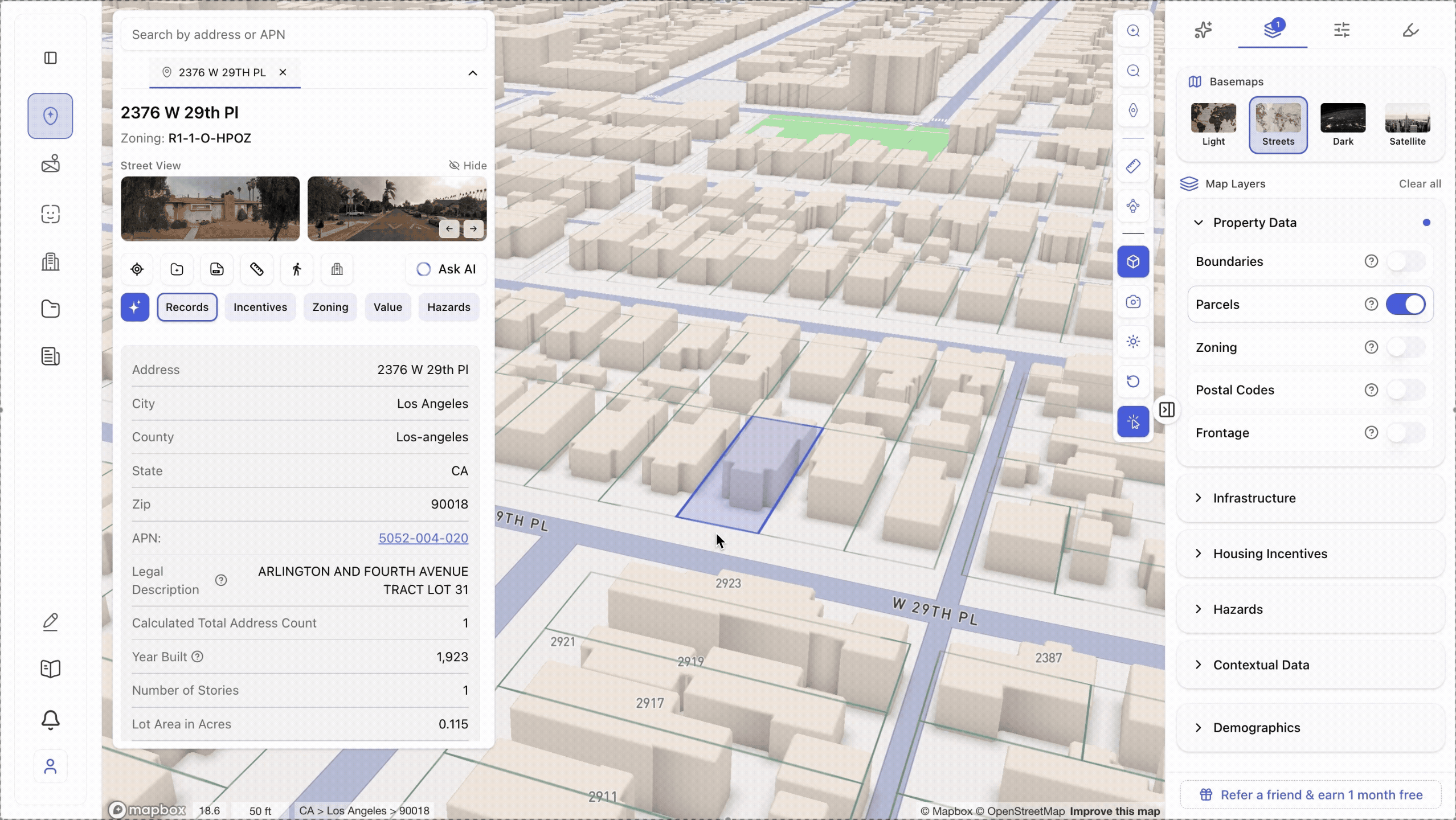
How Archiwise Reads All of This Instantly
The traditional process for one LA parcel: ZIMAS lookup, decode the zoning string, check [Q] conditions in the ordinance record, determine if a Specific Plan applies, pull the plan document, check TOC tier and QCT status separately, call the planning department. Hours for one site. Days for a portfolio.
Archiwise surfaces all of it the moment you click a parcel – pulled from the applicable zoning code, planning documents, and incentive databases for that exact location.
Archiwise has also ingested up to 200 Los Angeles planning documents – specific plans, community plan guidelines, LAMC sections, overlay regulations – into its AI knowledge base. Ask the AI Zoning Expert about any parcel and it draws from the documents that actually govern that piece of land.
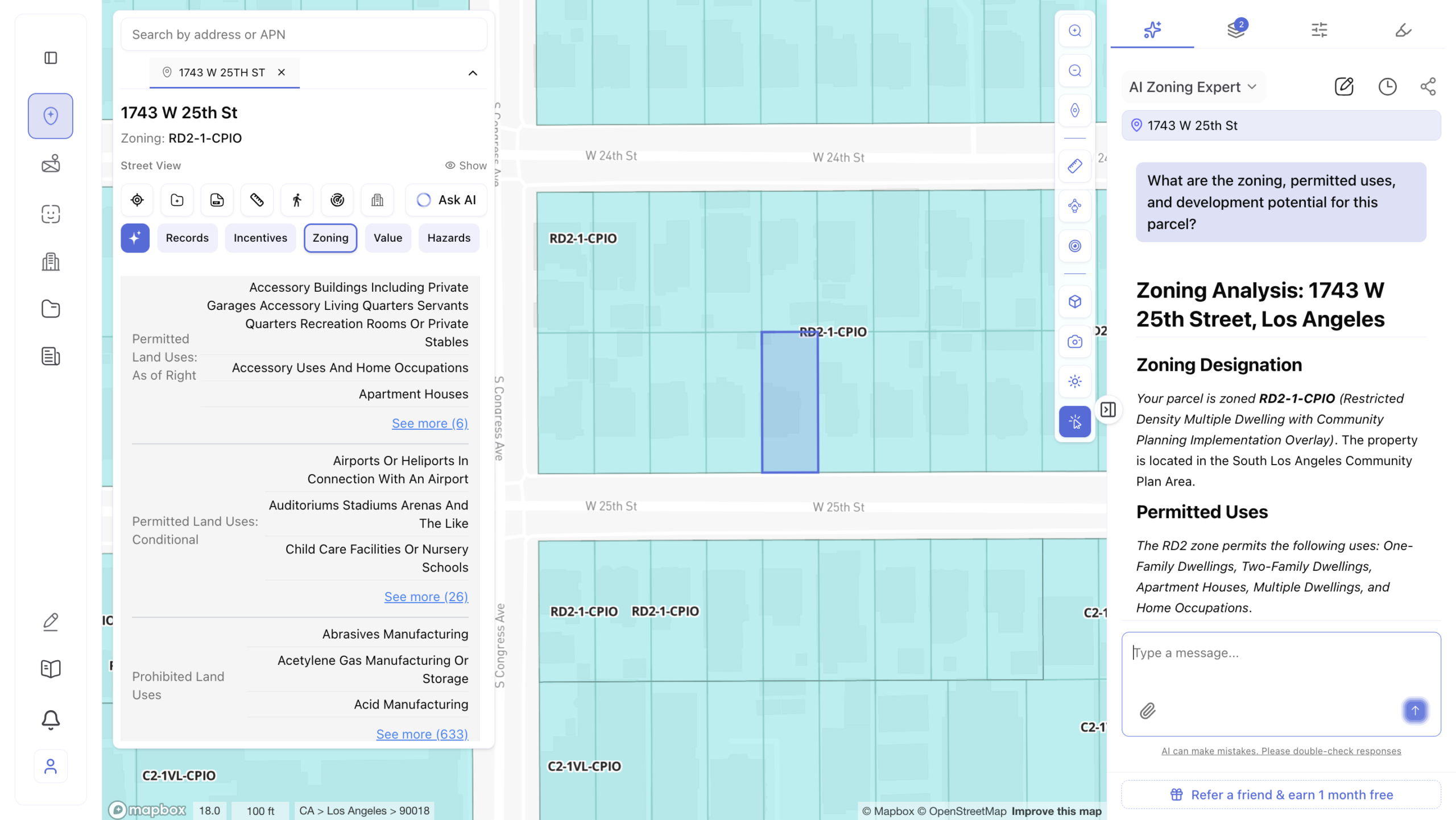
That’s not a generic explanation of what a zone type means. It’s a parcel-specific answer drawn from the planning documents that govern that exact piece of land.
The Developer’s Checklist – Before You Make Any Offer
Zoning basics:
□ Base zone – residential, commercial, or industrial?
□ Height district number – FAR and height limits?
□ [Q] conditions – verified directly from the ordinance?
□ CDO, HPOZ, or other overlay?
□ Specific Plan area?
Development standards:
□ Maximum FAR?
□ Maximum height in feet?
□ Setbacks – front, side, rear?
□ Minimum lot area per dwelling unit?
□ Parking required?
□ Open space required? (6+ units trigger LAMC Section 12.21 G)
Incentives – Archiwise surfaces all of these for any parcel:
□ TOC tier and density bonus?
□ QCT eligible?
□ Nearby LIHTC precedents?
□ DDA (Difficult Development Area) designation?
□ SB79 Transit-Oriented Development eligible?
Entitlement path:
□ Intended use: by-right, conditional, or prohibited?
□ Discretionary review required?
New code:
□ Downtown LA or Boyle Heights (Chapter 1A)? Or original Chapter 1?
The Takeaway
LA zoning rewards the developers who understand it and penalizes the ones who don’t. A single digit in a zoning string. A [Q] condition buried in an ordinance. A Specific Plan that supersedes everything else on the map. These are not edge cases – they happen on every block in every neighborhood.
The developers who win in LA are the ones who know before they offer.
Archiwise puts the full zoning picture – base zone, height district, overlays, [Q] conditions, incentives, hazards, value – in front of you the moment you click a parcel. Drawn from up to 200 LA planning documents. In seconds.
Click any parcel. Know the zone. Make the call.
Explore any LA parcel’s full zoning picture – instantly.
Archiwise surfaces zoning designations, development standards, incentive eligibility, hazard exposure, and AI-powered answers from up to 200 LA planning documents – for any parcel, in seconds.
Learn more
ArchiWise helps developers, investors, architects, and brokers go from address to decision in minutes, not weeks.
Whether you’re screening sites for multifamily development, evaluating zoning constraints, surfacing incentive eligibility like QCT and LIHTC, or assessing hazard risk before committing capital, ArchiWise runs every layer of analysis in one place.
Explore how ArchiWise helps teams screen development sites, analyze zoning, and make confident go/no-go decisions faster.