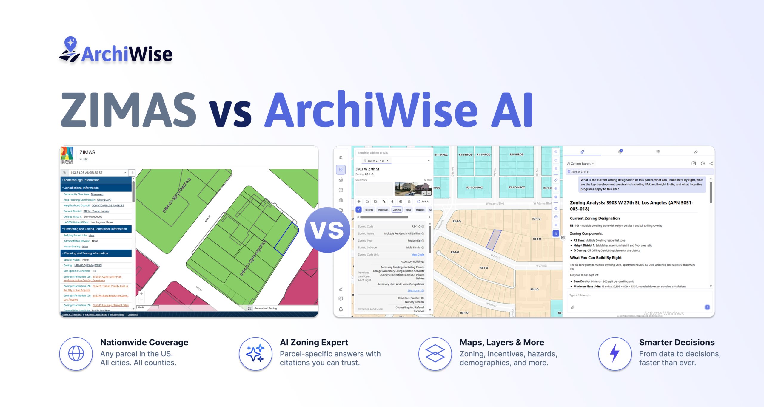
ZIMAS is one of the best free planning tools in the country. Here’s what happens when you need more.
If you develop in Los Angeles, you know ZIMAS. The Zone Information and Map Access System is LA City Planning’s official parcel lookup – free, publicly available, and more capable than most people realize. For any parcel inside Los Angeles city limits it surfaces zoning designations, overlay conditions, incentive eligibility, hazard flags, planning case history, and assessor data. It’s a serious tool.
This article is not an attack on ZIMAS. It’s an honest look at what ZIMAS cannot do – and what that means for developers who need more than a data lookup.
What ZIMAS Actually Does
For any parcel inside LA city limits, ZIMAS surfaces an enormous amount of data across several sections:
- Address and legal information – site address, APN, lot area, tract, map reference, Thomas Brothers grid
- Jurisdictional information – Community Plan Area, Area Planning Commission, Neighborhood Council, Council District, Census Tract, LADBS District Office
- Planning and zoning – base zone, height district, General Plan land use, all overlay conditions ([Q] conditions, CDO, HPOZ, CPIO, RIO, HCR, NSO, POD, and others), Specific Plan area, Historic Preservation Review
- Incentive eligibility – TOC tier, SB 9, SB 35, SB 684, AB 2097, AB 2011, AB 130, Downtown Adaptive Reuse, ED 1, High Quality Transit Corridor, TCAC Opportunity Area, Affordable Housing Linkage Fee, Inclusionary Housing
- Housing policy – RSO status, Ellis Act, Just Cause for Eviction, Housing Crisis Act review, Housing Element replacement requirements, Housing Use within Prior 5 Years
- Assessor information – assessed land value, improvement value, last sale amount, last owner change date, building data (year built, bedrooms, bathrooms, square footage), deed reference numbers
- Additional Information – Airport Hazard, Coastal Zone, Very High Fire Hazard Severity Zone, Flood Zone, Methane Hazard Site (Methane Zone / Methane Buffer Zone / None), High Wind Velocity Areas, Wells, Sea Level Rise Area, Oil Well Adjacency, and more
- Environmental – Biological Resource Potential, Mountain Lion Potential, WUI, USFWS-designated CHAs, and others
- Seismic Hazards – nearest fault name and distance, fault type, slip rate, slip geometry, rupture parameters, dip angle, maximum magnitude, Alquist-Priolo status, liquefaction, landslide, tsunami hazard area
- Economic Development Areas – Opportunity Zone, Hubzone, JEDI, Promise Zone, State Enterprise Zone
- Public Safety – police bureau, division, reporting district, fire information
- Case Numbers – every CPC, ORD, and ENV case tied to the parcel, going back
ZIMAS is a web-based mapping application developed by LA City Planning. Chapter 1A of the LAMC – the new zoning code – went into effect in early 2025 and applies to the Downtown Community Plan Area and subsequent updates. ZIMAS is actively maintained and free.
The problem is the first four words of that sentence: built for Los Angeles.
What ZIMAS Cannot Do
ZIMAS is exceptional at what it was built for. But there are clear boundaries.
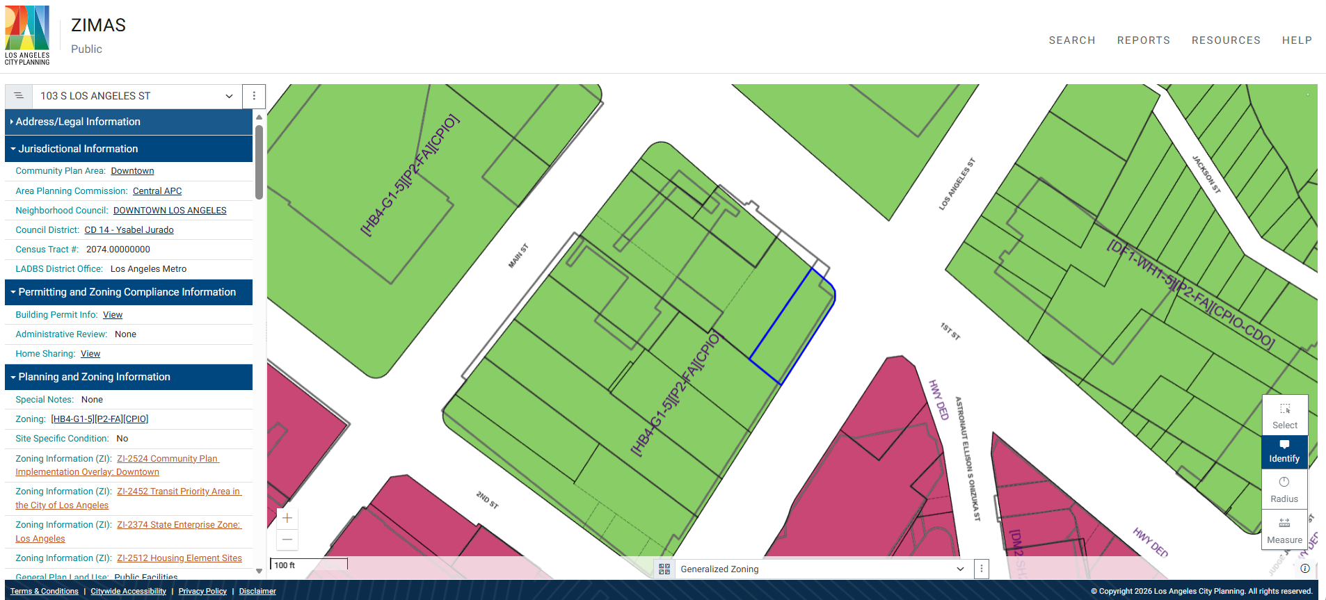
It only covers the City of Los Angeles.
Not LA County. Not Culver City, Santa Monica, Long Beach, Glendale, Pasadena, Burbank, or any of the 87 other incorporated cities in LA County. Let alone the rest of California or the United States. The moment a site falls outside LA city limits, ZIMAS stops entirely.
It doesn’t show the underlying zoning controls.
ZIMAS shows the zone code and height district – for example, R1-1, Height District 1 – but not FAR, exact height limit, setbacks, lot coverage, density, or parking requirements. You need to cross-reference the zoning code tables separately to find them.
It doesn’t answer development questions.
ZIMAS explains what designations mean – click any field and a popup describes the regulation, who it applies to, and where to get more information. That’s useful context.
But context is not a decision. You see zoning [DF1-WH1-5][P2-FA][CPIO-CDO]. ZIMAS cannot answer: “Given this zoning, can I build 80 units of workforce housing here, and what approvals would I need?” It cannot calculate how many units a specific lot size supports, what incentive programs stack on top, or what the entitlement path looks like. There is no AI chat. There is no parcel-specific reasoning.
It looks up one parcel at a time.
No multi-parcel comparison. No assemblage analysis. No way to evaluate three adjacent lots simultaneously or understand what a combined site could support.
It withholds ownership data publicly.
Owner name and mailing address are labeled “Not Available on Internet version of ZIMAS” – accessible only to LA city staff via the internal intranet.
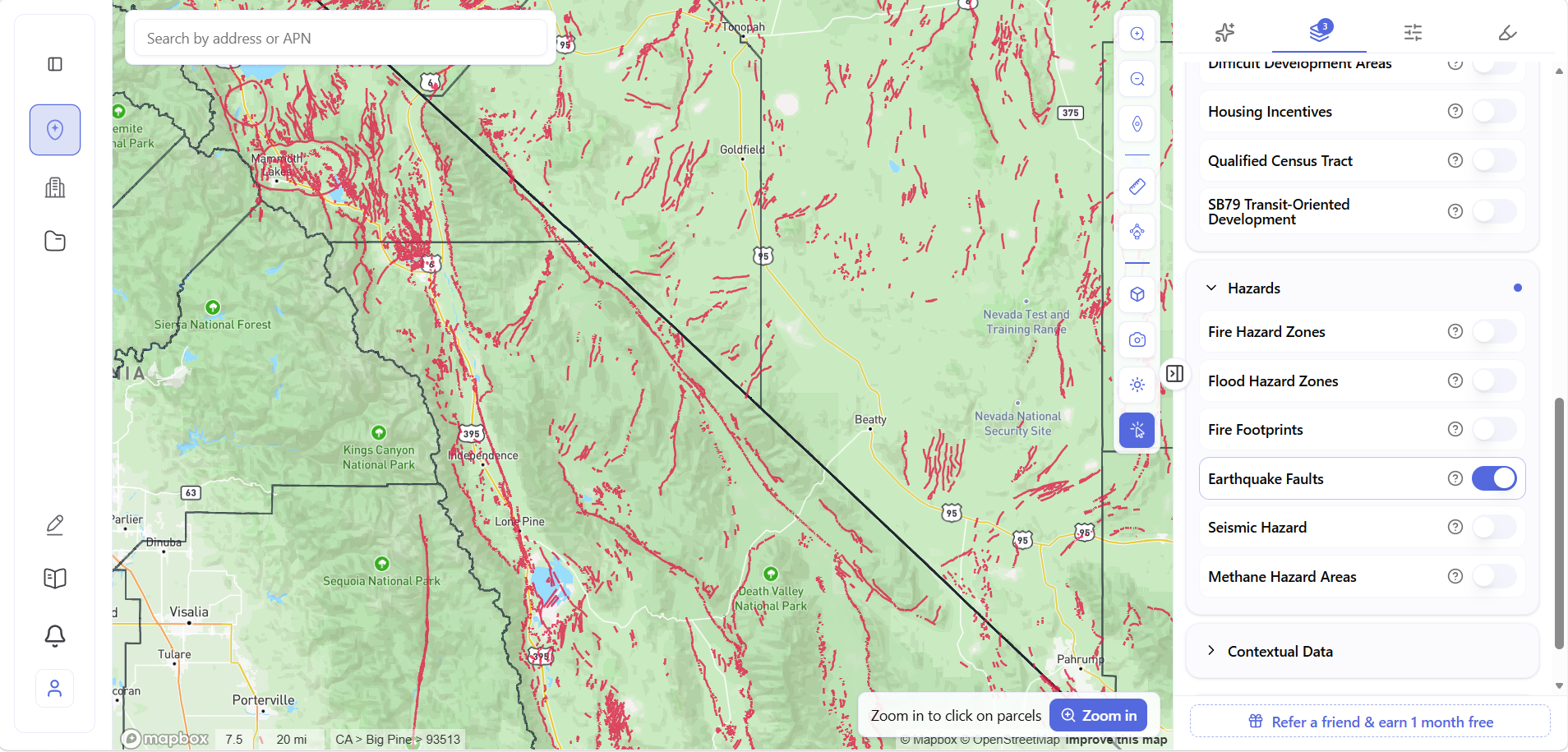
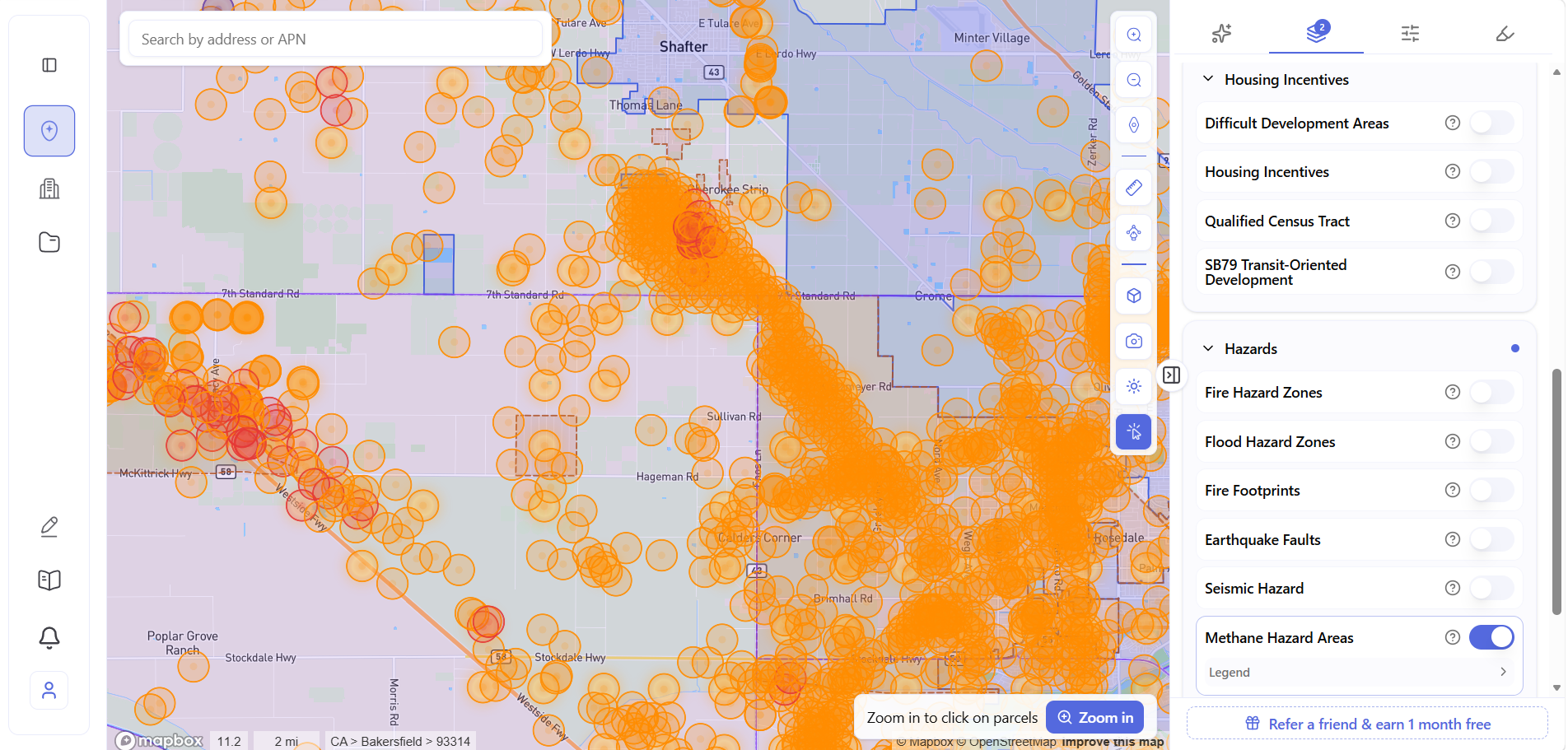
It has no map layers for hazards, demographics, or infrastructure.
Hazard data appears as text fields in the parcel report – no visual layer showing which surrounding parcels are in a methane zone, fire hazard zone, or flood zone. No demographics. No gas pipelines, electricity lines, or sewer lines on the map.
What Archiwise Is
Archiwise is a pre-development research platform built for developers, investors, and architects – covering any parcel in the United States.
Click any parcel and an info modal opens with nine data tabs: Records, Incentives, Zoning, Permits, Value, Comps, Hazards, Ownership, and Demographics
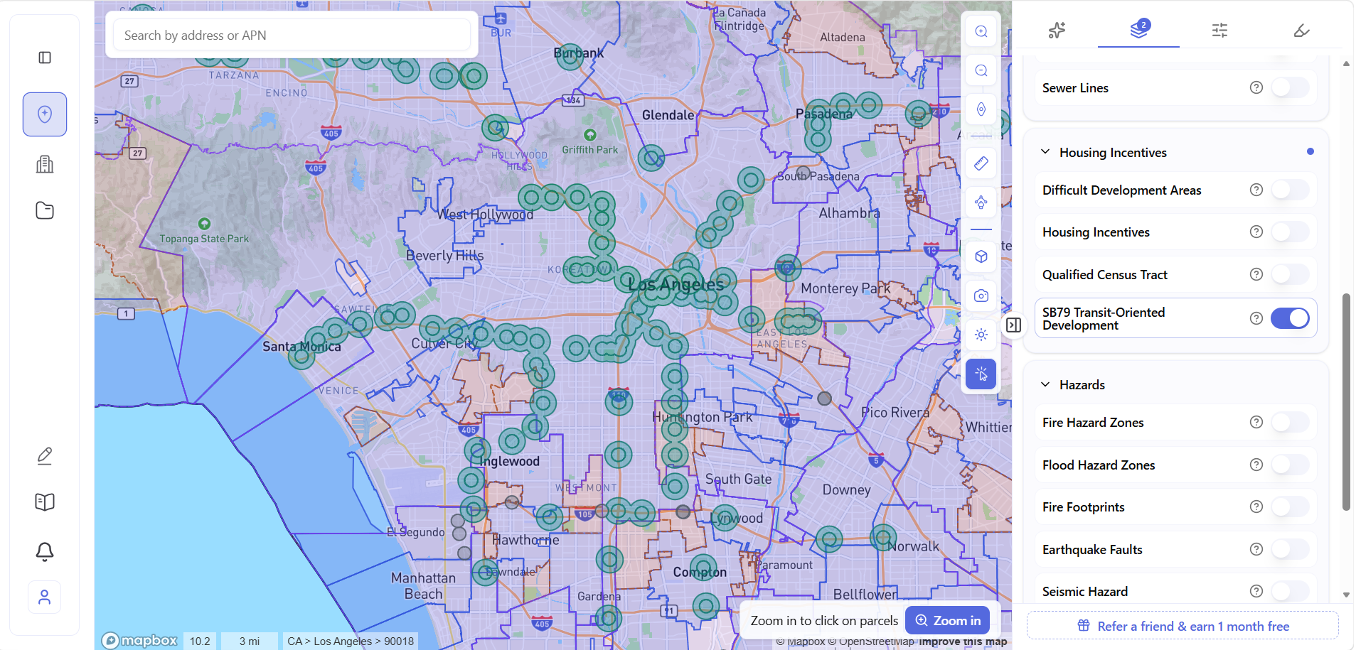
On the map, toggleable layers surface data across entire regions before you’ve clicked a single address – Six layer categories: Property Data, Infrastructure, Housing Incentives, Hazards, Contextual Data, and Demographics. The two work together: the map shows you where to look, the parcel panel tells you what you’re looking at.
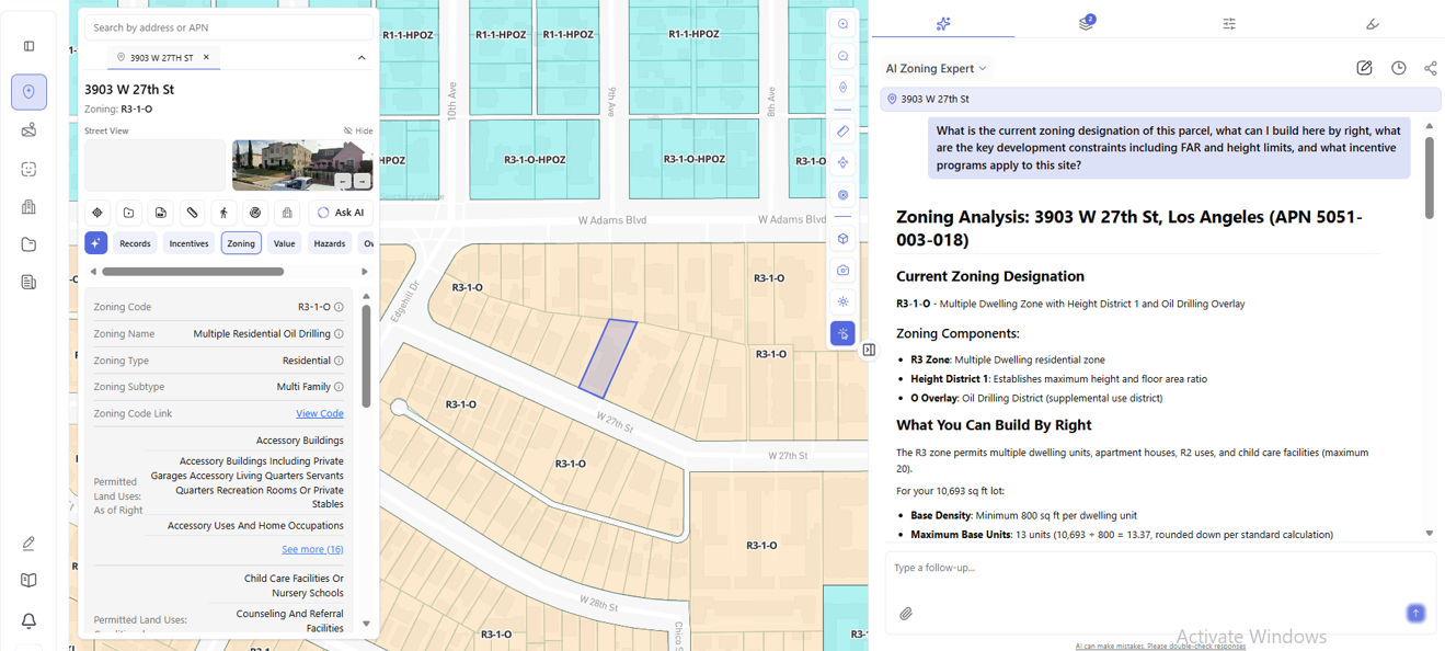
Zoning – The Full Picture, Any City
Like ZIMAS, Archiwise surfaces the zoning code and overlay conditions. Unlike ZIMAS, it also pulls the underlying zoning controls – FAR, height limit, setbacks, lot coverage, density, parking – directly into the parcel panel, for any parcel in the US.
The Zoning tab shows permitted uses as three explicit lists: as of right, conditional, and prohibited. That three-way breakdown is the difference between knowing a parcel’s zone code and understanding what you can actually do with the land. And alongside the parcel panel, the AI Zoning Expert answers development questions for that specific address – drawing from the applicable zoning code, specific plan, general plan, other planning documents and state legislation, with numbered source citations in every answer.
Incentives – Automatically Screened, Nationwide
ZIMAS covers incentive eligibility for LA parcels in detail. TOC tier is shown as a text field. For state legislation – SB 9, SB 35, SB 684, AB 2011, AB 130 – clicking “View” opens a full parcel-specific eligibility checklist, walking through every criterion with Yes/No answers for that address. That’s genuinely useful for LA developers working within the city.
Two things it cannot do.
First, it only covers LA. Cross a city boundary and all of that disappears. A parcel in Glendale, Long Beach, or anywhere outside LA city limits gets nothing.
Second, ZIMAS has no data on SB 79 – California’s Transit-Oriented Development law signed in October 2025 and in effect from July 2026. For one of the most significant housing incentive programs active in California right now, ZIMAS shows nothing.
Archiwise screens incentive eligibility for any parcel in the US – automatically, without clicking through separate checklists. The SB 79 layer shows eligible Transit-Oriented Development areas by tier and exact distance from transit across California. TOC tier, QCT status, DDA designation, and LIHTC precedents surface in the Incentives tab for any parcel, any city.
And the AI Zoning Expert answers eligibility questions directly – which programs apply to this parcel, what each one unlocks, and how stacking multiple incentives affects the project.
Hazards – LA Only vs Everywhere
ZIMAS surfaces hazard information for LA parcels as text fields in the parcel report – seismic data, fire hazard severity zone, flood zone, methane hazard site designation, and more. Click any field and a popup explains what it means. That’s genuinely useful for LA parcels.
But there is no map layer. You get a text report for one parcel at a time – no visual showing how hazard zones distribute across a corridor, no way to see which adjacent parcels are affected, no regional picture before you’ve clicked.
And it’s LA only. The moment a site is in Long Beach, Glendale, or any city outside LA limits, all of that data disappears.
Archiwise surfaces hazard data as both parcel-level detail and interactive map layers – for any parcel in the US. Six layers: Fire Hazard Zones, Flood Hazard Zones, Fire Footprints, Earthquake Faults, Seismic Hazard, and Methane Hazard Areas. Toggle any layer and the risk picture appears across an entire region before you’ve opened a single parcel panel.
The AI Answers. ZIMAS Doesn’t.
ZIMAS has no AI. It surfaces the data and the definitions – what you do with them is your job.
Archiwise’s AI Zoning Expert is built on a large RAG system – trained on thousands of planning documents including zoning codes, specific plans, general plans, community plans, overlay ordinances, state legislation, and local guidelines from cities and counties across the United States. When you ask a question about a parcel, the AI draws from the documents that actually govern that jurisdiction – not general knowledge, but the specific planning documents that apply to that address.
Every answer includes numbered source citations linking directly to the governing planning documents. You can see exactly where the answer comes from.
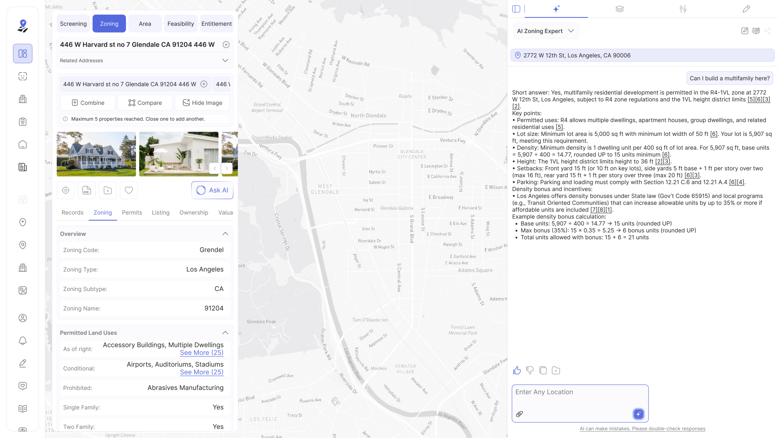
Ask it “Can I build a multifamily here?” and it returns a direct answer – base unit calculation using the actual parcel square footage, applicable incentive programs and their effect on unit count, what is by right versus what triggers discretionary review, and the specific code sections cited. The answer for a parcel in Glendale is as specific and cited as the answer for a parcel in Los Angeles, Denver, or Houston – because the planning documents for each jurisdiction are in the system.
Data and Capabilities ZIMAS Doesn’t Have
Infrastructure – gas pipelines, electricity lines, and sewer lines on the map. Information that otherwise requires calls to three separate utility companies before you’re even in contract.
Demographics – median household income, population density, median rent, rent burden, homeownership rate, age distribution, education levels, poverty rate, labor force participation, unemployment rate, and six-figure household concentration. All as map layers, all visible at the parcel level.
Ownership – owner name, ownership type, and mailing address in the Ownership tab. ZIMAS’s public internet version labels these “Not Available on Internet version of ZIMAS.” Archiwise shows it for any parcel in the US – the difference between knowing a parcel exists and being able to reach the person who owns it.
Multi-parcel analysis – Archiwise supports up to five parcels simultaneously, shows combined lot area, total value, and land vs improvement breakdown – then lets you ask the AI about the assemblage directly.
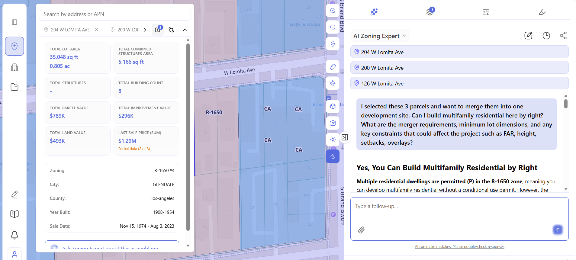
The AI answer covers whether multifamily is permitted by right, merger requirements, minimum lot dimensions, and what constraints could affect the project – for the combined site, with the governing code cited. ZIMAS has no equivalent.
Site Screening – Finding Sites Before You Know the Address
ZIMAS has no site screening tool. You need to know an address before you can look anything up.
Archiwise has a Draw Search Area tool – draw a custom polygon on the map and filter every parcel within it. The full filter set:
Parcel Details – lot size, frontage, corner parcels only, year built, vacancy status, USPS vacancy, Residential Delivery Indicator
Current Use – residential buildings, commercial buildings, public assembly structures, institutional or community facilities, transportation-related facilities, utility and other nonbuilding structures, specialized military structures, sheds and farm buildings
Value, Ownership, Zoning – filter by assessed value range, ownership type, and zoning designation
Location and Proximity – find parcels within actual drivable or walkable distance from any point of interest, not a radius circle
Demographics – screen by the demographic characteristics of the surrounding area
For a developer sourcing off-market sites across a corridor – infill lots above a certain size, vacant parcels in a specific zoning category, sites within walking distance of a transit station – this replaces hours of manual research. ZIMAS cannot do any part of it.
Head-to-Head
| Zoning controls (FAR, height, setbacks, lot coverage, density, parking) | ✗ not shown | ✓ Any US parcel |
| Permitted / conditional / prohibited uses | ✓ LA only | ✓ Any US parcel |
| Incentive screening (TOC, SB9, SB35) | ✓ LA only | ✓ Any US parcel |
| SB 79 Transit-Oriented Development | ✗ no data | ✓ Any CA parcel, by tier and distance |
| Hazard data | Text flags + seismic detail, LA only | Map layers + parcel detail, any US parcel |
| Assessed value / last sale | ✓ LA only | ✓ Any US parcel |
| Ownership data (name + address) | ✗ withheld publicly | ✓ |
| Demographics | ✗ | ✓ |
| Infrastructure layers | ✗ | ✓ |
| Multi-parcel comparison | ✗ | ✓ up to 5 parcels |
| Assemblage AI analysis | ✗ | ✓ |
| Parcel-specific AI with citations | ✗ | ✓ |
| Isochrone search | ✗ | ✓ |
| Planning history | ✓ LA only | ✗ |
| Cost | Free | Paid |
The Bottom Line
ZIMAS is a remarkable free tool. For LA, within LA, it covers an enormous amount of ground – zoning, incentives, hazards, assessor data, planning history going back decades. If you work exclusively in Los Angeles city limits and can interpret the data yourself, it may be all you need.
But the moment a site crosses a city boundary, ZIMAS stops. And the moment you need a decision rather than a data point – how many units, what approvals, what incentives stack, whether the numbers work – it has nothing to offer.
Archiwise picks up where ZIMAS leaves off. Any parcel in the US. Every pre-development question answered by the AI Zoning Expert, with the governing planning documents cited.
Learn more
ArchiWise helps developers, investors, architects, and brokers go from address to decision in minutes, not weeks.
Whether you’re screening sites for multifamily development, evaluating zoning constraints, surfacing incentive eligibility like QCT and LIHTC, or assessing hazard risk before committing capital, ArchiWise runs every layer of analysis in one place.
Explore how ArchiWise helps teams screen development sites, analyze zoning, and make confident go/no-go decisions faster.