

The real difference between manual parcel screening and AI site selection isn’t speed. It’s where the process starts – and what it can find.
Most developers research sites the same way: start from an address, work through a sequence of portals and databases, and hope the picture comes together before someone else makes an offer.
That process has a structural problem that no amount of efficiency solves. It starts from an address. Which means it can only evaluate sites someone has already surfaced – a broker, a listing, a tip. The parcel that’s been held for 25 years by a corporate owner who’s never been approached, in a zone with incentive potential, assessed well below what it could support: that site doesn’t have an address to start from. So it never gets researched.
This is the core difference between manual parcel screening and AI site selection. Not that AI is faster – though it is. But that it starts from criteria, not addresses. And that changes what’s findable entirely.
The Problem with Manual Parcel Screening
Where the Time Goes
Manual parcel screening breaks down into a predictable sequence of steps, each with its own portal, its own format, and its own failure mode.
Step 1 – Find a candidate site. Usually requires a known address from a broker, a listing, or local knowledge. Off-market opportunities require canvassing, relationships, or luck. There is no systematic way to screen a whole market without an address to start from.
Step 2 – Look up the zoning. Navigate to the city or county planning portal. Find the parcel. Identify the zoning designation. Pull up the applicable code section. Cross-reference height districts, overlay conditions, and any [Q] restrictions. For a site with stacked conditions, this alone can take hours.
Step 3 – Check hazard exposure. Fire hazard severity, flood zone, seismic data, methane risk – each sitting in a different agency portal with a different interface and a different data format, with no way to see how hazards intersect on a single parcel.
Step 4 – Screen incentive eligibility. Check TOC tier on one map. QCT status on a separate federal database. DDA designation on another. State programs across separate pages. No single source, no single check.
Step 5 – Find the owner. County assessor portal. One APN at a time. Often shows a name but not a mailing address. No signal on likelihood to sell. Paid data pulls or title company queries for anything beyond basics.
Step 6 – Run the numbers. Pull assessed value, last sale price, improvement value. Manually. One parcel at a time.
For a single site, this process takes the better part of a day. For ten candidate sites, it takes most of a week. And most of those sites won’t work – which means most of that time is spent on research that produces a no.
“Manual screening makes the no as expensive as the yes. Hours of research per site, most of which don’t work – and the ones that do were already known to competitors.”
The Address-First Constraint
The deepest structural problem with manual screening isn’t the time it takes – it’s where it has to start. Manual research requires a known address. You can’t screen a market without one. You can’t set criteria and get back a list of matching parcels. You can’t find a site that no one has told you about yet.
This means manual screening is reactive by design. A broker calls. A listing appears. The developer reacts. The off-market opportunity – the underutilized parcel, the long-held property, the institutionally-owned site in the right zone – stays invisible because no one thought to look at a specific address.
What Gets Missed
The practical consequence of address-first, step-by-step manual research is a category of opportunity that essentially never surfaces.
Underutilized parcels with low improvement value relative to land value – classic redevelopment candidates that don’t appear on any listing. Long-held properties whose owners have never been approached because no one knew to look for them. Government-owned or institutionally-held parcels that could be acquired but require knowing they exist and who to contact. Incentive-eligible sites in QCT or TOC zones where a project pencils specifically because of the designation – but only if you know the designation exists before you start underwriting. Hazard-free corridors in otherwise risky areas, visible only when you can see hazard data across a whole neighborhood rather than one parcel at a time.
None of these surface through manual screening. They require the ability to set criteria and search, rather than start from an address and research.
Introducing ArchiWise
ArchiWise is a nationwide pre-development intelligence platform covering every parcel in the United States, built for developers, architects, and brokers working infill and multifamily projects. It combines four capabilities into one workflow: ArchiWise AI, a single conversational interface that answers every pre-development question for the parcel you’re asking about, grounded in the actual planning documents governing it and cited to the exact code section it came from, and can also find and filter parcels across an entire market by chat; Area Intelligence layering hazards, infrastructure, incentives, and demographics from authoritative federal, state, and local sources onto the same map; Feasibility Analysis delivering massing, program, and pro forma in a six-step generative workflow powered by the AI Visualizer; and Entitlement Viability scoring approval risk based on real project outcomes tracked by jurisdiction and project type.
Clicking any parcel opens nine data tabs – Records, Incentives, Zoning, Permits, Tax, Comps, Hazards, Ownership, and Demographics – assembling in seconds the picture that manual research takes days to piece together.
The comparison that follows isn’t AI versus manual in the abstract. It’s ArchiWise versus manual – specific tools, specific workflows, specific outputs at each step.
One Chat, Not Five Separate Tools
ArchiWise AI answers every pre-development question in the same conversation – from zoning to site selection. Ask it a plain-language zoning question about a parcel you’ve clicked, and it reasons through that parcel’s actual planning documents, citing the section. Ask it to find parcels across an entire market instead, and it applies filters the same way the panel would. There’s no separate assistant behind a different tab for a different kind of question – one chat, whatever you’re asking. (See Step 1 below for what that looks like on a real search.)
Step by Step: Manual vs ArchiWise
Step 1 – Finding candidate sites
Manual: Compile addresses from brokers, listings, local knowledge. Off-market opportunities require canvassing or relationships. No systematic way to search a market without a known address.
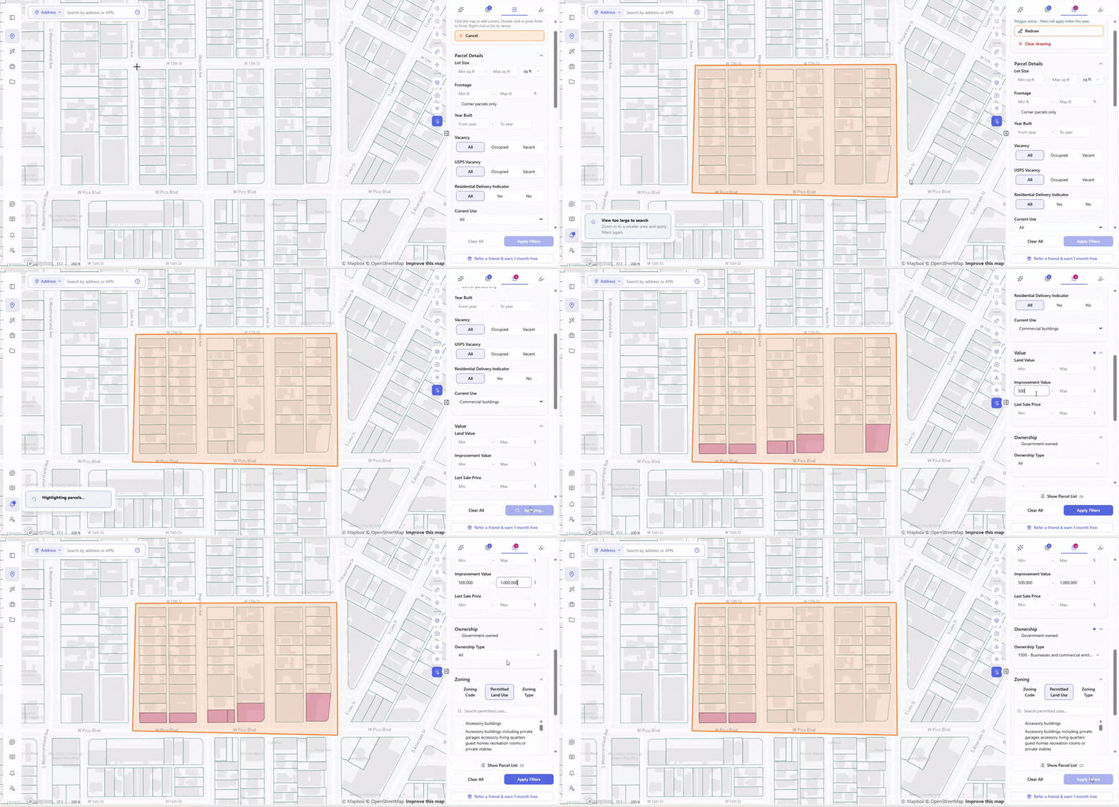
With ArchiWise: Use the Draw Search Area tool to define your target market on the map. Then open the filter panel and stack your criteria – lot size, frontage, year built, vacancy status, current use, improvement value, ownership type, zoning, location, proximity, demographics. Hit Apply Filters and the map instantly narrows to only the matching parcels inside your drawn area. No address required. Off-market parcels surface the same way listed ones do.
On a real search along W Pico Blvd, Los Angeles: draw the area, apply Current Use: Commercial, and the count comes back at 6 parcels. Stack Improvement Value $500K–$1M and Ownership Type: 1500 – Businesses and commercial entities on top of that, and the list narrows to 2 parcels – both meeting every criterion, both invisible to a search that starts from an address instead of a buy box. Open the Parcel List and both appear, ready to export or add to a project.
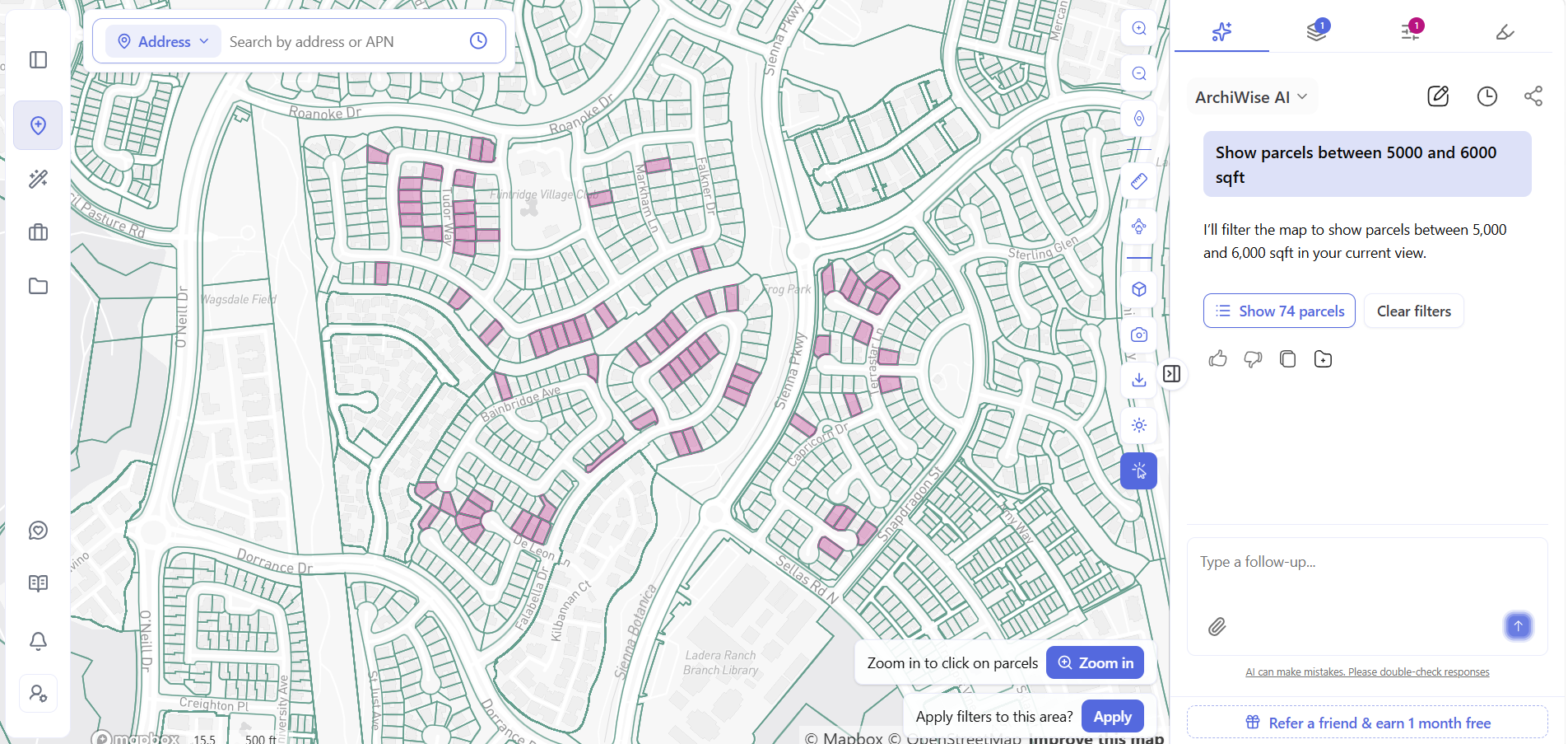
The same search also works by chat. Skip the filter panel entirely and just describe what you’re looking for to ArchiWise AI – the same chat that answers zoning questions sets these filters too. Type something like “show parcels between 5,000 and 6,000 sqft,” and it doesn’t just describe what that search would return – it applies the filter to your current map view and hands back the real number. On one real search, that came back as 74 matching parcels, shaded directly on the map, with a Clear Filters option one click away. Swap in a value range, an ownership type, or a zoning designation instead of square footage, and it stacks the same way – just typed instead of clicked.
Step 2 – Zoning research
Manual: Navigate to the city or county planning portal. Find the parcel. Identify the zone. Pull the applicable code section. Cross-reference height districts, overlays, [Q] conditions. For a stacked site, this takes hours.
With ArchiWise: Click the parcel. The Zoning tab surfaces permitted uses, conditional uses, prohibited uses, FAR, height limits, setbacks, lot coverage, density, and parking requirements instantly – with a direct link to the applicable code. ArchiWise AI answers follow-up questions in plain language, with every figure cited to the exact code section it came from.
Step 3 – Hazard screening
Manual: Fire hazard severity, flood zone, seismic data, and methane risk each require a separate agency portal with a different interface and format. No way to see how hazards intersect on a single parcel. Typically discovered during due diligence – after earnest money is committed.
With ArchiWise: The Hazards tab surfaces fire hazard zone status, flood zone designation, seismic rating, methane risk, past wildfire history, and fault proximity simultaneously – the moment a parcel is clicked, before any commitment is made.
Step 4 – Incentive eligibility
Manual: Check each program separately – TOC tier, QCT status, DDA designation, and state programs across different databases and agency portals. No single source covers all of them.
With ArchiWise: The Incentives tab screens automatically against TOC tier, QCT status, DDA designation, SB 9, SB 35, SB 79, AB 2011, and nearby LIHTC precedents – all in one click, the moment a parcel is opened.
Step 5 – Ownership research
Manual: County assessor portal. One APN at a time. Often shows a name but not a mailing address. No signal on likelihood to sell. Paid data pulls for anything beyond basics.
With ArchiWise: Owner name, ownership type, and mailing address surface instantly. Every parcel shows a hold period and a Sell Candidate rating – from Weak to Very Strong – so the developer knows not just who owns the site but how likely they are to sell, before making contact. Click Load Owner Contacts for phone numbers and email addresses where available.
Step 6 – Value and comps
Manual: Pull county assessor records manually. One parcel at a time. Comp research requires a separate process.
With ArchiWise: Assessed land value, improvement value, last sale price, and sale date appear instantly on the Value tab. The Comps tab surfaces comparable properties from the same assessor records.
The Ownership Signal Manual Research Misses
Of all the differences between manual and ArchiWise screening, the ownership dimension is the most consistently overlooked – and the most valuable for off-market deal flow.
Manual ownership research answers one question: who owns this specific parcel? That requires knowing the address already, produces a name that may or may not come with a mailing address, and gives no signal about whether the owner is actually likely to sell.
ArchiWise turns ownership into a proactive screening dimension. Filter directly by Government-owned parcels, or open the Ownership Type field and choose from the full checklist of numbered codes – private persons, private trusts, businesses and entities, nonprofit ownership by subtype, and more. Every matching parcel in the filtered results includes owner name, mailing address, hold period, and Sell Candidate rating – before any contact is made.
Real example: 2317 W Pico Blvd, Los Angeles – zoning [Q]C2-2
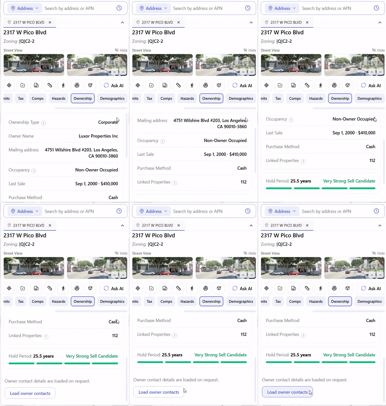
This parcel surfaced through exactly the kind of criteria-first filter described above. Open the Ownership tab and the signal is immediate: Ownership Type: Corporate. Owner Name: Luxor Properties Inc. Mailing address: 4751 Wilshire Blvd #203, Los Angeles, CA 90010-3860 – different from the site address, confirming non-owner occupied. Last Sale: Sep 1, 2000 · $410,000, purchased in cash. Linked Properties: 112 – a portfolio holder, not a single-asset owner. Hold Period: 25.5 years – flagged Very Strong Sell Candidate.
Twenty-five years in the same hands. A corporate owner with 112 linked properties whose mailing address is across the city. A cash purchase in 2000 that has never been revisited. This is the kind of ownership picture that manual research – starting from a county portal, one APN at a time – would take hours to piece together. In ArchiWise it’s visible the moment the tab opens.
The Full Picture: What Clicking One Parcel Shows
Once a parcel is flagged through the filter – criteria met, ownership signal confirmed – clicking it opens the complete pre-development picture in one view.
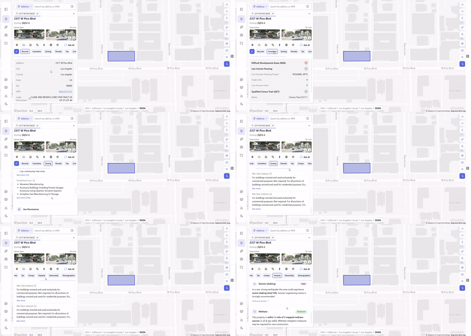
For 2317 W Pico Blvd, [Q]C2-2, the nine tabs surface immediately. The Records tab confirms the address, APN (5076-017-012), legal description, and parcel basics. The Incentives tab shows the full program picture at a glance: Difficult Development Area: not eligible; Low Income Housing: eligible – nearby ROSAMEL APTS (9 total units, 9 low income units) confirms the financing pathway works in this neighborhood; Qualified Census Tract (QCT): eligible – Census Tract 2211.1 – unlocking a 30% LIHTC basis boost on any affordable project. The Zoning tab surfaces the full [Q]C2-2 picture – the Qualified condition, commercial base zone, permitted and conditional uses, FAR, height, setbacks, and parking – with a direct link to the applicable code.
The Hazards tab delivers the complete risk picture without a single separate agency search. Fire hazard zone: Clear – not in a designated fire hazard severity zone. Flood: Clear – FEMA Zone X, minimal flood hazard, insurance typically not required. Seismic: High – severe shaking level VIII in a rare strong earthquake; seismic engineering review strongly recommended. Methane: Moderate – within ½ mile of 3 mapped methane sources; mitigation measures required. Past wildfires: Clear – no recorded wildfire has burned this parcel since 2010. Earthquake faults: Moderate – a mapped fault runs within about ⅔ of a mile (Lower Elysian Park thrust, nearest trace ~0.5 mi); a site-specific fault study may be required.
That’s six hazard dimensions surfaced simultaneously – fire, flood, seismic, methane, wildfire history, fault proximity – that manual research would require six separate agency searches to assemble.
What This Means for Deal Flow
The practical consequence of criteria-first screening isn’t just that individual sites get researched faster. It’s that the pipeline itself changes.
More sites evaluated. A developer who can screen dozens of parcels in the time manual research takes for one evaluates more opportunities, ranks them faster, and focuses professional time on the ones that actually work.
Earlier in the cycle. Criteria-first screening finds sites before they’re listed – before brokers are involved, before competing offers appear, before the owner has any reason to think about selling. The off-market advantage is structural, not lucky.
Better-informed offers. A developer who goes into a negotiation knowing the zoning, hazards, incentive eligibility, ownership history, and assessed value is negotiating from a fundamentally different position than one who found out two of those things.
Fewer late surprises. Hazard exposure, overlay conditions, and entitlement complexity that surface during due diligence – after earnest money is committed – are the most expensive discoveries in development. Criteria-first screening surfaces them during screening, when the cost of walking away is zero.
The Bottom Line
The difference between manual parcel screening and AI site selection isn’t a matter of doing the same thing faster. It’s a matter of what can be found at all.
Manual screening starts from an address. That constraint means it can only evaluate sites that have already been surfaced – listed, brokered, or mentioned. The underutilized parcel held for 25 years by a corporate owner with 112 linked properties, sitting in a QCT zone, with a mailing address across the city: that site stays invisible because nobody knew to filter for it.
Criteria-first screening in ArchiWise finds that parcel. It finds it before anyone else looks, before any listing exists, and with the full picture – zoning, hazards, incentives, ownership, value – assembled before any money is committed.
The developers pulling ahead right now aren’t researching harder. They’re starting from a better-informed position – earlier, with more sites evaluated, and with the picture complete before any money is committed.
Stop starting from addresses someone else gave you. Screen your entire target market against your exact buy box – zoning, ownership, value, hazards, and incentives – and find the sites worth pursuing before anyone else does.