

Finding the right land for development is one of the hardest parts of real estate acquisition.
The challenge isn’t simply finding vacant land. A viable development site has to meet a much longer list of requirements: the right location, lot size, zoning, permitted uses, current use, ownership profile, market conditions, development potential, incentives, environmental conditions, and the economics of the intended project.
And some of the best opportunities aren’t listed for sale.
If you’re looking for off-market land, unlisted development sites, redevelopment opportunities, or properties with land-assembly potential, the traditional approach can be painfully slow. You search listings, review broker offerings, open county assessor records, inspect parcel maps, research zoning, analyze demographics, investigate hazards, look for incentives, study ownership, and manually compare one property against another.
Doing that for one property is possible.
Doing it across an entire market is another problem.
The real challenge isn’t finding parcels.
It’s finding the right development sites before everyone else does.
The Hard Part Isn’t Finding Parcels. It’s Selecting the Right Sites.
A developer rarely starts with a perfect address.
More often, the search begins with an investment thesis or a set of site selection criteria. A developer may start with a target city, metro, neighborhood, or development corridor, then define the characteristics of the sites they want to find.
That could include a minimum and maximum lot size, preferred zoning and permitted uses, vacancy or redevelopment potential, ownership characteristics, and a target property value. The search may also depend on proximity to transit, employment centers, or other strategic locations, as well as demographic and market conditions that support the intended development strategy.
Environmental and physical conditions can be just as important. A developer may want to identify areas with development incentives while screening for flood risk, wildfire exposure, or other environmental constraints. Infrastructure and surrounding development can provide additional context when evaluating whether a location makes sense. In some cases, the opportunity may also depend on whether adjacent parcels could be assembled to create a larger development site.
The problem is that these criteria rarely exist in one place.
Parcel and property records may come from an assessor or county GIS system. Zoning information may require searching a municipal planning portal or reading an ordinance. Hazard information can come from separate government datasets. Demographics, incentives, infrastructure, ownership, and market information may require still more research.
The result is a fragmented land acquisition workflow.
You don’t just have to find the land.
You have to reconstruct the story of the land.
That is why many development searches become address-first searches:
Find a property → Research it → Decide whether it works
But this approach has a limitation. You’re only researching properties that have already come onto your radar.
A better approach reverses the process:
Define what a good development site looks like, then find the parcels that match.
That is the fundamental idea behind modern real estate site selection.
From Parcel Search to Market-Wide Site Selection
Modern pre-development intelligence platforms can help developers move from market discovery to site selection and, ultimately, evaluate whether a property is worth pursuing.
Instead of opening one parcel at a time, developers can begin with an entire market and analyze the conditions that matter to their development strategy.
Instead of manually checking hundreds of properties, they can apply land screening criteria across a defined search area.
And instead of treating parcel data, zoning, hazards, incentives, demographics, infrastructure, ownership, and market conditions as separate research projects, they can evaluate these factors together.
The workflow changes from:
Find a property → Research it → Decide if it works
to:
Understand the market → Define the criteria → Find matching sites → Investigate the best candidates
This distinction is important.
Site selection happens before detailed due diligence.
The goal isn’t to fully underwrite every parcel in the market. The goal is to identify which locations and properties deserve deeper attention.
That is where AI Site Selection becomes particularly valuable. Rather than relying only on properties currently listed for sale, developers can use development criteria to search for listed and unlisted opportunities across a market.
How ArchiWise Helps Developers Find Land for Development
ArchiWise is a pre-development intelligence platform designed to help developers and investors research markets, perform site selection, screen parcels, evaluate ownership, and investigate development potential.
The platform brings property, zoning, hazards, incentives, demographics, infrastructure, ownership, and market intelligence into an interactive map, helping development teams understand an area before narrowing down to individual properties.
Its parcel view then brings together property-level information including Records, Incentives, Zoning, Permits, Value, Comps, Hazards, Ownership, and Demographics.
This means the first question doesn’t have to be:
“What do I know about this property?”
It can be:
“Where in this market should I be looking?”
Once the search area is identified, the acquisition process becomes much more systematic.
The 5-Step Land Acquisition and Site Selection Workflow
Step 1: Choose Where to Search
Before selecting a parcel, determine where the market conditions support your development strategy.
This is the first stage of site selection, and it is often overlooked.
A developer looking for multifamily opportunities, for example, may want to understand rent levels, population density, household income, renter share, development incentives, and transit access before deciding where to search for individual sites.
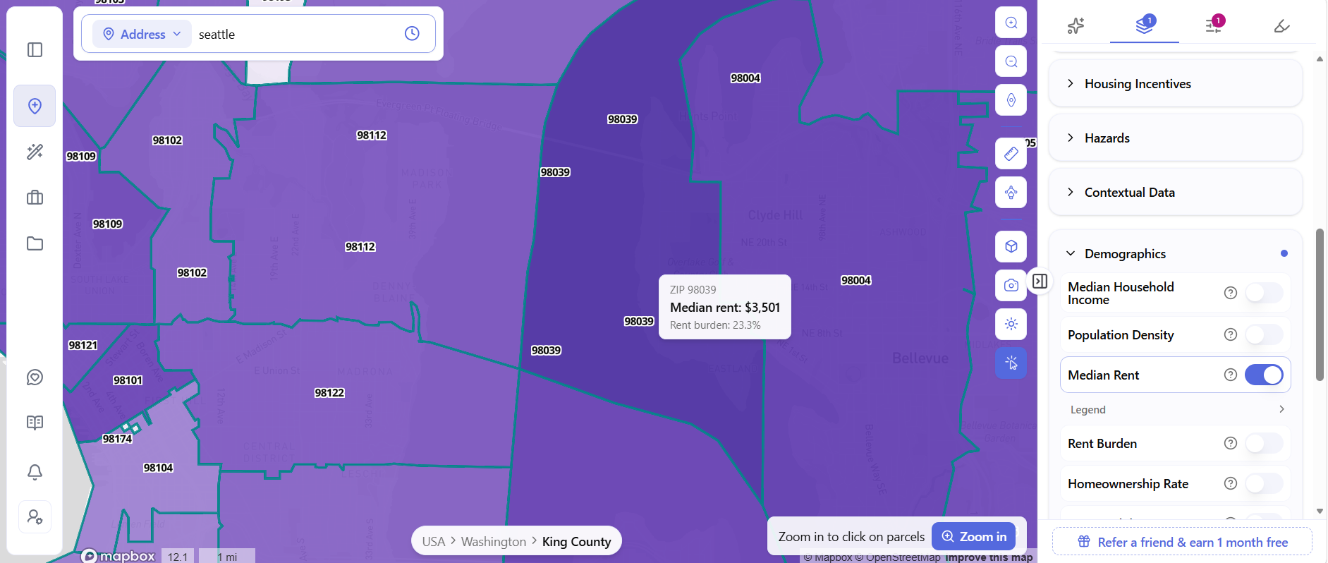
In ArchiWise, market-level data can be visualized directly on the map.
For example, the Median Rent layer shades ZIP codes according to rent levels. A developer can move across the market, compare areas, and inspect the underlying data before selecting a search area.
Other layers can answer different market-selection questions.
Housing incentive layers can identify areas associated with programs and designations such as Qualified Census Tracts (QCT), Difficult Development Areas (DDA), and Transit-Oriented Communities (TOC).
Transit-oriented development information can help identify locations where proximity to transit may support a particular development strategy.
Median household income and population density provide additional context for evaluating the market surrounding potential development sites.
Hazard information adds another important layer. Flood risk, wildfire exposure, and other environmental or physical constraints can affect site planning, development costs, insurance, and overall project feasibility.
This broader context is part of what Area Intelligence is designed to provide: insight into the environmental, infrastructure, demographic, and market forces surrounding a potential development location.
The important point is that this is not parcel-level due diligence yet.
It is market selection.
The goal is to answer:
Where should we search?
before asking:
Which property should we buy?
Step 2: Define Your Land Screening Criteria
Once the target market or search area has been identified, the next step is to define exactly what qualifies as a candidate site.
This is where a traditional parcel search starts to break down.
A developer may be looking for vacant land within a particular size range, specific zoning and permitted uses, redevelopment potential, a target property value, or particular ownership characteristics. The search may also depend on proximity to transit, demographics, incentives, infrastructure, or environmental conditions.
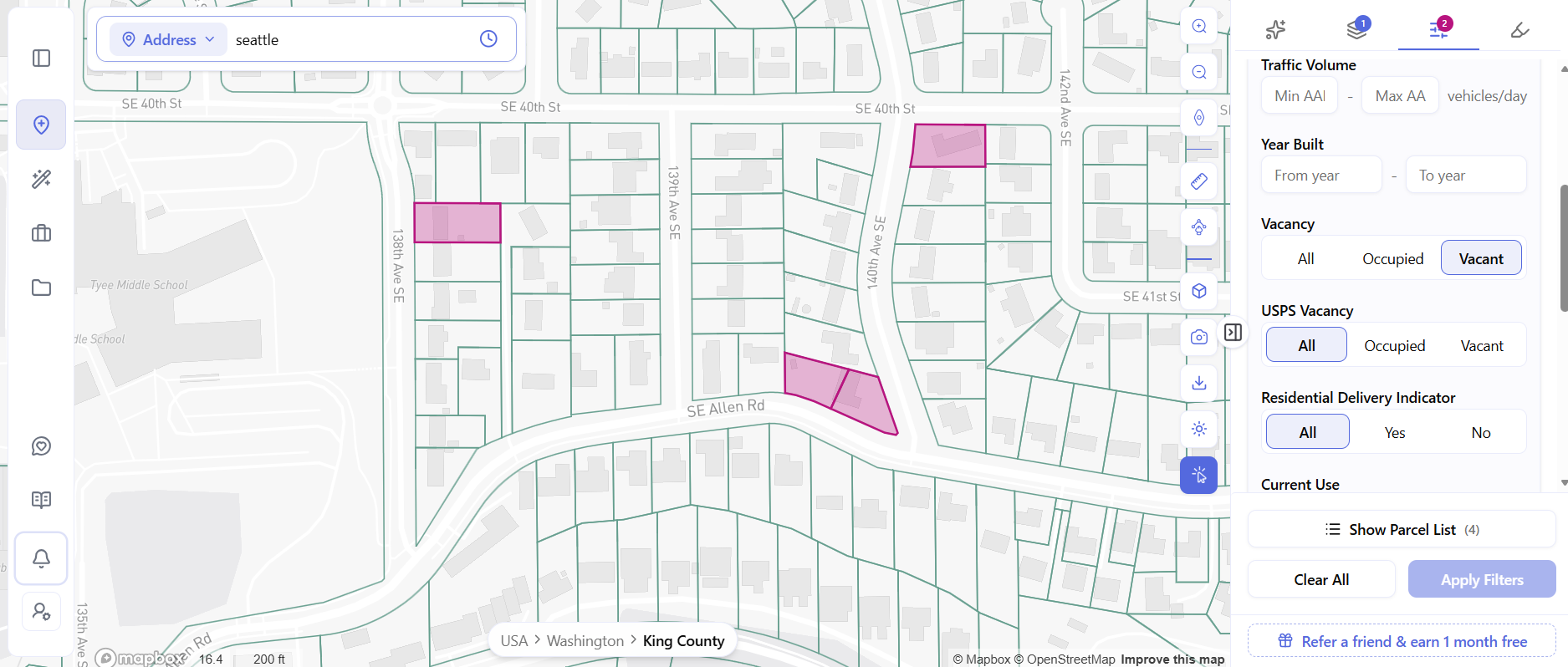
Instead of manually opening properties one by one, ArchiWise’s AI Site Selection workflow allows developers to define the characteristics that matter to their strategy and apply those criteria across a search area.
The map then narrows the market to parcels that fit the defined opportunity.
In the Bellevue example, filtering for vacant parcels within the selected search area produces four matching parcels.
That is the difference between browsing a market and screening a market.
The developer is no longer asking:
“Which of these properties looks interesting?”
The process is helping answer:
“Which properties match the criteria we’ve already defined?”
Step 3: Turn the Search Into a Development Site List
A map helps you see opportunities.
A parcel list helps you act on them.
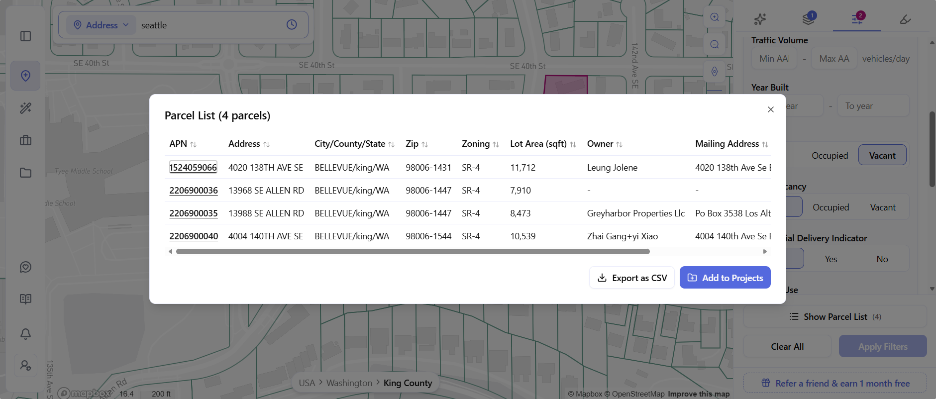
Once matching properties have been identified, ArchiWise’s Parcel List provides a structured view of the results.
The list can bring together information such as the APN, address, city, county, state, ZIP code, zoning, lot area, owner name, and mailing address.
Results can be sorted, exported as a CSV, or added to a project inside the platform.
This turns a visual site selection exercise into an actionable acquisition list.
The mailing address can also provide an additional ownership signal.
For example, if the mailing address differs from the property address, the property may be non-owner occupied.
That does not mean the owner will sell. But combined with other factors, it can help the acquisition team decide which properties deserve additional investigation.
Instead of having a map full of highlighted parcels, the development team now has a focused list of potential development sites.
Step 4: Evaluate Ownership and Off-Market Signals
Finding a promising site is only half the acquisition problem.
You also need to understand who owns it and how long they have held it.
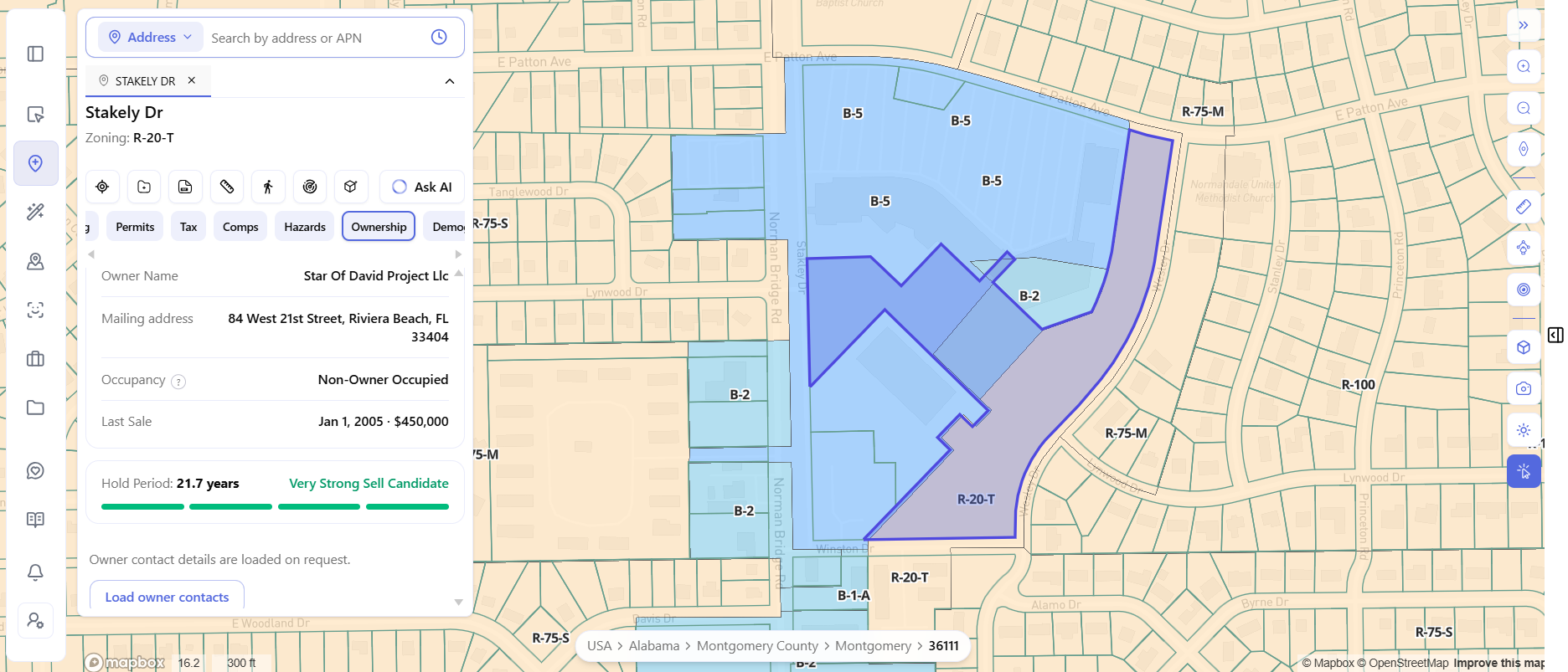
The Ownership view in ArchiWise brings several ownership-related signals together for each property, including ownership type, owner name, mailing address, occupancy status, last sale date, last sale price, hold period, Sell Candidate rating, and linked properties.
These signals can help developers prioritize which owners may be worth contacting.
For example, a long hold period combined with non-owner occupancy and an out-of-area mailing address can be useful as an off-market acquisition signal.
Consider the example of a parcel on Stakely Dr in Montgomery, Alabama.
The recorded owner is an LLC, the mailing address is in Florida, the property is marked non-owner occupied, and the recorded last sale was in 2005. Based on these ownership signals, the platform identifies the property as a Very Strong Sell Candidate.
That does not guarantee that the owner wants to sell.
It does something more useful:
It gives the acquisition team a reason to investigate.
The goal isn’t to predict that an owner will definitely sell. The goal is to help developers identify properties that may be worth pursuing before they become conventional listings.
Step 5: Find Adjacent Parcels and Assembly Opportunities
A promising parcel may not be large enough on its own.
Sometimes the opportunity is the property next door.
If a target site is too small for the intended development program, neighboring parcels may create an opportunity for land assembly. Adjacent properties can also reveal additional owners who may be relevant to an acquisition campaign.
ArchiWise’s Radius Map makes it possible to investigate the surrounding ownership landscape.
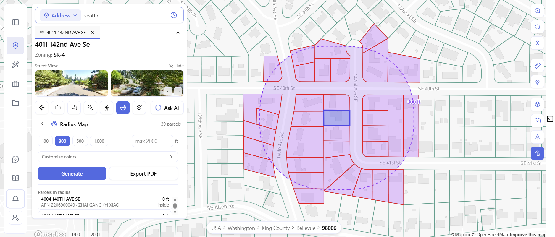
Users can select a radius of 100, 300, 500, or 1,000 feet. The platform then generates a list of parcels within the selected distance, including parcel and ownership information. The resulting data can also be exported as a PDF.
In the Bellevue example, a 300-foot radius around 4011 142nd Ave SE returns 39 surrounding parcels.
That gives the developer an immediate view of the ownership landscape surrounding the target site.
One neighboring parcel may already be on the acquisition team’s shortlist. Others may become assembly candidates.
And every additional owner represents another potential acquisition conversation.
This is another reason why site selection should not happen in isolation.
The best development opportunity may extend beyond the boundaries of the first parcel you find.
Finding the Site Is Only the Beginning
Identifying a promising development site is one of the most important steps in the acquisition process-but it is not the last question a developer needs to answer.
Once a site makes the shortlist, the question changes from “Can I find a property?” to “Can I actually develop it?”
That requires a deeper understanding of the opportunity.
A developer needs to understand the market surrounding the property, the zoning and development standards that apply to the site, the physical and financial conditions that could affect the project, and ultimately how realistic the path to approvals may be.
This is where the broader ArchiWise pre-development workflow comes into play.
AI Site Selection is the starting point. It helps developers move across a market, define their acquisition criteria, identify matching parcels, uncover potential off-market opportunities, and prioritize the sites worth investigating.
From there, Area Intelligence helps put the property into context by showing the environmental, infrastructure, demographic, and market forces surrounding the site.
AI Zoning Expert then helps developers investigate the rules governing the property, including permitted uses, setbacks, height, FAR, lot coverage, parking, overlays, and other parcel-specific zoning considerations.
Feasibility Analysis takes the evaluation further by helping developers test development scenarios and determine which strategy makes the most financial sense.
Finally, Entitlement Viability helps developers assess approval risk, timelines, and the potential path from a promising property to an approved development project.
The workflow therefore does not end when a parcel is found.
It progresses from:
Find the opportunity → Understand the area → Understand the site → Evaluate feasibility → Assess entitlement potential
That distinction is important.
The goal of site selection is not simply to produce a list of properties.
It is to identify the properties that deserve to move into deeper pre-development analysis.
And that is where AI Site Selection becomes the first step in a much larger workflow.
From Site Selection to an Acquisition Pipeline
Run this process across a target market and the output is more than a map full of parcels.
It becomes an acquisition pipeline.
The process starts with market selection and market-level intelligence, moves into site-selection criteria and matching parcels, and then progresses into ownership signals, hazard and incentive considerations, adjacent-property opportunities, and parcel-specific zoning research.
The result is a focused pipeline built around the questions that matter during early-stage acquisition:
Where is the opportunity?
Which parcels match the strategy?
Which sites have characteristics worth investigating?
Who owns them?
Are there environmental constraints or development incentives to consider?
Could neighboring parcels create a larger opportunity?
What does the zoning allow?
Is the site worth moving into deeper feasibility and entitlement analysis?
Instead of treating each question as a separate research project, developers can move through the early stages of acquisition with a clearer picture of which opportunities deserve deeper attention.
Why Smart Developers Start With the Market
The real advantage of this workflow is not simply that individual research becomes faster.
It is that the search itself becomes systematic.
A traditional acquisition process often starts with an available property.
A smarter real estate site selection process can start with an investment thesis.
For example, a developer may want to find vacant parcels within a certain size range, in areas with strong rental demand, appropriate zoning, access to transit, available incentives, manageable hazard exposure, and ownership characteristics that may support an off-market acquisition.
That is a much more powerful starting point than:
“Let’s see what is listed for sale.”
The first approach searches for an opportunity.
The second searches for inventory.
And those are not the same thing.
Many potentially valuable properties never appear in a conventional listing search. They may be owned by individuals, LLCs, or long-term owners who have never publicly marketed the property.
A market-wide site selection strategy allows developers to identify these properties based on what the site represents, rather than whether it is currently advertised for sale.
What Makes a Development Site Worth Pursuing?
There is rarely a single signal that makes a property attractive.
The strongest opportunities often emerge from the combination of several factors.
A site may have the right location, appropriate zoning, sufficient land area, strong surrounding demographics, favorable market conditions, development incentives, manageable environmental constraints, long-term ownership, non-owner occupancy, an out-of-area mailing address, or adjacent parcels with assembly potential.
Individually, each signal may tell you very little.
Together, they can create a much clearer picture of the opportunity.
That is why modern site selection is increasingly about connecting the signals, rather than simply collecting more data.
The objective is not to find the most properties.
It is to find the right opportunities.
The Bottom Line
Finding land for development doesn’t have to begin with a listing.
A modern acquisition strategy can start with the market itself: understand where the opportunity may exist, define the characteristics of the sites you want, and use AI Site Selection to identify parcels that match your strategy.
From there, the work continues.
The surrounding market needs to be understood. The site’s zoning and development rules need to be investigated. The project’s feasibility needs to be evaluated. And the potential path through entitlements needs to be considered.
That’s the broader idea behind ArchiWise.
AI Site Selection helps developers find the opportunities. Area Intelligence helps them understand the market around those opportunities. AI Zoning Expert helps them investigate what the site may allow. Feasibility Analysis helps evaluate whether the development opportunity makes sense. And Entitlement Viability helps assess whether the project has a realistic path forward.
The result is a workflow that moves beyond simply finding land.
It helps developers move from:
“Where should we look?”
to
“Which sites are worth pursuing?”
and ultimately to:
“Can this become a viable project?”
For developers looking to find land for development, the advantage is not simply finding more parcels.
It is finding the right opportunities and having the intelligence to understand what they could become.
The market already contains potential development sites.
The question is whether your acquisition and pre-development process is designed to find them – and determine which ones are actually worth pursuing.
Ready to Find Your Next Development Site?
Stop waiting for the next listing to appear.
Start with your investment strategy, define the characteristics of the site you want, and use AI-powered site selection to identify the properties worth investigating.
Find the market. Screen the sites. Understand the opportunity. Move toward the project.