


Picture two 10,000 square foot lots on the same street, both zoned for apartments. Same size, same zone, same asking price. One can hold 9 homes. The other can hold 12.
Nothing about the dirt is different. One lot sits within half a mile of a busy transit stop, and that changes which rule caps the building. Price both lots off the zoning map alone and you will overpay for one of them.
A yield study in real estate is how you catch that before you make an offer.
What is a yield study in real estate?
A yield study is an early estimate of how much you can actually build on a specific site: how many units, how many buildable square feet, and roughly what shape the building will take. It starts with the zoning code, then subtracts everything that eats into the site, including setbacks, parking, open space, easements and physical constraints.
The answer is one number, usually a unit count or buildable square footage. Everything that follows depends on it: what you can pay for the land, how the pro forma works, and whether the deal is worth pursuing at all.
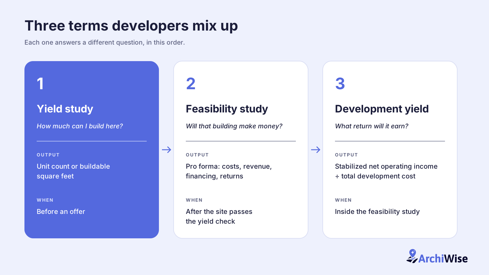
A yield study answers “how much can I build here?” It does not answer “will it make money?” That is the job of the feasibility study that comes next.
Why the zoning maximum is not your yield
Zoning gives you a ceiling in theory. The site gives you the ceiling in practice.
Most codes limit development in several ways at once, and each rule creates its own maximum:
- Density: how many units the lot area allows
- Building envelope: what fits inside the setbacks, height limit and floor area ratio
- Parking: how many spaces the code requires per unit, and whether they physically fit
- Open space: how much usable outdoor area each unit needs
- Site conditions: easements, flood zones, slopes, fault lines and other hazards
Your real yield is the lowest of those ceilings. That lowest rule is the binding constraint. Find it and you know what the site can really hold.
This is also why a lot zoned for apartments can still disappoint. We covered that trap in detail in the gap between permitted and buildable.
How to do a yield study, step by step
Let’s walk through one lot: a hypothetical 100 foot by 100 foot parcel, 10,000 square feet, in the R3 Multiple Dwelling zone in Los Angeles. The zoning, yard and parking rules below come from the Los Angeles Municipal Code. The ground-floor space count, floor plate and open space figures are simplified assumptions for teaching purposes.
Step 1: Confirm the zone and every layer on top of it
Start with the base zone, then look for anything layered over it: height districts, specific plans, overlay zones and conditions attached to the zoning. A single overlay can change the answer, so this step comes before any math.
Step 2: Run the density math
The R3 zone allows one dwelling unit for every 800 square feet of lot area, under Section 12.10 of the Los Angeles Municipal Code. Divide 10,000 by 800 and you get 12.5, so the density ceiling is about 12 units before rounding rules or bonuses.
Density formulas have their own traps, from rounding to which lot area counts. For the full walkthrough, see our step-by-step density math for multifamily lots.
Step 3: Draw the building envelope
The same code section requires a 15 foot front yard, a 15 foot rear yard, and side yards of 5 feet plus 1 foot for each story above the second, capped at 16 feet. For a four-story building, that means 7 foot side yards.
Take those away and the buildable footprint shrinks from 10,000 square feet to 86 feet by 70 feet, or 6,020 square feet. Nearly 40 percent of the lot is gone before a single wall goes up.
Stack that footprint over the floors the height limit allows and you have the envelope ceiling. Assume a four-story building with parking on the ground floor and three residential floors above, at about 1,000 gross square feet per unit including hallways and stairs. That gives you roughly 18 units. On this lot, the envelope is not what holds you back.
Step 4: Fit the parking
Parking is where many yield studies fall apart. Required spaces need real room for drive aisles and ramps, and on a small lot they compete directly with homes.
Section 12.21 A.4 of the Los Angeles Municipal Code requires 1.5 parking spaces for each dwelling unit of three habitable rooms — one space for smaller units, two for larger ones. Take the 1.5 figure and assume the ground floor fits 14 spaces. That caps the project at 9 units. Parking, not zoning density, is the binding constraint.
Step 5: Check open space and site conditions
Next, subtract required open space, recorded easements and anything the ground itself rules out. Flood zones, fault proximity, methane zones and steep slopes can all remove buildable area or add cost. Our hazard risk assessment guide for development sites walks through each one.
In our example, open space allows about 14 units and there are no easements, so parking still binds.
Step 6: Take the lowest number
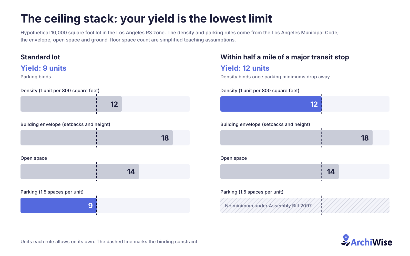
Line the ceilings up: 12 from density, about 18 from the envelope, about 14 from open space and 9 from parking. The yield is 9 units.
That is the number you price the land against.
The same lot, near a transit stop
Now move the lot. Under Assembly Bill 2097, California cities generally cannot impose minimum parking requirements on development within one half mile of a major transit stop, according to the California Department of Housing and Community Development. A major transit stop includes an existing rail or bus rapid transit station, a ferry terminal served by bus or rail, or the intersection of two or more major bus routes running every 20 minutes or less during peak commute periods.
Cities can still impose minimums in limited cases by making written findings within 30 days of a completed application. But that exception does not apply at all to a housing development with fewer than 20 units — so on a lot this size, the city cannot claw the parking requirement back.
With the parking ceiling gone, the next lowest limit is density. The yield moves from 9 units to 12. Same lot, same zone, three more homes, and a yield one third larger. The land is suddenly worth a lot more to you than to a buyer who stopped at the zoning map.
State transit laws keep changing what these lots can hold. For the newest shift in California, see what developers can now build near transit under Senate Bill 79.
When to run a yield study
Run it before you make an offer, not after you are under contract.
A detailed yield study usually comes from a civil engineer, land planner or architect, which takes time and fees. So teams tend to save it for sites they already like. That order is backwards. The sites you rule out early are the ones that save you the most money.
The pattern that works is a quick first pass on every site, followed by a detailed study on the survivors. For a look at running that first pass across a whole shortlist, read how to screen fifty sites in a single afternoon.
How ArchiWise speeds up the first pass
Most of a yield study’s time goes into gathering inputs, not doing the math. ArchiWise pulls those inputs into one place for any parcel in the United States:
- The Zoning tab shows the designation, permitted uses and development standards, with a link to the governing code.
- ArchiWise AI answers questions like “how many units can I build on this lot?” in plain language and cites the code section behind each figure.
- The Hazards tab returns flood, fire, seismic and methane readings together, so site constraints show up early.
- Feasibility Analysis takes a shortlisted site through massing, program and pro forma in a six-step workflow.
Here is Step 2 on a real parcel: a 16,034 square foot R3 lot in Los Angeles, where the same 800-square-feet-per-unit rule gives a density ceiling of 20 units. That is one ceiling, not the yield. Parking, envelope and open space still have to be checked against it.
ArchiWise does not replace a licensed engineer’s final site plan. It helps you decide which sites deserve one.
The takeaway
Before your next offer, write down every ceiling, not just density. Density, envelope, parking, open space and site conditions each set a limit. The smallest one is your yield, and it is the only number worth pricing land against.
Find out what your next site can really hold.
See what the code allows on your next parcel in ArchiWise.
Frequently asked questions
Is a yield study the same as development yield?
No. Development yield, also called yield on cost, is a return metric: stabilized net operating income divided by total development cost. A yield study measures how much you can build. You need the yield study first, because its unit count feeds the development yield calculation.
What is the difference between a yield study and a feasibility study?
A yield study tells you what fits on the site. A feasibility study tests whether that building makes financial sense, using construction costs, rents or sale prices, and financing terms. The yield study comes first because the feasibility study needs its unit count.
Who prepares a yield study?
Quick early yield studies are often done in house by acquisition teams. Detailed ones usually come from a civil engineer, land planner or architect, who produces a preliminary site plan or test fit.
How accurate is a quick yield study?
It is only as accurate as its inputs. Missing an overlay, an easement or a parking rule can move the number a lot, as the transit example shows. Treat a quick study as a screening tool and confirm the final yield with licensed professionals and the local planning department.
Does a yield study work for single-family subdivisions?
Yes. For subdivisions, the study counts lots instead of units, and roads, stormwater detention and required open space usually take the biggest share of the land.
What do I need to start a yield study?
The parcel’s zoning designation and any overlays, the lot dimensions or a survey, the current zoning code, and any known easements or hazard maps. A title report and a boundary survey sharpen the answer later.