

Land acquisition software has changed fast.
Five years ago, finding a development site meant county websites, satellite imagery and a spreadsheet. Now real estate site selection software will screen an entire market against your criteria, read the zoning code for you, and estimate what a parcel could support – before you call anyone.
But they don’t all do the same job.
Some are built for homebuilders running national pipelines. Some for small developers testing one infill site. Some aren’t analysis platforms at all – they’re data feeds you build on top of.
This guide compares six: what each does, and who each fits.
Quick answer
- Enterprise homebuilders and national land teams → Prophetic
- Market screening and site selection → ArchiWise
- Sourcing plus owner outreach and deal pipeline → Pillar
- Zoning capacity in digitized markets → Deepblocks
- Feasibility, massing and pro forma → Algoma
- Raw parcel data, APIs and GIS → Regrid
At a glance
| Platform | Core strength | Best for |
| Prophetic | AI land acquisition suite, sourcing through pipeline | Enterprise homebuilders |
| ArchiWise | Criteria-based market screening and zoning interpretation | Site selection |
| Pillar | Parcel search, skip tracing, direct mail, CRM | Sourcing plus outreach |
| Deepblocks | Parcel-level development capacity | Capacity in covered cities |
| Algoma | Instant feasibility, massing, renderings, pro forma | Small and mid-sized developers |
| Regrid | Nationwide parcel data infrastructure | APIs and custom workflows |
First, Decide What Job Your Land Acquisition Software Has to Do
The most common mistake in choosing land development software is treating these platforms as interchangeable.
They fall into four groups, and the right one depends on where your process stalls.
Sourcing platforms answer which parcels should I be looking at?
You bring criteria. They return matches.
Feasibility platforms answer what can I build here, and does it pencil?
You bring a parcel. They return a program.
Deal platforms answer how do I get from a shortlist to a signed contract?
Outreach, skip tracing, pipeline.
Parcel data platforms answer can I get parcel data into my own stack?
No workflow included.
Several platforms below span two or three of these. None spans all four equally well.
The 6 Best Land Acquisition Software Platforms for Developers
1. Prophetic
Prophetic calls itself the AI-native platform built for land acquisition, and it’s the most enterprise-oriented option here.
The suite covers the full arc:
- SearchAI – searches entire markets using 50+ parameters, with custom drawn boundaries
- ZoneAI – reads and interprets municipal codes across jurisdictions nationwide
- SiteAI – feasibility in seconds, mapping constraints with sources and generating preliminary layouts
- DevMap – tracks subdivisions and entitled projects, surfacing them during entitlement rather than after announcement
- LRM – the Land Relationship Manager, handling pipeline and alerts
The customer list is the strongest signal in this comparison. D.R. Horton, the largest US homebuilder, deployed Prophetic org-wide across 30+ states in November 2025. M/I Homes followed in 2026. Century Communities, Holt Homes, City Ventures and Pahlisch Homes also appear on their site.
Prophetic reports a 95.3% daily use rate over 12 months across enterprise customers, and is SOC2 certified with mobile apps, API access and SSO.
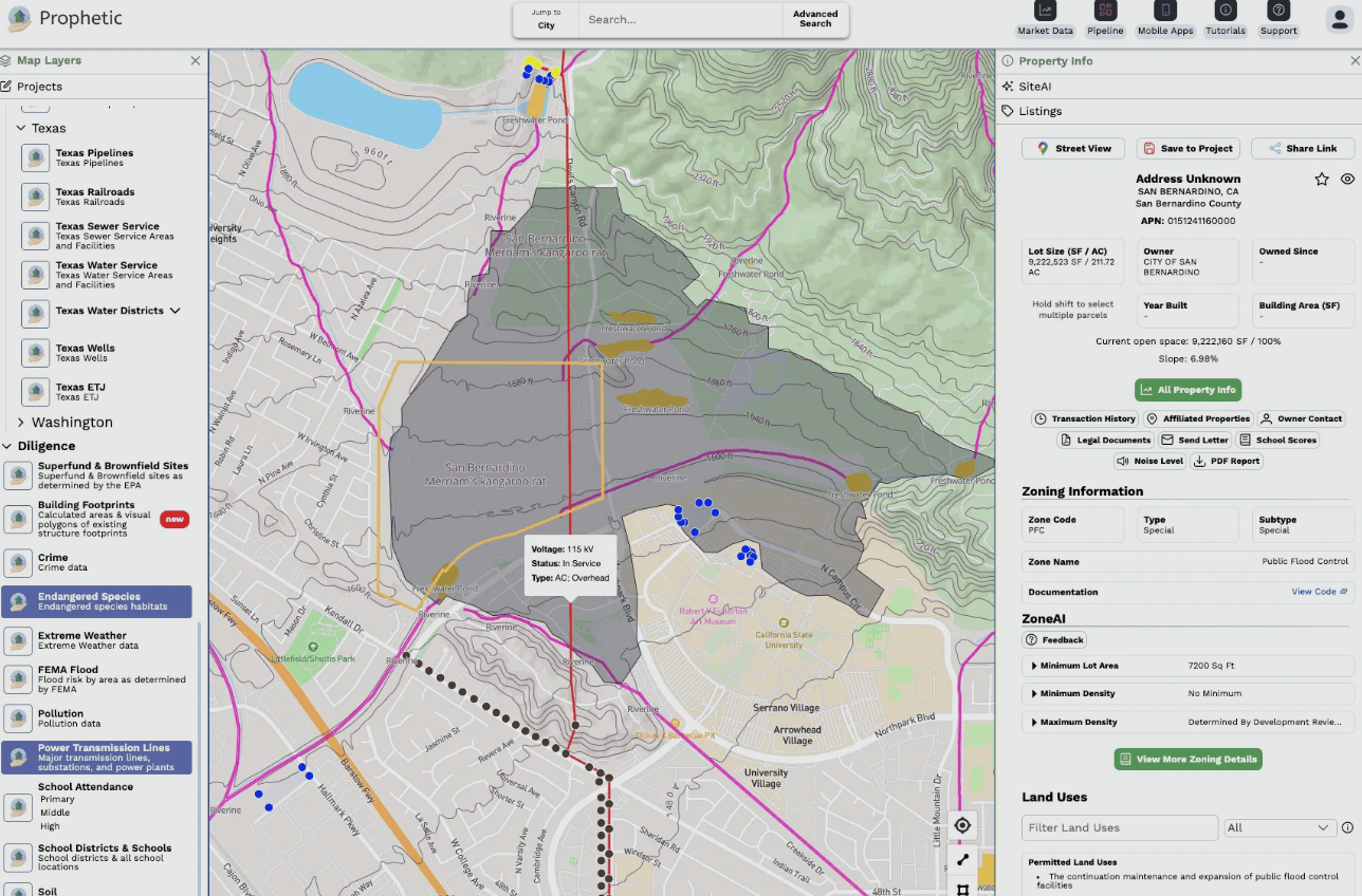
Best for: homebuilders and land teams running high deal volume who want sourcing, feasibility and pipeline in one system.
2. ArchiWise
ArchiWise is a pre-development site analysis platform built around one job: real estate site selection. Not testing a parcel someone sent you – finding the parcels worth testing.
You can search two ways.
Type what you want in plain language – show me vacant commercial parcels over an acre in this area – and refine in the same thread. Or build it in the filter panel.
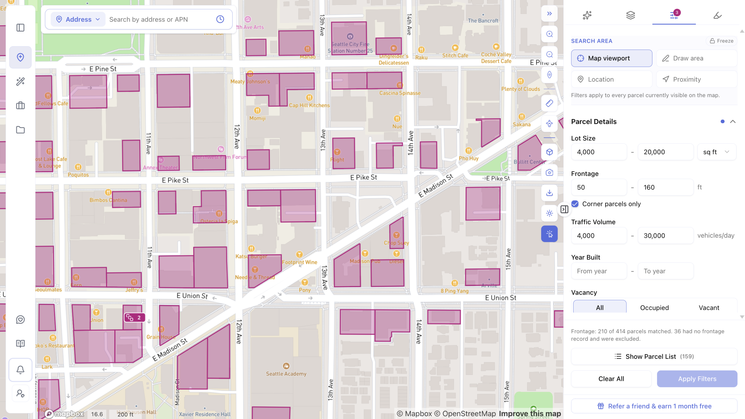
Beyond the basics – lot size, year built, current use, value, zoning – the filters go further:
Ownership. Screen an entire market by ownership type: private persons, trusts, businesses, nonprofits, government. Find who holds what without opening parcels one at a time.
Hazards. Flood exposure and mapped wetlands are filter conditions, run against live FEMA and National Wetlands Inventory data. Constrained sites drop out of the search instead of surfacing three months into diligence.
Proximity. Screen by distance to a school, transit stop, point of interest or any address.
Apply criteria to a drawn polygon, the map view, a ZIP code or a city. Results switch to a list view, export as CSV, or go straight into a project.
Then it reads the code. Each matching parcel opens a full record – zoning, ownership, tax, comps, hazards, incentives – and the AI interprets the jurisdiction’s own planning documents for that parcel: what’s permitted by right, what the dimensional standards are, where an overlay changes the answer. Every figure cites the code section it came from, so you can check it.
Map layers add surrounding context – hazards, infrastructure, housing incentives, transit and demographics across a whole market.
AI Zoning Expert handles interpretation. AI Site Selection handles the search.
Best for: developers, investors and acquisition teams screening markets to find sites, particularly where ownership signals matter to off-market sourcing.
3. Pillar
Pillar positions itself as an all-in-one land acquisition platform replacing the patchwork of GIS tools, spreadsheets and public records databases land teams currently use.
It spans sourcing and outreach in one place: search 160M+ parcels, analyze zoning and demographics, find owner contact information, send direct mail, and manage a deal pipeline. Search works conversationally – describe what you want in plain English and matches drop onto the map.
Pricing is public. Free includes nationwide parcel and owner data, 5 AI messages a day, 3 skip traces and 3 zoning reports. Pro is $199 per user per month billed annually, adding skip tracing, owner outreach and the full CRM. Enterprise is custom.
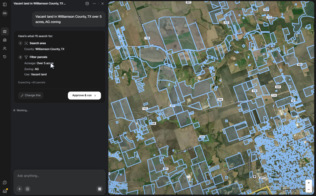
Best for: land teams that want sourcing and owner outreach in the same tool, particularly for off-market campaigns at volume.
4. Deepblocks
Deepblocks is Miami-based zoning analysis software focused on development capacity – a GIS-like system that digitizes zoning rules down to the parcel level.
Its Market Scanner identifies properties matching combinations of development and market criteria. Its zoning tools digitize both the values and the underlying logic, so rules can be applied across many properties at once rather than read parcel by parcel.
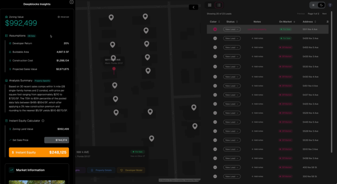
Best for: developers who already know their target markets and want deep capacity analysis within them.
5. Algoma
Algoma is a New York company founded in 2023 by three Harvard graduates, which raised $2.3M in seed funding in May 2025. Its pitch: enter any US address and get a complete feasibility overview in under 60 seconds.
The platform covers AI zoning analysis, site capacity studies, auto-generated site plans, market comps and demographics, photorealistic AI renderings, and PDF and CAD export – so a site can go from address to investor-ready package without commissioning consultants.
Site search is also available: development-ready parcels across all 50 states, with 20+ GIS filters including zoning, acreage, flood zone and opportunity zones, or a drawn boundary. It sits on the Pro and Enterprise tiers.
Pricing is public: Free $0, Standard $99 per seat per month, Pro $199 per seat per month.
Worth knowing: Algoma’s own help pages name its data sources – parcel data from Regrid, zoning from Zoneomics, rent comps from HelloData.
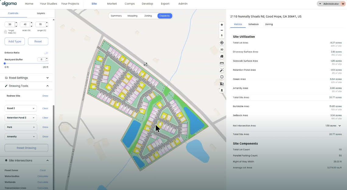
Best for: small and mid-sized developers who need feasibility, massing and a pro forma fast.
6. Regrid
Regrid is a parcel data platform rather than an analysis application – the foundation several other tools are built on.
It reports 100% US parcel coverage across all 50 states and US territories, with standardized boundaries, ownership records, addresses, building footprints and land-use codes. Access comes through web tools, REST API, bulk data and GIS-compatible services. Pro accounts add a filter tool that highlights matching parcels, tallies them and shows them in list view, plus export to shapefile, spreadsheet or KML.
Its Standardized Zoning product covers a substantial share of US counties.
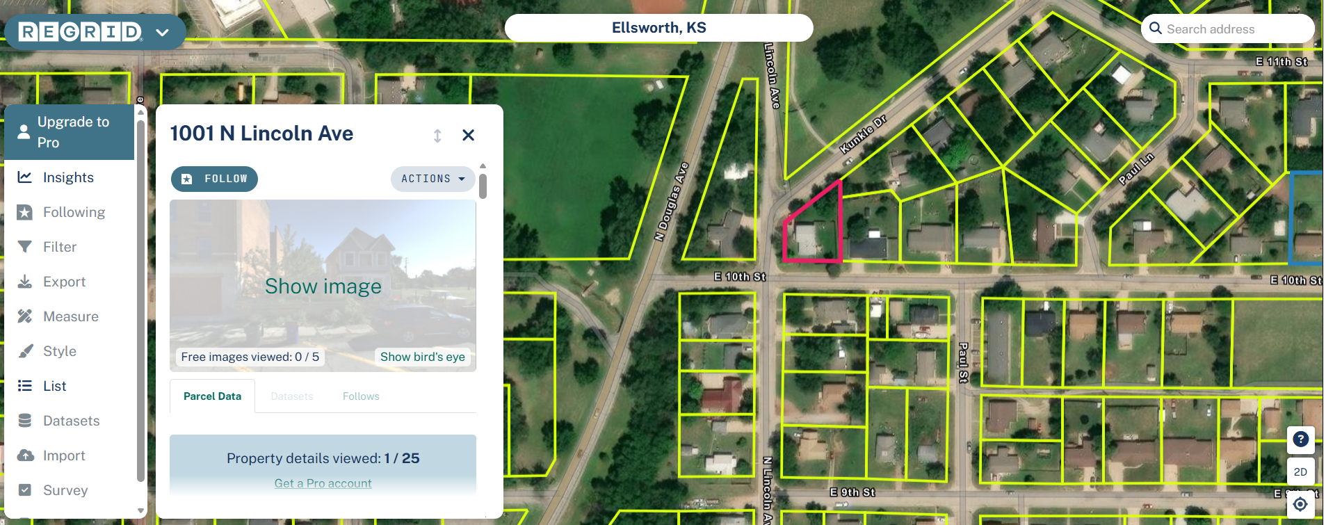
Best for: teams building their own tools, GIS professionals, and anyone who wants the data without the workflow.
What to Check Before You Buy Land Development Software
Coverage is never one number
Don’t accept “nationwide” without asking what’s nationwide.
Parcel coverage, zoning coverage and zoning interpretation are three different things. Regrid has full US parcel coverage and a narrower zoning footprint. Algoma offers nationwide parcel data with full analysis in 160+ cities. ArchiWise’s parcel data and map layers are nationwide, while its AI zoning interpretation expands jurisdiction by jurisdiction.
Every vendor in this space has a coverage gradient. The ones worth trusting publish it.
Whose data is it, really?
Several platforms in this category license their underlying data rather than building it. Algoma publishes this openly – Regrid for parcels, Zoneomics for zoning.
That’s not a weakness. But it’s worth asking, because it tells you what refresh cycle you’re actually on and whether two tools you’re comparing run on the same source.
Source transparency in zoning analysis
Zoning depends on base district, overlays, special districts, lot geometry, existing structures, density rules, setbacks, height limits, parking, conditional use provisions – and state law sitting above local code.
A platform that returns a number without showing where it came from is asking for trust you can’t verify. The most useful answers name the code section and flag where an overlay might change the result.
Where the workflow ends
Most buyers skip this one.
Some platforms stop at a shortlist. Some continue into massing and pro forma. Some carry the deal through outreach and close. Map the tool against your actual process and find where the handoff happens.
Fit for your deal volume
A platform built for a national homebuilder evaluating hundreds of sites a year is overbuilt for a developer doing three. The reverse is also true, and more expensive.
Frequently Asked Questions
What is land acquisition software?
Platforms that help developers find, evaluate and manage potential development sites – typically combining parcel data, zoning analysis and ownership records, and in some cases feasibility modeling, owner outreach and pipeline management.
What is the best land acquisition software?
It depends on deal volume and workflow. Prophetic for enterprise homebuilders, ArchiWise for market screening and site selection, Pillar for sourcing plus outreach, Deepblocks for zoning capacity, Algoma for fast feasibility, Regrid for raw data.
Is land acquisition the same as site selection?
No. Site selection is choosing which parcel to pursue. Land acquisition is the full process from screening through to close. Some platforms cover only the front end.
What software do land developers use to find sites?
Most use some combination of land acquisition software for sourcing, zoning analysis software for what a parcel allows, and a parcel data platform for underlying records. Larger teams increasingly consolidate these into one suite.
Is there software for finding off-market land?
Yes. Platforms that screen by criteria across all parcels – rather than filtering listings – surface off-market land by default, since most parcels aren’t for sale at any given time.
Is there free land acquisition software?
Several platforms here offer free tiers. Pillar’s free plan includes nationwide parcel and owner data with limited AI messages and skip traces. Algoma’s includes parcel data and GIS layers. Public GIS portals and county assessor sites are also free, but fragmented.
Do I need more than one platform?
Many teams use two – a sourcing platform to find candidates, and a specialist for deeper zoning or feasibility work.
The Bottom Line
There’s no single best platform here – because these six aren’t solving the same problem.
Running a national land pipeline? The question is whether one system carries sourcing through to close.
Screening markets for sites nobody has listed? It’s about criteria depth and ownership data.
Already have a parcel and need to know if it pencils? It’s about feasibility speed.
Building your own tools? It’s about data access.
The useful question isn’t which platform is best. It’s which one matches the stage of the process where you actually lose time.
Coverage is the first question, not the last. Check it before you subscribe.