

Five things that make Los Angeles the hardest zoning market in America – and what AI does about each one.
In most cities, a block has one set of rules. In Los Angeles, it can have a dozen.
Take the blocks around Windsor Square and the Park Mile, for example. Zoom into the zoning layer and count what’s there:
RE15-1-HPOZ. R1V3-RG. CR(PKM)-1. [Q]R3-1-HPOZ. OS-1XL-HPOZ. RD3-1.
More than a dozen different rulebooks in one frame, most of them touching each other across a property line.
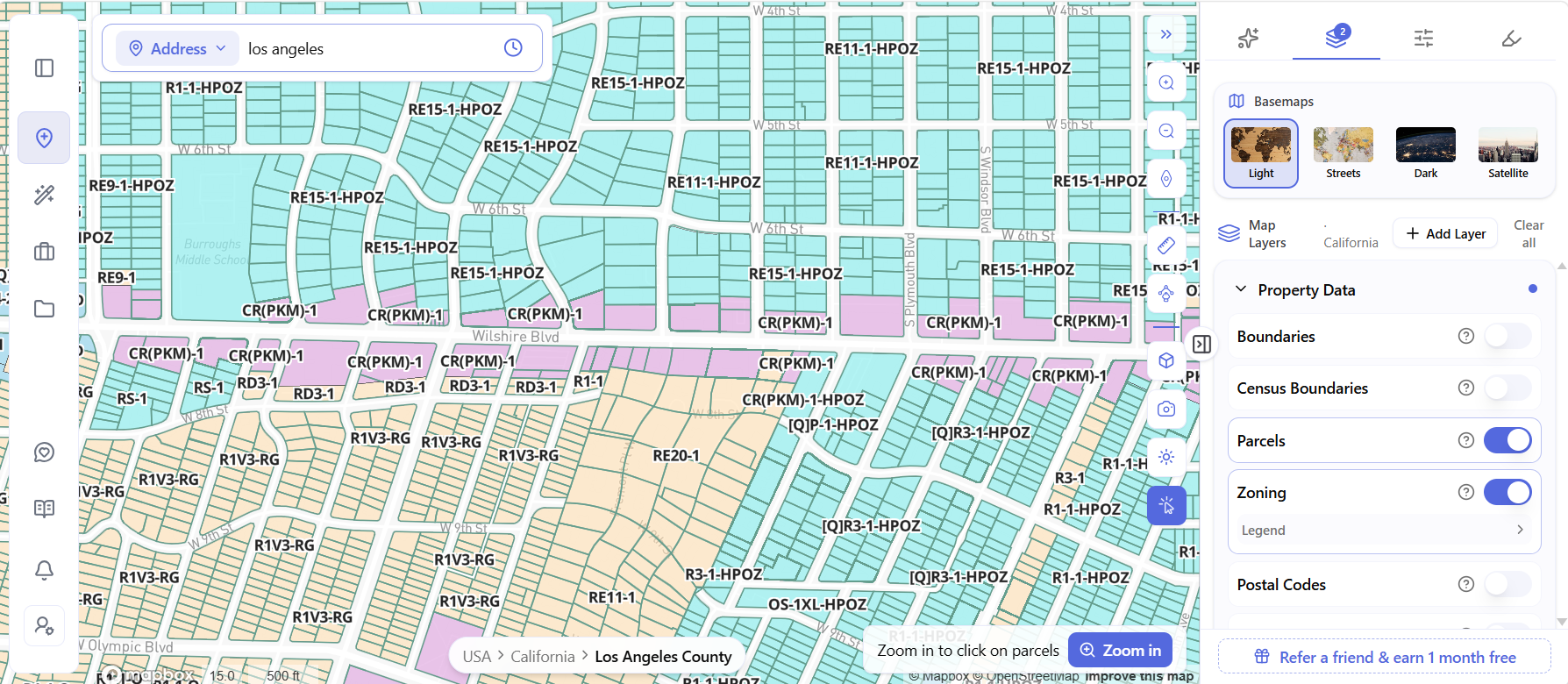
This isn’t an unusual block. This is Los Angeles.
LA is hard not because its rules are stricter than New York’s. It’s hard because there are more rules, they overlap, the city is running two zoning codes at once, and the incentive layer on top has been rewritten four times since early 2025.
Here’s what costs developers money, and what AI does about it.
1. One Parcel, Five Rulebooks
A zoning designation in LA is a stack, not a label.
Base zone. Height district. [Q] conditions. Overlay zones. Specific Plan. The most restrictive layer wins – and it’s usually the one hiding outside the zoning string.
Two real examples from that same map:
R1V3-RG isn’t a typo. It’s one of sixteen R1 Variation Zones LA created in 2017. “R1V” sets a variable-mass building envelope. The “3” caps residential FAR between 0.35 and 0.45 depending on lot size. “RG” requires covered parking to be detached and at the rear of the lot. Three separate controls, one string, none of them in the standard R1 code section.
CR(PKM)-1 is commercial land inside the Park Mile Specific Plan – Wilshire between Highland and Wilton. From the ordinance:
- Buildings limited to three stories and 45 feet. Six stories is allowed only in four specifically listed areas.
- FAR capped at 3:1, lot coverage at 50%.
- Stores, restaurants, hotels and schools expressly prohibited, no matter what the commercial base zone permits.
- Everything except single-family housing needs Design Review Board approval before a permit issues.
A developer reading “commercial zone on Wilshire Boulevard” and pricing a site accordingly would be wrong on height, use, coverage and process – all at once.
The old way: decode the string, find the LAMC section, dig the [Q] ordinance out of a Council file, figure out if a Specific Plan applies, download the PDF, read it. Hours per parcel. The Specific Plan step is the one people skip.
With AI: click the parcel and the whole stack appears at once – zone, height limit, overlay, [Q] condition, FAR, setbacks. Permitted uses show as three lists: as of right, conditional, and prohibited.
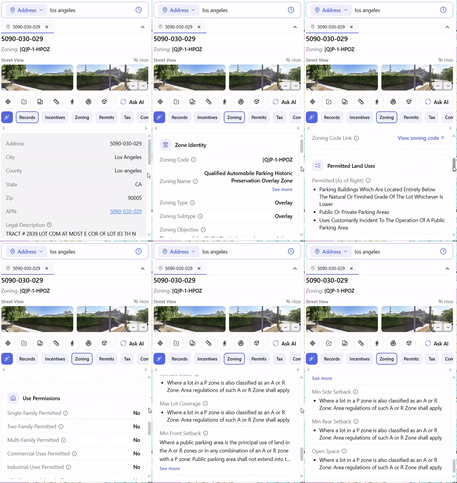
Look at the as-of-right list for this parcel. Parking areas. Parking buildings below grade. Uses incident to operating a public parking area.
That’s it. On a leafy lot in the middle of Windsor Square.
But a list of uses still isn’t a decision. Most tools stop here – they show you the designation and leave the interpreting to you.
So ask it plainly instead.
![ArchiWise AI answering whether apartments can be built on a Los Angeles parcel zoned [Q]P-1-HPOZ, with cited code sections](https://blog.archiwise.ai/wp-content/uploads/2026/09/Chat_Answer_Zoning.gif)
No. Apartments aren’t a permitted use, and the P-1 base zoning is fundamentally inconsistent with residential. The [Q] condition and HPOZ review sit on top of that.
Then it shows its work – the ordinance amending LAMC Section 12.20.3, the HPOZ guidance, the page numbers. And it flags what it can’t see: the neighborhood’s specific Preservation Plan, which still has to be pulled directly.
That’s the shift. Not more data. An answer, with the sources attached, so you can check the reasoning instead of trusting it.
More on reading the strings themselves in our LA zoning guide.
2. LA Runs Two Zoning Codes at the Same Time
Los Angeles adopted a brand-new zoning code – Chapter 1A of the LAMC – in October 2024. It took effect in the Downtown Community Plan Area in early 2025, replacing height districts with Form, Frontage and Density Districts.
Everywhere else, the 1946 code still governs.
Boyle Heights, Harbor Gateway and Wilmington have new zoning under Council review. Roughly a dozen more community plan areas are in development. The new code arrives one community plan at a time, across all 34 of them.
So for the next several years, what a zoning code means in LA depends on which side of a community plan boundary you’re standing on.
This is exactly where general AI breaks. Ask ChatGPT what a Downtown zoning string permits and it reasons from whichever code it saw more of in training. It can’t know which chapter applies, because that depends on a boundary it’s never seen.
Document-grounded AI is different. It retrieves from the documents that govern that location – the right chapter, the right community plan, the right overlay – and cites the section each answer came from. We broke that difference down in Zoning with AI.
3. The Incentive Rules Keep Changing
Four times in eighteen months. This is the one costing developers the most.
February 2025 – CHIP. LA’s big new incentive program took effect. It rebuilt the city’s density bonus and folded the old TOC incentives into a new program with a new name.
October 2025 – SB 79 signed. The state law allowing up to nine stories near heavy rail. Effective July 1, 2026.
December 2025 – ED1 became law. The mayor’s fast-track for 100% affordable projects moved from a temporary directive into the Municipal Code. It can’t be revised by memo anymore.
June 2026 – LA said no. The city adopted two ordinances that pause SB 79 until roughly 2030. Instead, a new Low-Rise Ordinance allows two to four stories in 57 Opportunity Station Areas – including streets zoned single-family. HPOZs were mostly left out.
So here’s the trap. A developer reads a national SB 79 explainer, sees nine stories near transit, and prices a site accordingly. In Los Angeles, that’s the wrong document.
And the map makes it worse, because the SB 79 transit zones do exist over LA – half-mile rings around every qualifying stop, covering Downtown and the corridors running out of it.
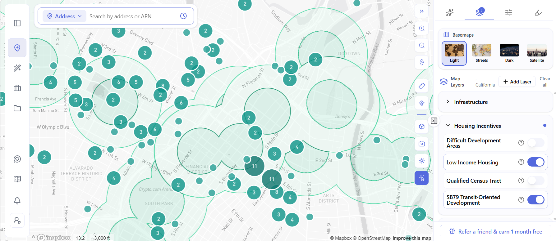
The zones are real. The benefits are paused.
What a parcel inside one of those rings can actually do today depends on LA’s local ordinances, not the state standards the map suggests. Turn on the Low Income Housing layer too and you can see where affordable projects have already been financed in the same corridors.
The real question isn’t “does SB 79 apply.” It’s narrower: is this parcel in one of the 57 Opportunity Station Areas, and what can I build there?
With AI: ask the parcel. TOC tier, QCT, DDA, SB 9, SB 35, SB 79 and AB 2011 all screen automatically. Then ArchiWise AI answers the part that’s actually hard – which programs stack, and what you end up with when they do.
One caution. LA passed two major ordinances in June 2026 alone. Any system ingests new documents continuously, but for numbers going into a pro forma, check the ordinance date.
4. The Rules That Kill Deals Aren’t in the Zoning Code
Some of LA’s most expensive constraints never show up in the zoning string.
Methane. After a 1985 methane fire in the Fairfax district and large gas pockets found at Playa Vista in 1999, LA adopted citywide mitigation rules under Division 71, LAMC Section 91.7101. Parcels sit in a Methane Zone or a Methane Buffer Zone. Site testing sets a mitigation level from I to V, and LADBS can withhold building permits until adequate protection is designed. Full story: Methane: The Site Hazard Hiding in Plain Sight.
Historic districts. LA has 35 HPOZs, each with its own preservation plan and review board. HPOZ status now decides both design review and whether a parcel gets the new Low-Rise incentives.
Fire and seismic. Very High Fire Hazard Severity Zones, fault zones and liquefaction areas change what’s buildable and what it costs.
With AI: these appear as map layers across a whole corridor before you click anything, and as parcel-level risk cards – Clear, Moderate or High – once you do.
5. The Hard Part Isn’t One Parcel. It’s Two Hundred.
Everything above assumes you already have an address. Most site selection starts that way – with whatever a broker happened to send you.
That’s backwards. The parcels that fit your buy box exist whether or not anyone listed them.
With AI: draw a polygon over a corridor and filter every parcel inside it – by lot size, year built, vacancy, current use, value, ownership.
And by zoning, three ways: by zoning code, including the compound ones, so you can pull every R2-1-HPOZ or (T)(Q)CR-1VL parcel in a corridor. By land use. Or by zoning type.
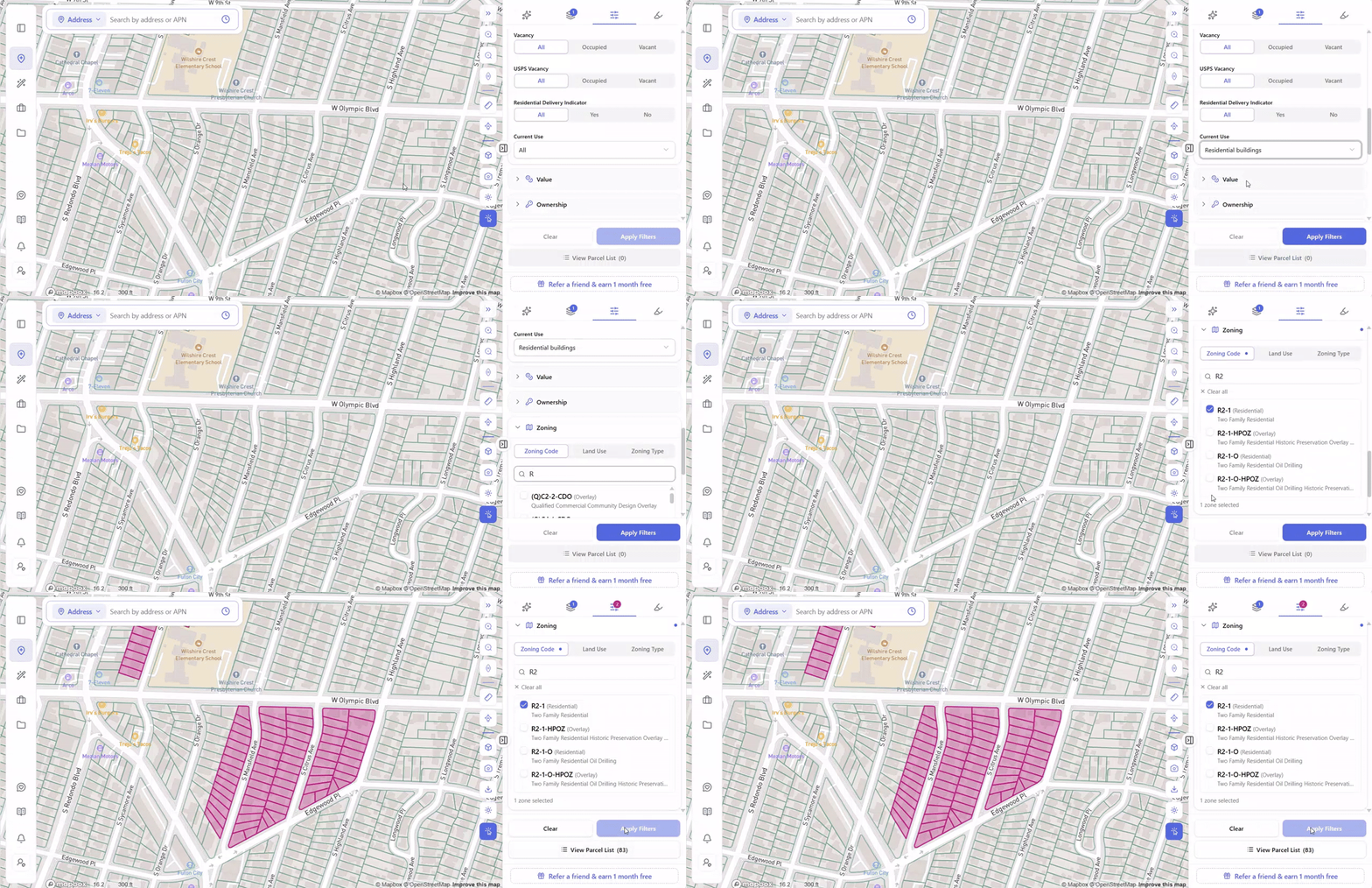
One search, one click, 83 parcels. Then export the list and start calling owners.
A corridor screen that used to take a week of parcel-by-parcel lookups takes an afternoon.
Market first. Addresses second. More on that workflow in How to Find Land for Development with AI.
Where AI Still Stops
AI is not entitlement counsel. For contested rezonings, CEQA-triggered projects and politically sensitive approvals, there’s no replacement for a licensed planning professional with relationships at the agency. Approval odds are probabilities, not guarantees. Cost figures vary by market and should be priced with a local professional.
What AI does is get you to that conversation faster, with the right questions already answered.
The Bottom Line
LA zoning isn’t hard because any one rule is complicated.
It’s hard because a parcel is governed by six documents at once, two of them are different zoning codes, the incentive layer keeps getting rewritten, and the constraints that kill deals aren’t in the zoning string at all.
No developer can hold all that in their head.
What AI changes isn’t that the rules got simpler. It’s that a conflict that used to surface three months into due diligence now surfaces before you write the LOI.
Know what LA lets you build – before you make the offer.