

Every city publishes its own zoning map, with its own portal, vocabulary and ID system. Most due diligence time goes into the translation, not the analysis.
Take three cities as an example – three completely different starting points.
In Los Angeles you use ZIMAS, the city’s Zone Information and Map Access System, searching by address, intersection or Assessor Parcel Number. In New York you use ZoLa, the Department of City Planning’s zoning and land use map, searching by address or borough-block-lot. In Chicago, the city’s zoning map wants a Property Index Number.
Same question – what can I build here – asked three different ways, in three different systems, returning three differently structured answers.
That’s the hidden cost in pre-development research. Not the analysis, but everything before it.
Why There’s No Single Zoning Map
Zoning is local. Every city writes its own code, draws its own districts and builds its own GIS to publish them. The city portals aren’t variations on one tool.
They differ in what they cover. ZIMAS covers properties inside the City of Los Angeles. Everything else falls to LA County’s Z-NET, which serves only areas outside a city – and Los Angeles County contains 88 cities.
They differ in what they carry. ZoLa publishes special purpose districts, Mandatory Inclusionary Housing areas and a Zoning for Accessibility layer. ZIMAS carries specific plans, Historic Preservation Overlay Zones and Community Design Overlays.
And they change. Dallas recently made a new Experience Builder Map Hub its primary public zoning resource and marked its previous zoning map deprecated. Any workflow built around the old one stopped working.
Where the Due Diligence Time Actually Goes
Finding the right jurisdiction
This error costs the most because it’s silent. A Los Angeles postal address can sit inside another incorporated city, or in unincorporated county territory. If the parcel doesn’t appear in ZIMAS, the map isn’t broken – you’re in the wrong jurisdiction, and every rule you were about to apply belongs to someone else’s code.
Learning each city’s grammar
A base zone label means nothing until you know the local conventions, and the conventions are genuinely local.
San Antonio regulates land through 245 zoning districts, and that count comes from a suffix system: CD for a conditional use, S for a specific use, IDZ for an Infill Development Zone, PUD for a planned unit development. They stack, so light commercial appears plain, with a conditional use, with a conditional and specific use together, with an infill zone, and so on.
If you know Los Angeles, that will feel familiar – structurally the same problem as [Q] and (T) conditions, with entirely different letters. The base district is only the start.
The scale differs as much as the vocabulary. Los Angeles maintains 2,120 zoning districts. West Hollywood, sharing a boundary with it, has 25.
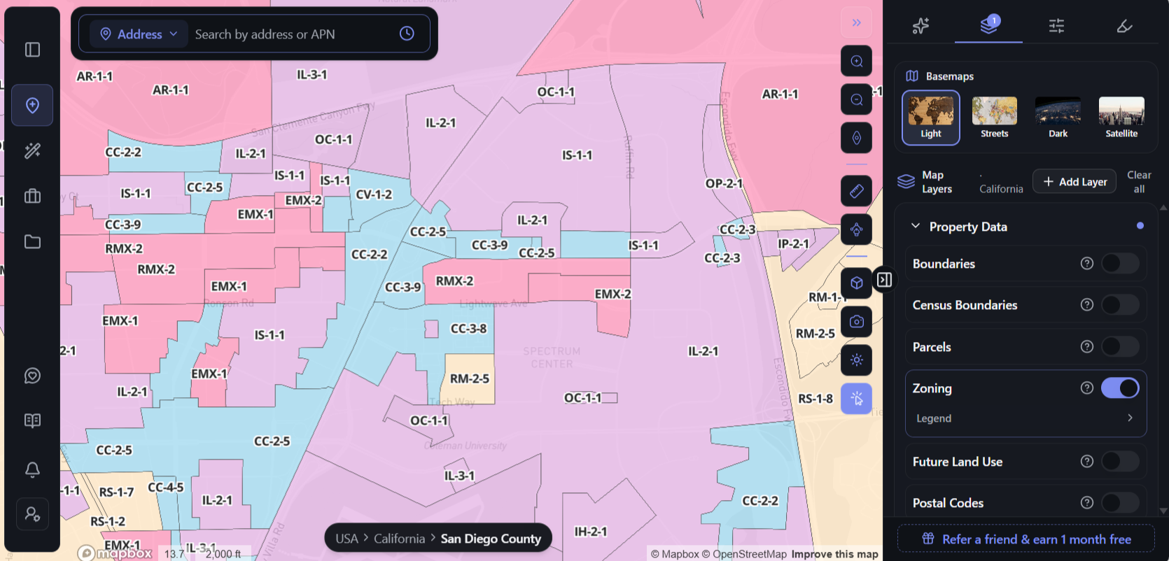
And the districts don’t sit in tidy zones. On a single stretch of San Diego, CC-2-5 runs into IS-1-1, which runs into EMX-1, RMX-2 and IL-2-1 – five different rulebooks within a few blocks, each with its own permitted uses and dimensional standards.
Reading the map, then reading the code
A zoning map gives you a designation. It doesn’t tell you whether your project is allowed. That lives in the municipal code, plus whatever overlay or specific plan sits on top – and LA City Planning notes that most properties across Los Angeles carry some kind of overlay.
Doing it all again in the next market
For a team in one market, that’s a fixed cost paid once. For a team looking at three or four, it’s most of the research effort – and it produces no analysis at all.
What AI Changes About Zoning Research
For most of the last decade, the improvement in zoning research was better maps. Cities moved from paper to GIS, added layers, made them searchable. Useful – but it left the hard part untouched. A map still hands you a designation and leaves you to work out what it means.
What’s changed is that AI can now read the documents behind the designation.
Zoning answers live in text, not on maps. The code section, the overlay ordinance, the specific plan, the state law sitting on top – all written in dense legal language that was never meant to be read quickly. Retrieving the right passages for a specific parcel and turning them into a plain answer is exactly the work that used to take a planner an afternoon.
A category of AI pre-development platforms has grown up to do it. They differ in approach, but the ones worth using share a trait: they don’t answer from general knowledge about what an R3 zone usually allows. They retrieve the documents that govern that parcel and cite the section each answer came from – so you can check the reasoning rather than trust it.
ArchiWise is one of these. Click a parcel and the Zoning tab opens the rules behind the designation. A site on Dathe Street in Dallas comes back as Planned Development District 595 – and underneath that label sit 19 uses permitted as of right, 49 conditional uses, a prohibited list, a maximum FAR of 0.5, a 15-foot front setback, and limits on stories and density, with a link straight to the code section.
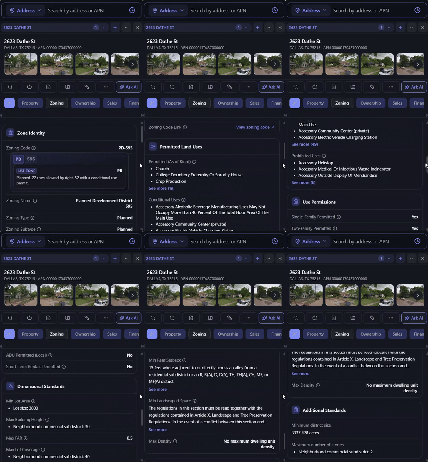
Then ArchiWise AI reads the planning documents themselves – the municipal code, the applicable specific plans and overlays, state housing law – and answers development questions in plain language, with the section attached.
That’s the difference between seeing a designation and knowing what it means.
A Zoning Map for Every City, in One Place
ArchiWise publishes free zoning map pages for cities across the US, organised by state.
Pick a state, pick a city, and the map opens right there – every district colour-coded across the whole city, with the codes on the map. You can see how a jurisdiction is organised before looking at any single parcel: where the commercial spine runs, how the residential tiers step down, where industrial land sits. Alongside it is the full district table for that city, so you can read what each code stands for.
The range is the point. Los Angeles has 2,120 zoning districts. San Diego has 184. West Hollywood has 25, Santa Monica 31, Cudahy 12. Dallas has 1,073; San Antonio has 245. Cities minutes apart, entirely different rulebooks.
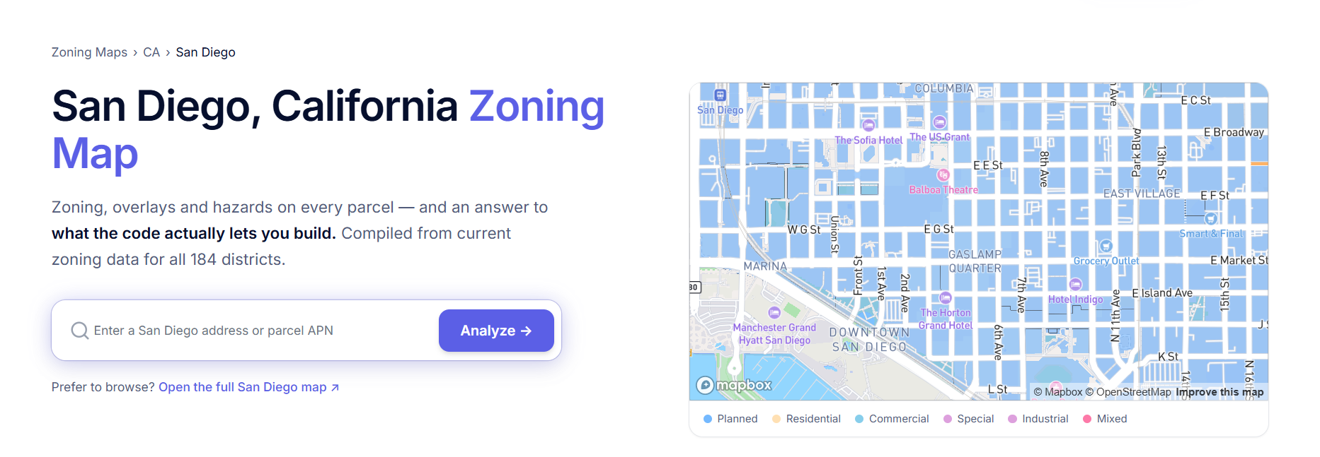
California alone covers 529 cities, including unincorporated county areas – precisely the jurisdiction gap that catches people out.
That gets you the city. For a specific site, enter an address or APN and hit Analyze – the parcel opens in the live app with its zoning and parcel details, and some of the data is free to view, including incentive eligibility like Qualified Census Tract, DDA, SB 79 transit-oriented development and Opportunity Zone status. A plan unlocks the rest.
From Map to Answer
The city pages solve the finding problem. The platform solves what comes after.
One search, not three ID systems. Search by address or APN anywhere; the platform handles the lookup.
Criteria instead of addresses. Draw a search area and filter everything inside it – lot size, current use, value, ownership type, zoning code, hazards. That turns what is this parcel into which parcels fit, the argument we make in AI Site Selection vs Manual Parcel Screening.
The rules, not just the designation. Every figure comes back with the code section behind it, which is the whole point of Municipal Code Interpretation Using AI.
For the Los Angeles version of all this, see our guide to Los Angeles zoning codes and the ArchiWise vs ZIMAS comparison.
Frequently Asked Questions
Is there a national zoning map for the United States?
No official one – zoning is set locally and every city publishes its own. ArchiWise compiles city zoning maps across the US in one place, organised by state.
How do I find the zoning for a property?
Confirm the jurisdiction first, then use that city’s zoning map. You’ll need the right identifier – APN, BBL or PIN depending on the city – and you’ll need to read the base zone together with any overlays, suffixes or specific plans.
Why doesn’t my address show up on the city’s zoning map?
Usually because the parcel isn’t in that jurisdiction. A postal address can belong to a different incorporated city or to unincorporated county territory.
Does a zoning map tell me what I can build?
Only partly. It gives the designation. What’s permitted comes from the code and any overlay, suffix or specific plan layered on top.
Are the ArchiWise city zoning maps free?
Yes. Browse the colour-coded map and the full district table for any covered city. Analysing a specific parcel opens the live app, where some data is free to view and a plan unlocks the full record.
The Bottom Line
City zoning maps are good tools. The problem isn’t any one of them – it’s that there are thousands, each with its own portal, vocabulary and identifier, and a developer working across markets pays the learning cost every time.
Most due diligence time goes into finding and translating information, not judging it. Collapse the finding and the translating, and what’s left is the decision.
One map. Every parcel. The rules that actually apply.