

California Governor Gavin Newsom declared a statewide state of emergency on Monday, September 21, 2026 , mobilizing state resources ahead of an El Niño that forecasters say could become the strongest in recorded history.
The forecast behind the declaration is stark. Federal forecasters give this fall and winter more than a 90% chance of a very strong El Niño, and a 75% chance of one reaching historic strength. Along the equator, the Pacific is warmer than at any point on record – roughly 5.4 degrees above average.
The declaration is about preparation, not an emergency already underway. The state is getting ready for the storms expected this winter.
State agencies are directed to lead flood-risk reduction and stage sandbags, pumps and other equipment. Caltrans will position road-closure and snow-removal gear along the most vulnerable highways, and the National Guard stands ready for flood response and search and rescue. Agencies can also buy emergency materials without the usual competitive bidding, and permits are being fast-tracked for work that reduces storm damage – like erosion control on burned hillsides and clearing sediment from flood channels.
“We are not waiting for this season’s storms to be on our doorstep,” said Cal OES Director Caroline Thomas Jacobs.
The same day, the governor proclaimed separate emergencies to support recovery from earlier storms in Glenn, Humboldt, Kern, Mendocino and Santa Barbara counties.
For developers, this is more than a weather story. The risks the state is preparing for are the same ones that turn a promising parcel into a problem – and the time to find them is before the offer, not after the first storm.
One point worth being clear about: as described by the governor’s office, the accelerated permitting is aimed at preparing for flooding, landslides and debris flows – not at new development generally.
Below, we look at what this emergency means for sites in development – and five risks worth checking before winter arrives.
The Risks the State Is Preparing For
The state’s warning list is specific: repeated heavy rain, strong winds, mountain snow, flooding, landslides, debris flows, large waves and coastal flooding – especially when storms hit during very high tides.
Some of it has already started. California has seen coastal flooding this year linked to El Niño, as Kelvin waves raise sea levels and offshore hurricanes fed by warm Pacific water drive heavy surf onto the coast. Several counties declared local emergencies after tropical storms sent high surf into Southern California and eroded beaches.
And the forecast leans south. The southern half of the state faces a higher chance of above-normal rainfall.
Five Things to Check on Any California Parcel This Winter
1. The Mapped Flood Zone
Start with the obvious one – still the check most often left to due diligence. Is the parcel in a FEMA special flood hazard area? That shapes insurance, lending and design, and this winter it raises the odds of a site or access problem mid-construction.
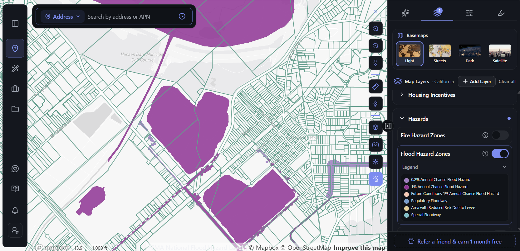
Mapped flood zones don’t always sit where you’d expect. Around Hansen Dam near Pacoima, a U.S. Army Corps of Engineers dam in the San Fernando Valley, FEMA’s mapped flood zones don’t stop at the basins – they follow the drainage channels that run between residential blocks. The layer shows the full range of FEMA designations, from the 1% annual chance flood hazard to regulatory floodways and areas protected by levees.
But flood maps have limits. They show mapped river and coastal flooding, not every local drainage problem – and they don’t show debris flow at all. A clear flood zone is a starting point, not a verdict.
2. What’s Burned Upslope
This is the risk that never appears on a flood map. The state’s own guidance tells residents to check whether their home or workplace sits downslope of an area recently affected by wildfire, where heavy rain raises the risk of flooding, debris flows and mudslides.
In Los Angeles County, that makes the January 2025 fires directly relevant – the ones that devastated Pacific Palisades, Malibu and Altadena. Burned hillsides shed water and sediment far faster than vegetated ones. And the parcels most at risk aren’t necessarily the ones that burned – they’re the ones below them.
3. Slope
Landslides and debris flows are gravity problems. The grade of a parcel, and of the land around it, matters as much as its zoning. A flat map hides it completely – a hillside lot and a level one look identical from above.
4. Coastal Exposure
Coastal sites face compounding risk this season: storm waves arriving on top of sea levels already raised by El Niño, at their worst during the highest tides. For a coastal parcel, the question isn’t only the flood zone – it’s wave exposure and erosion along the frontage.
5. Access and Infrastructure
A sound site can still be cut off. The state warns of roads closed by flooding or rockslides, power outages, and neighbourhoods cut off. If a project plans to grade, pour or build through the winter, the access road and utility connections matter as much as the lot itself.
Screen the Corridor, Not Just the Parcel
All five of those checks have the same problem: the information exists, but it’s scattered. Flood zones sit with FEMA, fire history with state agencies, terrain in survey data, and the rest across county portals – each with its own map and its own format. Checking one parcel at a time across all of them is exactly how hazards slip through to due diligence.
That’s the gap AI pre-development platforms are built to close. Instead of researching sites one address at a time, they bring hazard, terrain and parcel data onto a single map, so a developer can screen a whole area before anything reaches the shortlist. In a winter like this one, that shift – from checking a site to screening a market – matters more than usual.
ArchiWise is one of these platforms. Here’s what that looks like in practice.
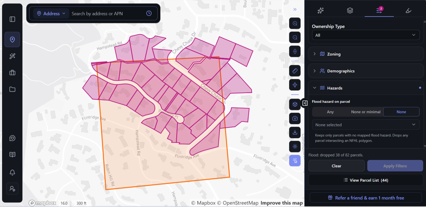
The Hazards filter screens flood exposure and mapped wetlands directly. Set flood hazard to None and it keeps only parcels with no mapped flood hazard, dropping any parcel that intersects FEMA’s National Flood Hazard Layer.
On a hillside search area in La Cañada Flintridge, around Chevy Chase Drive and Flintridge Avenue, it drops 38 of 82 parcels – nearly half – leaving 44 that clear FEMA’s map. The ones removed never reach the shortlist.
On any single parcel, the Hazards tab returns flood zone, fire hazard severity, seismic, methane, past wildfire history and fault proximity together, each rated Clear, Moderate or High.
For the burn-scar question, two tools work together. Past wildfire history shows whether land has burned since 2010 – worth checking on the parcels uphill, not just the site. The terrain layer generates 2-foot contours, and 3D measurement returns elevation and slope estimates along any line you draw, so you can see which way the ground falls. Side by side, they help answer the state’s question – is this site below a recent burn? – before anyone drives out to look.
Seeing those risks across a whole neighbourhood rather than one parcel at a time is the subject of The Role of Area Intelligence in Multifamily and Mixed-Use Site Selection.
What El Niño Doesn’t Mean
The state is careful to say that El Niño doesn’t guarantee a wet winter or any particular storm – it raises the risk of strong ones.
A strong forecast isn’t a reason to walk away from a good site. It’s a reason to know exactly which risks a site carries before committing – so you can price them in, design for them and schedule construction around them. The developers who come through a hard winter well are rarely the ones who avoided risk entirely. They’re the ones who knew about it before the offer.
Frequently Asked Questions
When did California declare the El Niño state of emergency?
Governor Newsom issued the proclamation on September 21, 2026.
How strong is this El Niño expected to be?
Federal forecasters give it more than a 90% chance of being very strong and a 75% chance of reaching historic strength.
Does the emergency speed up development permits?
Based on the governor’s announcement, the accelerated permitting targets preparation for flooding, landslides and debris flows, such as erosion control and flood-channel work – not new development in general.
Does a FEMA flood map show debris flow risk?
No. Debris flow risk depends largely on what sits upslope – especially recently burned land – and on terrain. A flood zone designation captures neither.
What should developers check on a California site this winter?
Five things: the mapped flood zone, whether the site sits below a recent burn area, slope, coastal exposure, and whether access roads and utilities will hold up in a major storm.
The Bottom Line
California is preparing early for what could be the strongest El Niño on record. Developers should too – not by pulling back, but by knowing precisely what each site is exposed to while there’s still time to act on it.
Know what a site is exposed to before the storms do.