

The expensive errors in development aren’t made during construction. They’re made in the weeks before anyone signs anything.
By the time a project breaks ground, most of its economics are already fixed. The price was set, the site was chosen, the zoning was assumed, and the constraints were either known or they weren’t. Everything after that is execution.
Which is why the costliest mistakes happen in pre-development – the stretch where a parcel is being evaluated, a number is being formed, and nobody has committed anything yet. Errors made there don’t announce themselves. They surface in due diligence, at a hearing, or in a permit rejection, long after the money has moved.
Below are ten pre-development mistakes that keep repeating. None of them come from carelessness – they come from information that’s scattered across agencies and portals, and arrives too late to change the decision. Which is exactly the gap AI site selection and pre-development platforms have been built to close.
So alongside each mistake is what it actually costs, and how AI-powered pre-development analysis surfaces the thing you’d otherwise miss – before the offer rather than after it.
1. Starting From Addresses Instead of Criteria
Most site searches begin with a list – parcels a broker sent, listings that appeared, something someone mentioned. Every one of those sites is already known to your competitors.
The structural problem is that address-first research can only evaluate what has already been surfaced. You can’t set criteria and get back matching parcels. The underutilized lot with improvement value far below land value, the property held for thirty years by an owner nobody has approached – neither arrives with an address attached, so neither gets looked at.
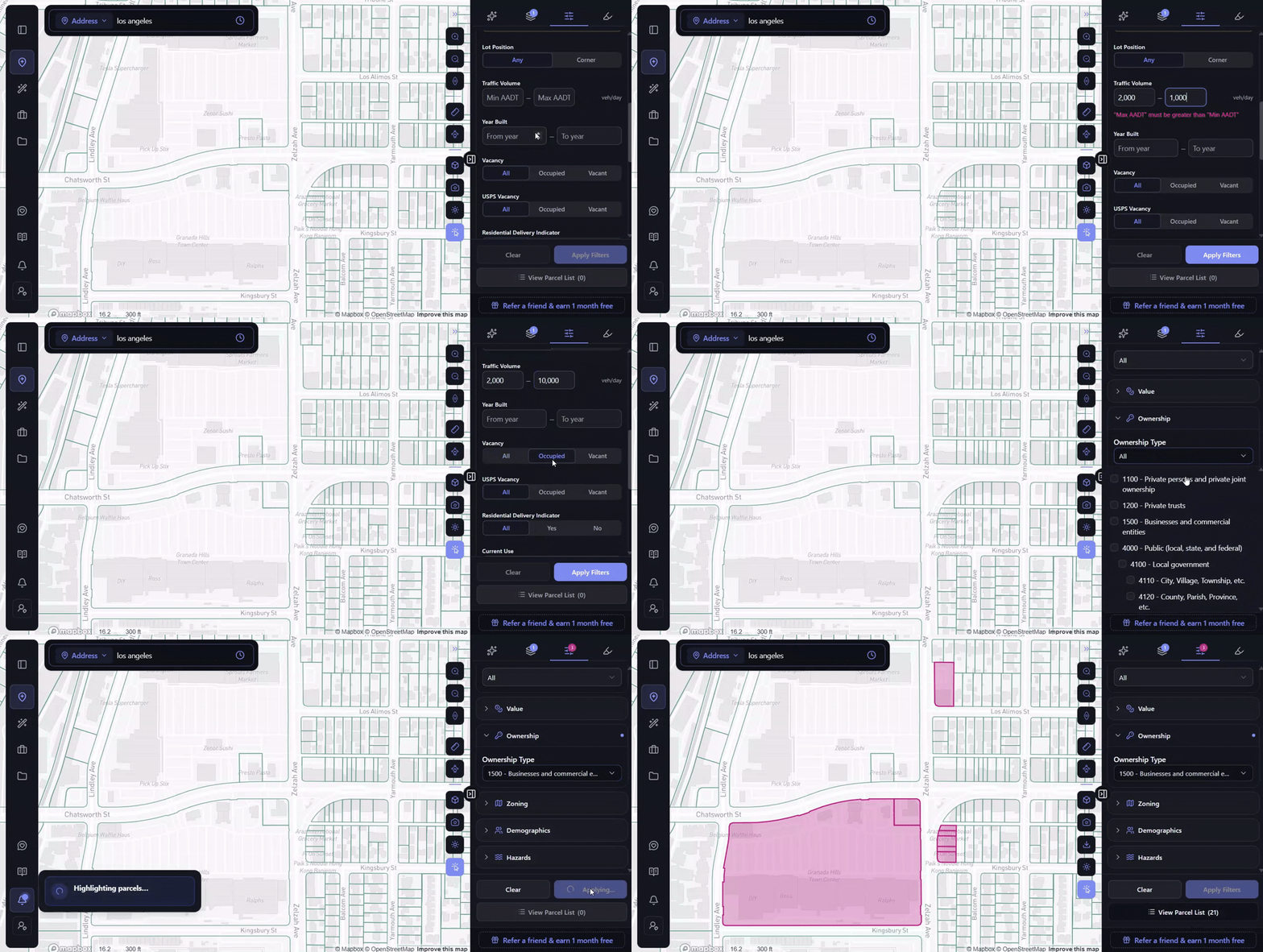
Instead: define the buy box first and screen the market against it. Draw a search area around a corridor, or simply filter everything in your current map view, then stack your criteria – lot size, use, value, ownership type, zoning, even the daily traffic volume passing the site.
On a search around Chatsworth Street and Zelzah Avenue in Granada Hills, three filters, including 2,000 to 10,000 vehicles a day and occupied parcels only, return 21 parcels, with the Granada Hills Town Center among them. Sites that match surface whether or not anyone has listed them.
We broke that comparison down step by step in AI Site Selection vs Manual Parcel Screening.
2. Reading the Base Zone and Stopping There
A zoning designation is rarely one rule. It’s a stack – base zone, height district, overlay, [Q] conditions imposed by ordinance, specific plan – and the most restrictive layer governs, not the one in the zoning string.
Take commercial land on Wilshire Boulevard inside the Park Mile Specific Plan. The commercial base zone suggests one thing. The ordinance says something else: buildings limited to three stories and 45 feet, FAR capped at 3:1, lot coverage at 50%, stores and restaurants expressly prohibited, and Design Review Board approval required on everything but single-family housing.
A developer pricing that site off the base zone is wrong on height, use, coverage and process simultaneously.
Instead: treat the zoning string as the start of the question. Confirm whether a specific plan or overlay applies before any number reaches a pro forma.
3. Assuming State Law Applies the Way the Headlines Said
California’s SB 79 took effect statewide on July 1, 2026, allowing up to nine stories by right near heavy rail. Los Angeles then adopted two ordinances on June 23, effective June 30, that pause SB 79 citywide and defer full implementation to roughly 2030 – replacing it with a Low-Rise Ordinance permitting two to four stories across 57 Opportunity Station Areas.
A developer who read a national explainer and priced an LA site at nine stories near a Metro stop is working from the wrong document entirely.
Instead: check what the local jurisdiction actually adopted, not what the state enabled. State law sets a ceiling. Cities decide how and when it lands.
4. Leaving Hazards to Due Diligence
Fire severity, flood zone, seismic, methane, fault proximity – these typically surface after earnest money is committed, because each lives in a different agency portal and nobody checks four portals for a site that might not work out.
Methane is the clearest case. It never appears in a zoning designation, and under LAMC Division 71, Section 91.7101, LADBS can withhold a building permit until adequate mitigation is designed. A parcel can pass every zoning check and still carry a serious mitigation requirement.
Instead: screen hazards during evaluation, not diligence. Found at screening, walking away costs nothing. Found after earnest money, it costs everything already spent. More on that case in Methane: The Site Hazard Hiding in Plain Sight.
5. Treating Historic Overlays as a Design Problem
Developers often read a historic designation as a constraint on aesthetics – a longer approval, some review on materials. In practice it can decide the economics.
Los Angeles has 35 Historic Preservation Overlay Zones, each with its own preservation plan and review board. And HPOZ status now determines more than design review: HPOZs were largely excluded when LA expanded its Low-Rise incentives in June 2026. The same parcel, inside or outside an HPOZ boundary, is two different deals.
Instead: check overlay status before underwriting – and check what the overlay excludes you from, not just what it requires of you.
6. Checking One Incentive Program Instead of the Stack
Most teams check the program they already know. But eligibility is rarely singular. A parcel might qualify under a local density bonus, a transit incentive, a state streamlining law and a federal designation at once – and the programs interact.
The federal layer is the most commonly missed, because it isn’t on any city map. Qualified Census Tract status unlocks a 30% LIHTC basis boost on an affordable project, which can be the difference between a deal that pencils and one that doesn’t. Nearby LIHTC precedents tell you whether that financing pathway has actually worked in the neighbourhood.
Instead: screen the full stack at once – local, state and federal – and ask specifically how the programs combine, not just whether each applies.
7. Judging Owners by Name Instead of Signal
Pulling an owner name from the assessor’s portal answers one question and leaves the important one untouched: is this owner likely to sell?
A name tells you nothing. The picture around it tells you a great deal – how long they’ve held, how many other properties they own, how leveraged those properties are, whether they live there, and whether anything is pushing them.
A trust holding a building for 31 years with almost no debt against a $2.6M portfolio, owner absentee, is a specific and readable situation. A thirty-one-year hold carrying a tax delinquency and a pre-foreclosure flag is a completely different one. Both look identical in a listing.
Instead: treat ownership as a screening dimension. Hold period, portfolio leverage, absentee status and distress indicators together tell you where outreach is worth spending. That’s the mechanism behind most off-market deal flow, which we covered in Why Off-Market Deals Stay Off-Market.
8. Finding Out About Infrastructure After the Offer
Gas pipelines, transmission corridors and sewer capacity are usually discovered by calling utilities – a process that runs on their timeline, not yours, and typically delivers answers weeks into due diligence.
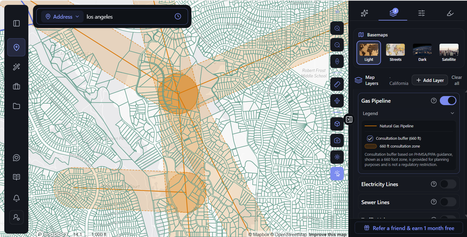
Pipelines carry a specific procedural risk. PHMSA’s Pipelines and Informed Planning Alliance recommends that local governments adopt a consultation zone of 660 to 1,000 feet either side of a natural gas transmission line, requiring developers to consult the pipeline operator early in planning. These practices aren’t federally mandated – they apply where a local ordinance has adopted them, and the distance isn’t a setback. But where they do apply, they add a consultation step and potentially design requirements that are far easier to absorb at screening than after a site is under contract.
In parts of the northern San Fernando Valley, several natural gas pipelines converge beneath ordinary residential streets – and where their consultation zones overlap, a single lot can sit inside more than one.
Instead: look at infrastructure proximity while the site is still a candidate. It’s map data, available before anyone picks up a phone.
9. Ignoring Topography Until Design Begins
Slope analysis usually waits for a survey or a CAD workflow, which means it happens after a site is already under serious consideration. By then, grading costs are a surprise rather than an input, and hillside ordinance triggers arrive late.
Flat maps make it worse, because they hide grade entirely. A hillside lot and a level one look identical from above.
Instead: measure elevation and slope during screening. Drop a few points across a parcel in 3D and the readings come back immediately. On one 163-foot line across a hillside street, elevation runs from 1,347 to 1,375 feet – 28 feet of change – with slope reaching 19.8 degrees at its steepest.
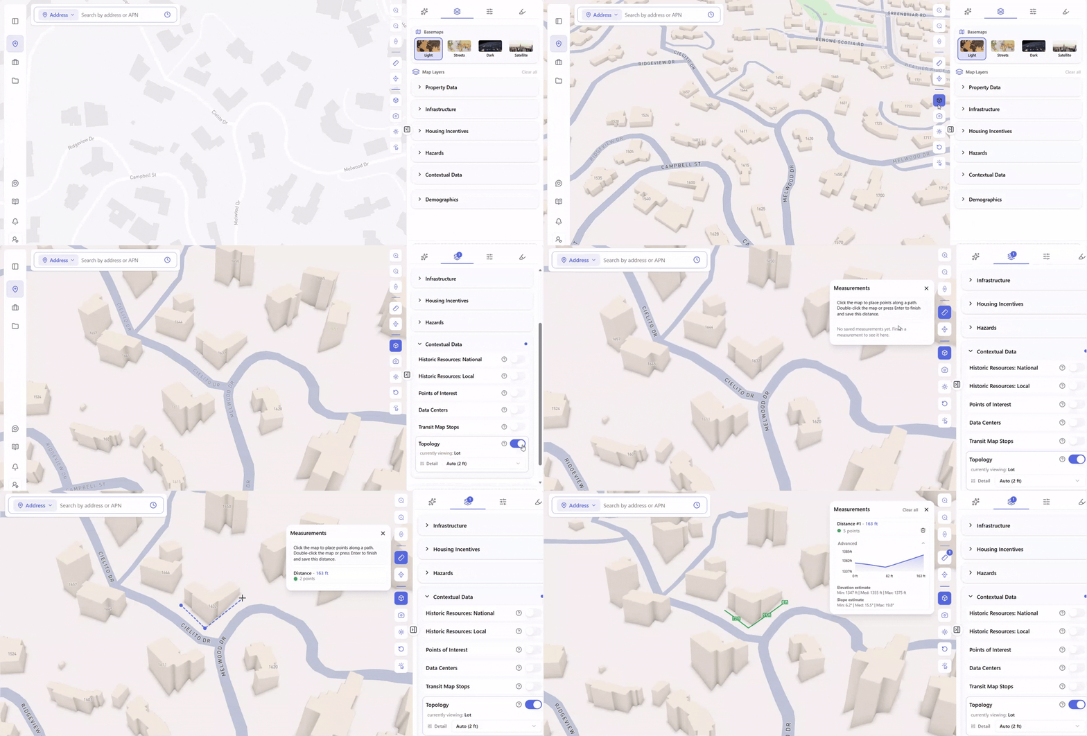
That’s the difference between a flat pad and a stepped foundation, and it belongs in the offer, not the design phase.
10. Asking General AI Instead of the Actual Documents
More developers now put pre-development questions to general-purpose chatbots. The answers come back fast and fluent – and they’re built from whatever the model absorbed in training, not the documents that govern your parcel.
That matters because a pre-development question is rarely just about zoning. What a site allows depends on the zoning code, any specific plan covering the area, overlay districts, state housing laws like SB 9 and SB 35, ADU rules, and the incentive programs layered on top. A general chatbot can’t tell you which of those apply to a particular parcel, and it won’t tell you when it’s guessing.
Instead: use AI grounded in the real sources. ArchiWise AI answers pre-development questions for the parcel you’re looking at by reading the documents that actually govern it – the municipal zoning code, the relevant specific plans and overlays, state housing law, and state ADU guidance – and cites the section behind every figure, so any answer can be checked in a minute.
It also works from what’s current. Los Angeles passed two significant ordinances in June 2026 alone, and an answer is only as good as the documents behind it. We unpack the difference in Zoning with AI.
The Common Thread
Nine of these ten are the same mistake wearing different clothes: information that exists, but arrives too late to change the decision.
The zoning overlay, the methane zone, the pipeline consultation zone, the HPOZ boundary, the incentive stack, the slope under the lot, the owner’s actual situation – none of it is secret. It’s scattered across agencies, portals and databases, each with its own interface and its own timeline, which in practice means it gets checked after commitment rather than before.
Pre-development platforms exist to close that gap. ArchiWise covers every parcel in the United States, screens by criteria rather than address, and assembles zoning, hazards, incentives, infrastructure, ownership and value in a single view – grounded in the planning documents that govern each parcel and cited to the section each answer came from.
The tenth mistake is the exception, and worth stating on its own: speed without sourcing is its own risk. A fast wrong answer is more dangerous than a slow one, because it feels finished.
Frequently Asked Questions
What is pre-development in real estate?
Everything before construction begins – site identification, zoning analysis, hazard and infrastructure screening, incentive eligibility, ownership research and feasibility testing. It’s where a project’s economics are effectively decided.
What’s the most expensive pre-development mistake?
Discovering a constraint after earnest money is committed. Overlay conditions, hazard exposure and entitlement complexity found during screening cost nothing to walk away from. Found in due diligence, they cost everything already spent.
How long should pre-development research take per site?
Manually, most teams spend the better part of a day per parcel across zoning, hazards, incentives, ownership and value, and about a week for ten candidate sites. What matters more than the total is that most of that research produces rejections.
Can AI replace a planning consultant?
No. For contested rezonings, CEQA-triggered projects and politically sensitive approvals there’s no substitute for a licensed professional with relationships at the agency. What changes is how well-informed you are walking into that conversation.
The Bottom Line
These mistakes come from a process where information arrives in the wrong order – after the offer instead of before it, in due diligence instead of at screening, from a confident answer instead of a cited one.
Fix the order and most of them stop happening.
Know what a site actually allows before you make the offer.