

A week of site research is mostly spent proving that sites don’t work. Here’s what changes when that week becomes an afternoon.
Think about the hours on your last land search – not the deal you closed, but the forty parcels you looked at first. The zoning portal, the FEMA map, the assessor’s site, the federal database for the census tract, the call to planning that took two days to come back. Then the next parcel, and the same sequence again.
Most teams spend the better part of a day per site, and roughly a week for ten. What never shows up in a budget is that most of that week produces a no. The research that kills a site costs exactly what the research that saves one costs, and you do far more of the first kind.
That’s the real expense of manual site selection. It isn’t just slow – it’s slow at producing rejections, which is most of what it produces.
Where the Week Goes
Manual screening looks like one job. It’s six, and each has its own portal, its own format and its own way of failing.
It starts with finding a candidate, which means you already need an address from a broker, a listing or a tip. Then the zoning: find the parcel on the planning portal, identify the designation, pull the code section, cross-reference height districts, overlays and any [Q] conditions layered on top. On a complicated site that step alone runs hours.
Hazards come next, and they’re scattered. Fire hazard severity sits in one agency portal, flood zone in another, seismic somewhere else, methane somewhere else again – four interfaces, four data formats, and no way to see how any of them overlap on a single parcel. Incentives are no better: TOC tier on a city map, QCT status in a federal database, DDA designation elsewhere, state programs across separate pages.
Then ownership, through the county assessor one APN at a time, which usually gives you a name, often without a mailing address, and never any indication of whether that owner would actually sell. And finally the numbers – assessed value, last sale, improvement value – pulled by hand, parcel by parcel.
Six tasks for one site, repeated across forty.
Manual screening makes the no as expensive as the yes.
The Constraint Underneath the Clock
Speed is the visible problem. The structural one is where the process has to start.
Manual research begins with an address, which means it can only evaluate what someone has already put in front of you. You can’t set criteria and get back a list of matching parcels, and you can’t screen a corridor you have no addresses in. The whole process is reactive by design – a broker calls, you respond, and the parcel nobody called about stays invisible.
That’s usually where the good sites are. The underutilized parcel with improvement value far below its land value. The long-held property whose owner has never been approached. The institutionally-owned site sitting in exactly the right zone. The incentive-eligible parcel that only pencils because of a designation you’d have to know about in advance to check for. None of these arrive with an address attached.
A category of software has grown up to fill that gap. AI pre-development platforms work in the opposite direction to a listings portal: rather than showing you what someone decided to market, they let you describe what you’re looking for and return every parcel that matches, listed or not. Some handle one piece of the problem – zoning interpretation, or hazard mapping. Others pull the whole pre-development picture into one place.
ArchiWise is one of these. It covers every parcel in the United States, screens by criteria rather than address, and assembles zoning, hazards, incentives, ownership and value in a single view.
The parcels these platforms surface are the ones that never reach a broker, and there are structural reasons for that, which we covered in Why Off-Market Deals Stay Off-Market.
What ArchiWise Is
ArchiWise is a nationwide pre-development intelligence platform built for developers, architects and brokers working infill and multifamily projects.
ArchiWise AI is a single chat that answers pre-development questions for whichever parcel you’re asking about, grounded in the planning documents that actually govern it and cited to the code section each figure came from. The same chat also finds and filters parcels across an entire market. Area Intelligence layers hazards, infrastructure, incentives and demographics onto the map from federal, state and local sources. Feasibility Analysis produces massing, program and pro forma through a six-step workflow. Entitlement Viability scores approval risk against real project outcomes by jurisdiction and project type.
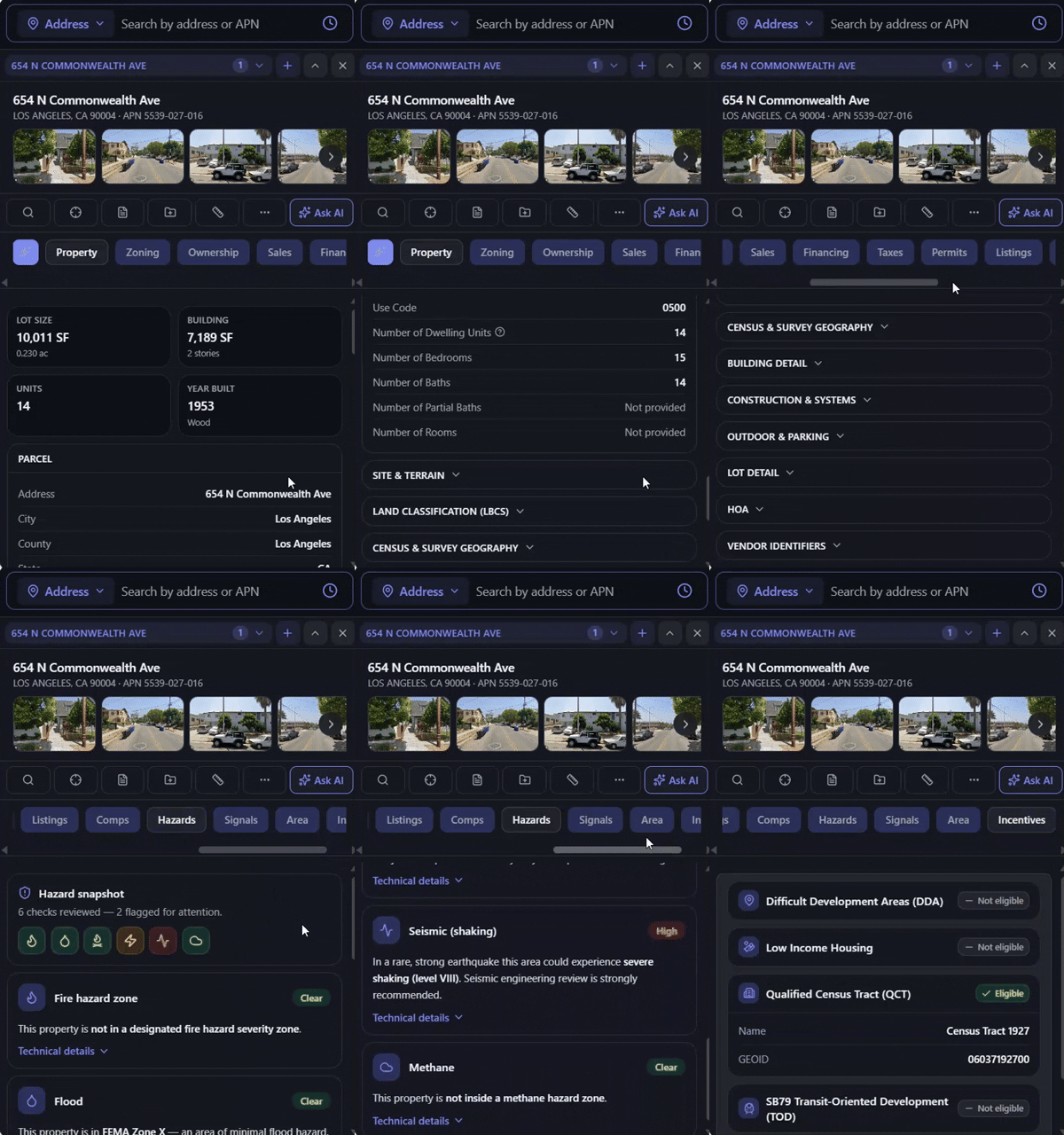
Clicking a parcel opens thirteen data tabs at once – Property, Zoning, Ownership, Sales, Financing, Taxes, Permits, Listings, Comps, Hazards, Signals, Area and Incentives – assembling in seconds what manual research takes days to piece together.
Six Tasks, Collapsed
From addresses to criteria
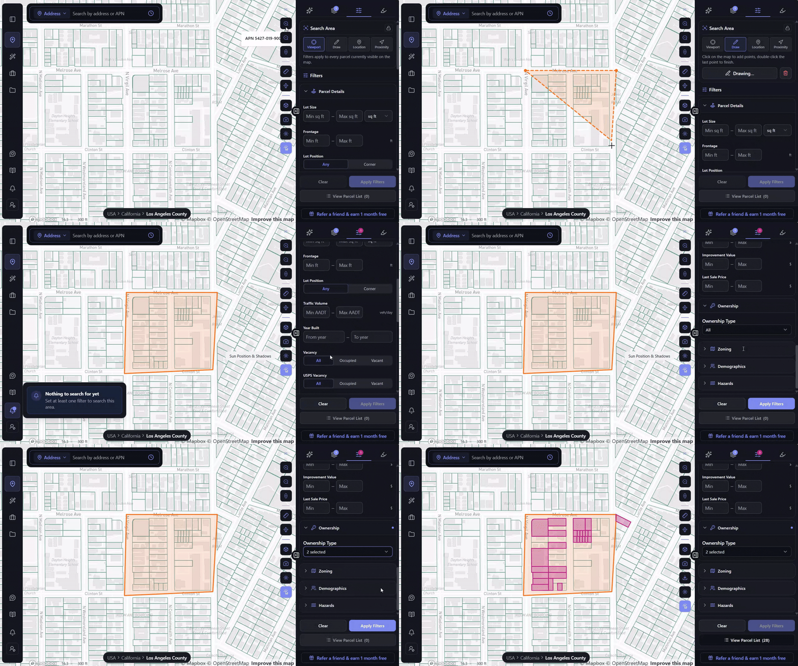
Draw a boundary on the map, open the filter panel, and stack whatever your buy box requires: lot size, frontage, year built, vacancy, current use, improvement value, last sale price, ownership type, zoning, demographics, hazards. Apply the filters and the map narrows to the parcels inside your boundary that match. No address needed anywhere in that process, which is why off-market parcels surface exactly the same way listed ones do.
On a real search along Melrose Avenue in Los Angeles, drawing a boundary across a few blocks and setting ownership type returns 28 parcels, every one of them meeting the criteria and ready to open or export.
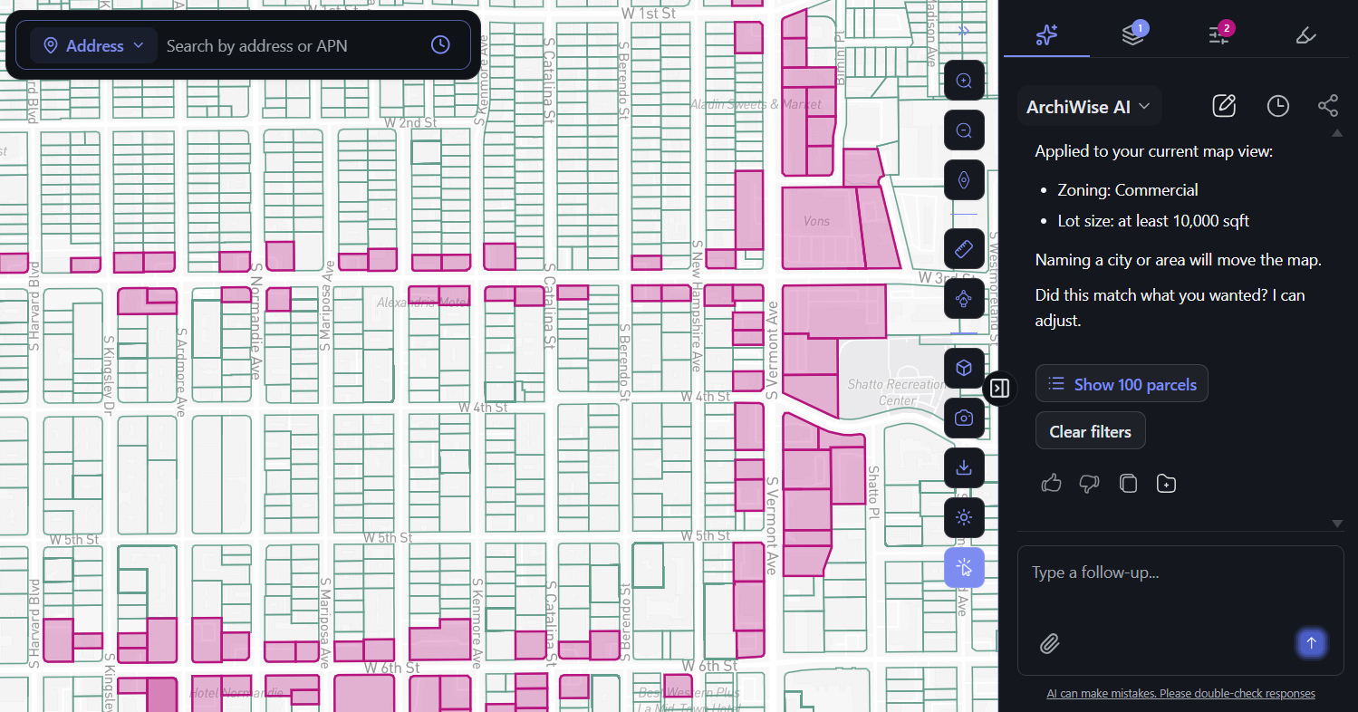
The same search works by typing. Describe what you want to ArchiWise AI and it doesn’t explain what such a search would return – it applies the filter to your current map view and gives you the result. Ask for commercial-zoned parcels of at least 10,000 square feet and it confirms both criteria, shades every match on the map, and puts the parcel list one click away.
More on building a search this way in How to Find Land for Development with AI.
Zoning, hazards and incentives in one place
Click a parcel and the five-portal research is already finished.
The Zoning tab gives the designation, the permitted and conditional uses, and the development standards that follow from them, with a direct link to the applicable code. ArchiWise AI handles follow-up questions in plain language and cites the exact section behind every figure – which is the difference between a tool that knows about zoning in general and one that reads the documents governing this particular parcel. We go into that distinction in Zoning with AI.
The Hazards tab returns flood, fire, seismic, methane, wildfire history and fault proximity together, each with a Clear, Moderate or High badge and technical detail behind it. Done manually, these surface during due diligence – after earnest money. Methane is the clearest example, since it never appears in a zoning designation and in Los Angeles can stop a building permit outright, which we wrote about in Methane: The Site Hazard Hiding in Plain Sight.
The Incentives tab screens QCT status, DDA designation, nearby LIHTC precedents and state programs in a single click.
What One Click Returns
Take one parcel out of that Melrose search: 654 N Commonwealth Ave, Los Angeles 90004.
The Property tab describes the building before anyone has visited it – 7,189 square feet of building on a 0.23-acre lot, currently in use as residential with five or more apartments, with 14 dwelling units, 15 bedrooms and 14 baths. That’s a fourteen-unit building, not a guess about one.
Hazards returns the risk picture without a single agency search. Flood comes back Clear, FEMA Zone X, where insurance typically isn’t required. Past wildfires are Clear – nothing has burned this parcel since 2010. A mapped earthquake fault runs within about two-thirds of a mile, the Upper Elysian Park fault, with its nearest trace roughly 0.4 miles away. Incentives shows the parcel isn’t eligible as a Difficult Development Area, alongside the rest of the program screen.
Every one of those readings lives in a different agency in the manual version. Seeing them across a whole corridor rather than one parcel at a time is an advantage of its own, which is the subject of The Role of Area Intelligence in Multifamily and Mixed-Use Site Selection.
The Ownership Picture
Manual ownership research answers exactly one question: who owns this parcel. It needs the address first, it returns a name that may or may not come with a mailing address, and it tells you nothing about whether that owner would sell.
ArchiWise turns ownership into something you screen by. You can filter for government-owned parcels, or work through the full ownership-type list, and every result carries the owner picture before you’ve made contact.
For 654 N Commonwealth, the owner is the Quinonez Family Trust – a trust, non-owner occupied, holding five properties worth $2,615,000 in total against just $134,816 of linked debt, leaving roughly $2.48 million in portfolio equity across 14 linked addresses, none of them vacant. The hold period is 31.1 years, and the parcel is flagged a Very Strong Sell Candidate.
Read those together and you get a real picture. A family trust has owned this fourteen-unit building for thirty-one years. The portfolio around it is small and almost entirely unleveraged. Nobody lives there.
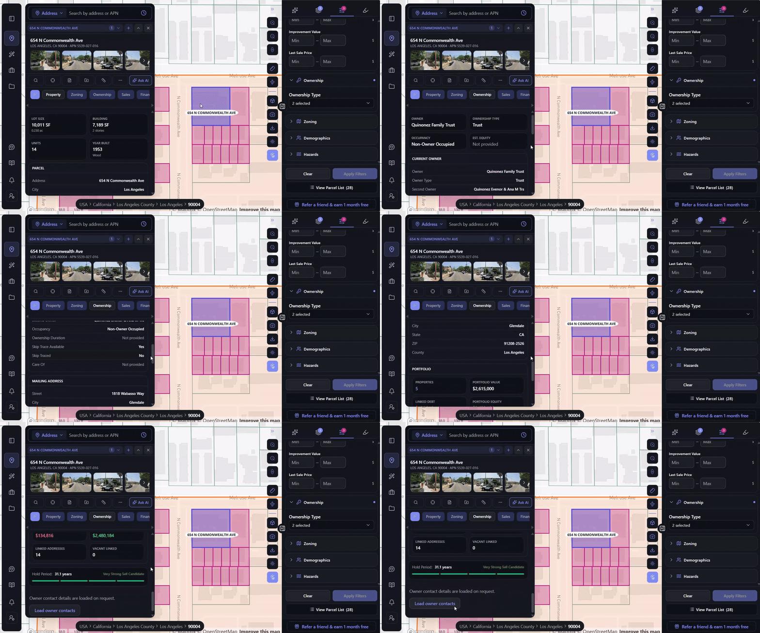
Assembling that by hand means the assessor’s portal for the name, a separate search to find the other properties, recorder’s records for the debt – and no way at all to turn any of it into a rating.
The Signals That Never Reach a Listing
A long hold tells you an owner might be receptive. It doesn’t tell you whether anything is pushing them.
The Signals tab covers that, screening the parcel against distress and verification indicators that exist only in county and postal records – the things a broker has no reason to raise and a listing would never show.
For 654 N Commonwealth, pre-foreclosure, short sale, bankruptcy, pre-probate and tax delinquency all come back Clear, with zero liens and $0 in lien amount across both property and personal liens. The owner is confirmed absentee. USPS vacancy came back negative when it was checked on August 4, 2026, residential delivery is confirmed, and the parcel records were last refreshed on September 16, 2026.
Nothing distressed, nothing encumbered, and an owner who doesn’t live there – verified against postal records with a date attached, rather than inferred from a mailing address.
The combination is what matters. A thirty-one-year hold with no debt, no liens and an absentee owner is a completely different prospect from a thirty-one-year hold carrying a tax delinquency and a pre-foreclosure flag. Both would look identical in a listing, and neither is findable manually without pulling county records one parcel at a time.
What Changes When the Week Becomes an Afternoon
The gain isn’t that each site gets researched faster. It’s that the pipeline changes shape.
A team that can screen dozens of parcels in the time manual research takes for one evaluates far more opportunities and spends its professional hours only on the sites that survive the screen. Those sites also turn up earlier – before they’re listed, before brokers are involved, before competing offers appear, before the owner has thought about selling. The off-market advantage stops being luck and becomes a process.
It changes negotiations too. Walking into a conversation already knowing the zoning, the hazards, the incentive eligibility, the ownership history and the distress picture is a fundamentally different position from knowing two of those things. And the expensive discoveries – overlay conditions, hazard exposure, entitlement complexity – move from due diligence, where earnest money is already committed, back to screening, where walking away costs nothing.
Frequently Asked Questions
How long does site selection take manually?
Roughly a day per site for full research across zoning, hazards, incentives, ownership and value, and about a week for ten candidate sites. Most of that time produces rejections rather than deals.
What makes AI site selection faster?
Two things. Six separate research tasks collapse into one view when a parcel is clicked, and screening starts from criteria rather than an address, so an entire market can be filtered at once instead of researched parcel by parcel.
Can AI find off-market parcels?
Yes, and that’s the structural advantage. Criteria-first screening surfaces any parcel matching your buy box whether or not it’s listed, including long-held and institutionally-owned sites that never reach a broker.
How do you tell whether an owner might sell?
Hold period, portfolio size, leverage and absentee status together give a much better read than a name alone. ArchiWise combines these into a Sell Candidate rating and screens separately for distress indicators – pre-foreclosure, tax delinquency, liens, probate – before any contact is made.
Does this replace due diligence?
No. It moves discovery earlier. Constraints that would otherwise surface after earnest money surface during screening instead. Formal due diligence and professional review still follow.
The Bottom Line
Site selection doesn’t take weeks because any single lookup is difficult. It takes weeks because there are six of them per parcel, they live in six different places, and the whole sequence has to repeat for every site – including the thirty-nine that won’t work.
Collapse that into one view, screen by criteria rather than addresses, and the week becomes an afternoon. More sites evaluated, earlier in the cycle, with the full picture in hand before any money moves.
Stop starting from addresses someone else gave you.