
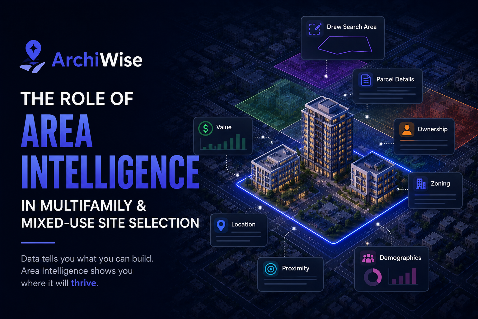

Two blocks, same submarket, same zoning code. One supports a fifty-unit building with a waitlist before the lobby doors go up. The other supports the same fifty units, and half sit empty a year later. The zoning code can’t tell you which block is which.
That’s the gap Area Intelligence exists to close – and multifamily and mixed-use projects feel it more than almost any other property type.
Why Multifamily and Mixed-Use Need More Than a Zoning Check
A single-family lot succeeds or fails on its own terms – the house, the yard, the school district. A multifamily building’s success is tied to the neighborhood around it: how many renters live within reach, whether the submarket’s rents support the debt service, whether a hazard is about to change the insurance line item before the pro forma closes.
Mixed-use adds a second layer of exposure. A ground-floor retail component only works if there’s foot traffic, transit access, and a customer base nearby – not just a zoning code that permits it. Clearing the zoning check and clearing the market check are two separate questions, and a site can pass the first while failing the second.
This is why multifamily and mixed-use developers pull from more data categories than almost anyone else in real estate before making an offer – demographics, hazards, infrastructure, incentive eligibility, walkability, and use permissions – for a site they haven’t decided to pursue yet.
Why AI Earns Its Place Here
Pulling that many categories together, for every candidate site in a target submarket, used to mean separate agency portals, separate databases, separate calls, assembled by hand, one parcel at a time. That doesn’t scale to “screen an entire submarket.” It barely scales to one address.
AI-powered property intelligence platforms close that gap – not by replacing judgment, but by pulling every relevant dataset into one place and interpreting what it means, instead of just displaying it. A general AI model like ChatGPT or Claude can explain what a Qualified Census Tract (QCT) is or how a density bonus generally works, but it has no live connection to this week’s demographic data or the zoning ordinance governing a specific block – it can’t tell a developer whether a given submarket actually clears the bar. That gap between explaining a concept and answering a parcel-specific, cited question is what a document-grounded platform is built to close.
What Is ArchiWise
ArchiWise is a nationwide pre-development site analysis platform for developers, investors, architects, and brokers, covering every parcel in the United States. It’s built around five solutions – AI Site Selection, AI Zoning Expert, Area Intelligence, Feasibility Analysis, and Entitlement Viability – alongside a single conversational assistant, ArchiWise AI, that answers every kind of question in one thread. Ask it about a parcel you’ve clicked, or ask it to find and filter multifamily-eligible parcels across a drawn area, and it reasons through the answer, citing the source it came from.
Area Intelligence is the solution built for the question multifamily and mixed-use developers ask earliest: not “what can I build on this parcel,” but “which parts of this market are even worth looking at.” It layers hazard, infrastructure, housing incentive, demographic, and contextual data directly onto the map – visible across a whole submarket before a single address is chosen.
What Area Intelligence Actually Puts on the Map
Area Intelligence isn’t one layer – it’s several groups of them, toggled directly over the map in ArchiWise’s right-hand panel, so the picture builds before a parcel is ever clicked.
Demographics. Thirteen categories – Median Household Income, Population Density, Median Rent, Rent Burden, Homeownership Rate, Young Adults (18-34), Seniors (65+), College Degree or Higher, Poverty Rate, Labor Force Participation, Unemployment Rate, Six-Figure Households, and Housing Investment Attractiveness. For multifamily, Rent Burden and Homeownership Rate matter most – a high renter share paired with a high rent burden is the demand signal a pro forma needs. Clicking through zip codes on the same map surfaces exactly that contrast: one zip code running high on income and low on rent burden, an adjacent one running the opposite way – the kind of block-to-block variation that never shows up on a single zoning check.
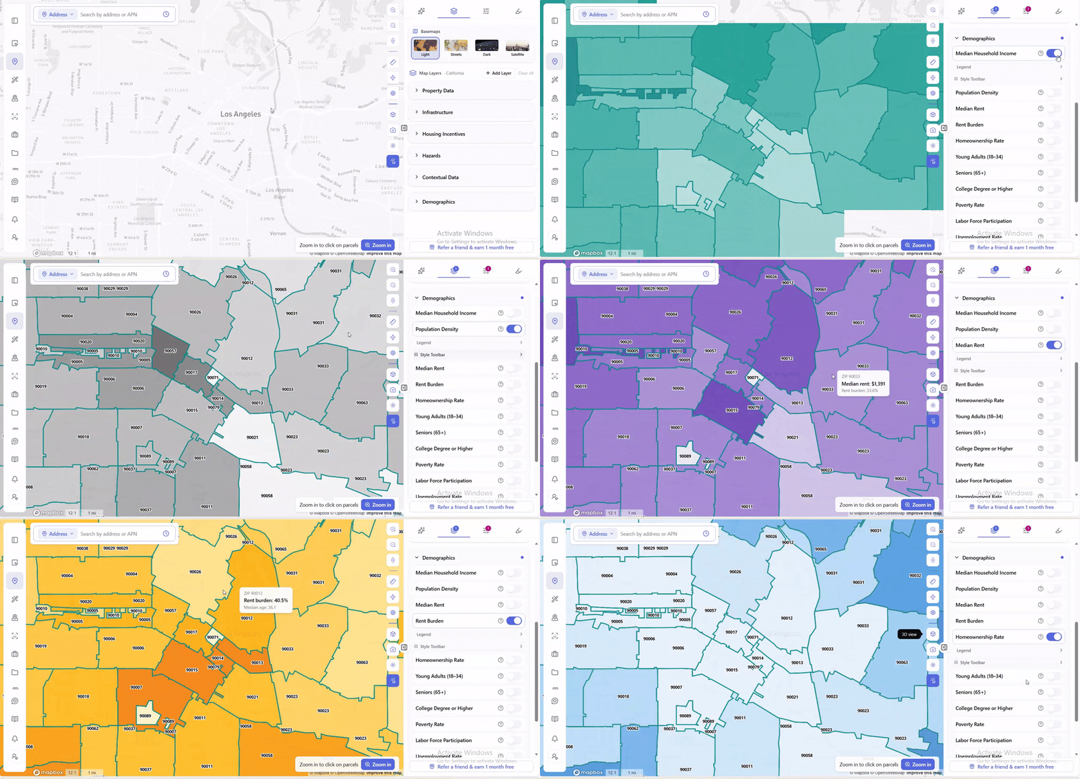
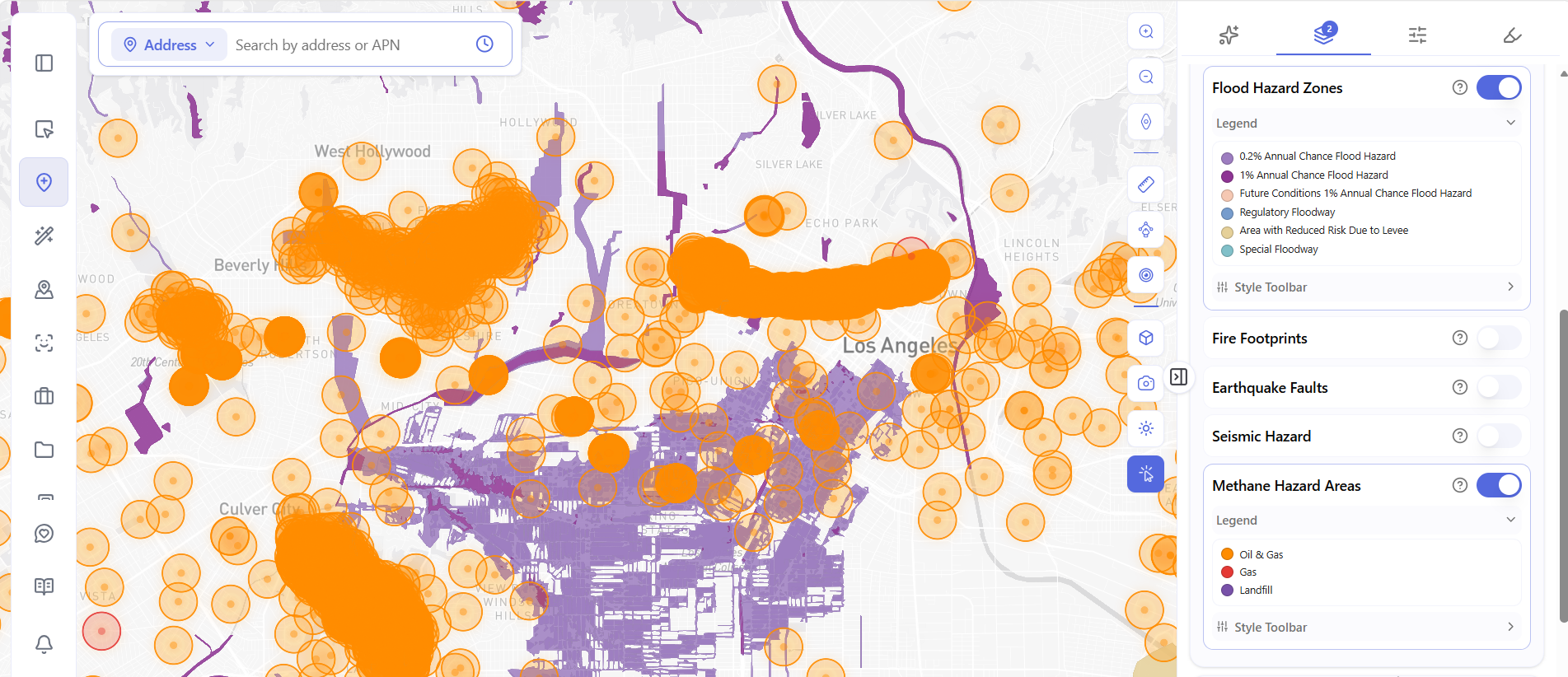
Hazards. Six layers – Fire Hazard Zones, Flood Hazard Zones, Fire Footprints, Earthquake Faults, Seismic Hazard, and Methane Hazard Areas – shown across an entire corridor, not one address. Wildfire risk is tracked through fire agency severity zone designations that classify an area by fire risk, independent of whether a fire has actually occurred there. Flood Hazard Zones alone break into six designations, and Methane Hazard Areas track three source types, so a corridor can show a broad flood zone overlapping a tight cluster of methane sources near a former oil field – two entirely different hazard mechanisms sitting on the same block. Exposure isn’t automatically a deal-breaker – it’s a cost that belongs in the pro forma before an offer goes in, not a surprise discovered after.
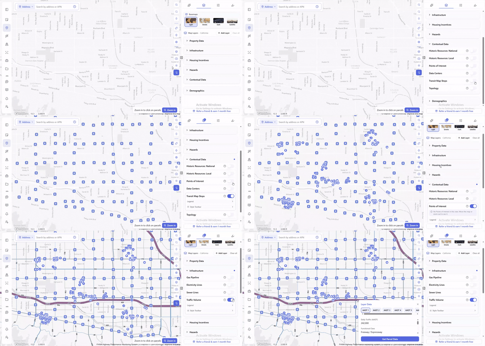
Infrastructure. Gas Pipeline (660-ft PHMSA/PIPA consultation buffer) and Electricity Lines (color-coded by voltage) are both nationwide; Sewer Lines is currently available for Los Angeles. Traffic Volume surfaces annual average daily traffic (AADT) from the FHWA Highway
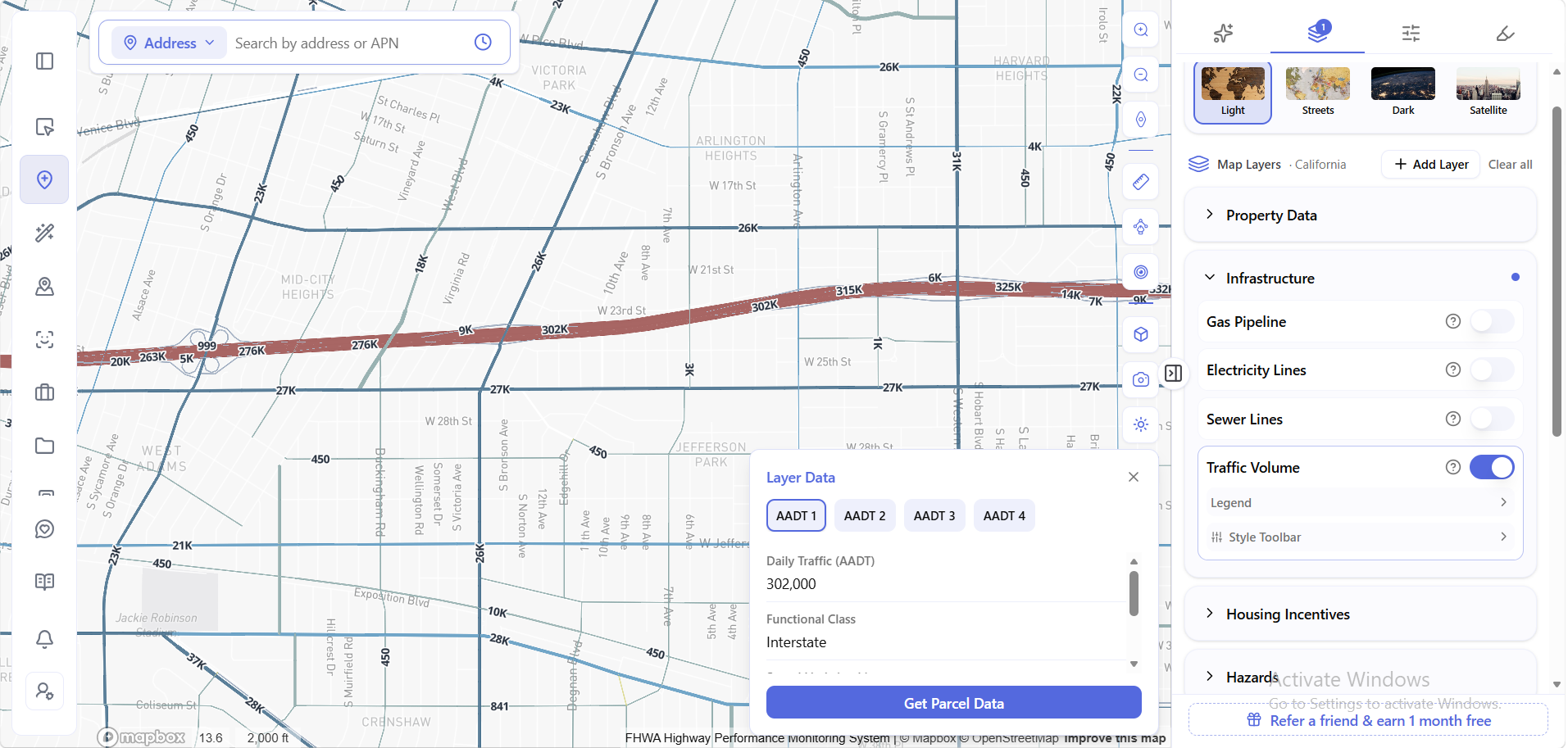
Performance Monitoring System – clicking a road segment returns the exact daily vehicle count and functional class. For a mixed-use ground-floor retail component, that’s a direct proxy for drive-by visibility a zoning code has no way of expressing. A multifamily building also needs sewer and electrical capacity a single-family lot never accounted for.
Housing Incentives. Difficult Development Areas (DDA) and Qualified Census Tracts (QCT) – both federal HUD designations – plus Low Income Housing precedent and Transit-Oriented Development eligibility. Stacking incentives changes what a project can pencil at, and shading both layers over the same submarket makes the overlap visible directly – broad DDA coverage with QCT sitting in smaller, more specific pockets inside it. A parcel in that overlap can potentially stack both designations; a parcel a few blocks outside may qualify for neither.
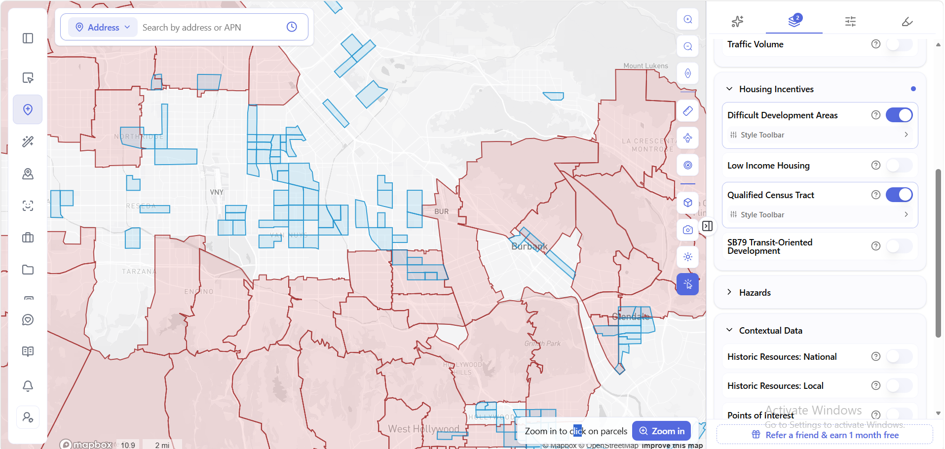
Contextual Data. Six layers – Historic Resources: National, Historic Resources: Local, Points of Interest, Data Centers, Transit Map Stops, and Topology. Points of Interest is the one that matters most for walkability: toggling it on surfaces a legend of thirteen categories – Amenity, Shop, Tourism, Leisure, Historic, Natural, Place, Office, Craft, Healthcare, Education, Religion, and Sport – the closest thing to a walkability signal for ground-floor retail. Transit Map Stops draws from USDOT’s Bureau of Transportation Statistics (BTS) nationwide, shown by category icon with its own toggleable legend – hovering a stop surfaces its name. Historic Resources (National and Local) flag parcels where an older building might trigger a preservation review before a renovation or teardown.
The Fast Screen: Use Permissions and Dimensional Standards
Before wanting a full code breakdown, there’s a simpler question: can multifamily even go here? The Zoning tab’s Use Permissions block answers that at a glance – a plain yes/no across Single-Family, Two-Family, Multi-Family, Commercial, Industrial, and ADU Permitted (Local) – whether an accessory dwelling unit (ADU) is allowed under local rules.
A real example: 13251 Moorpark St in Los Angeles, zoned [Q]C2-1VL-RIO. Its Use Permissions show Single-Family: Yes, Two-Family: Yes, Multi-Family: Yes, Commercial: Yes, Industrial: Yes – but ADU Permitted (Local): No. That last field cuts against the rest of the row: a parcel can clear every other use category and still rule out the smaller-infill ADU path.
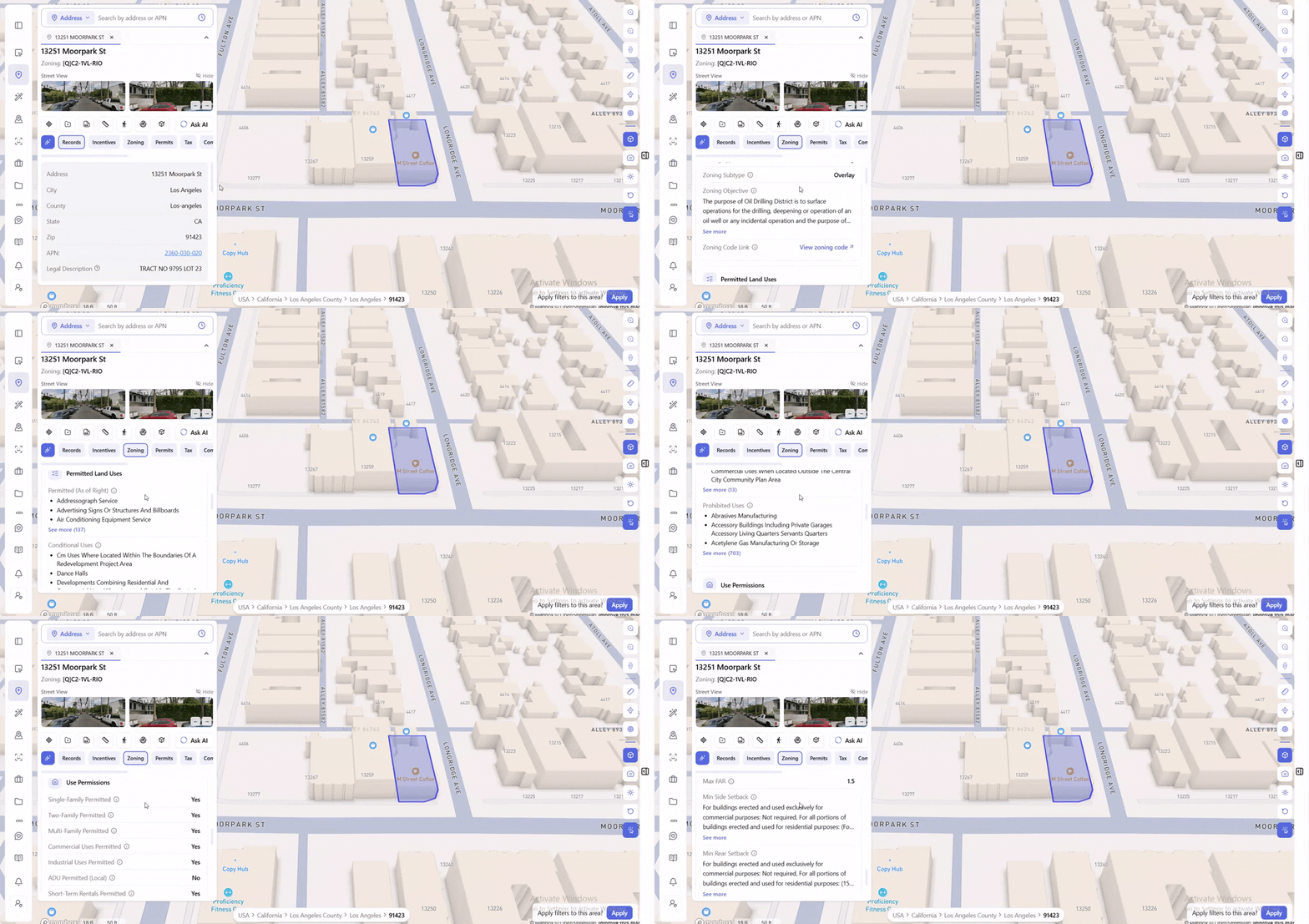
Once Use Permissions confirms “yes,” Dimensional Standards answers how much. On this parcel, Min Lot Area runs 5,000 sq ft for residential portions, Min Rear Setback isn’t required for commercial-only buildings, and Min Landscaped Space is 75% – enough to sketch the outer edge of what’s buildable before spending more time on the parcel.
Neither block replaces the full code. The Zoning tab still splits permitted uses into as of right, conditional, and prohibited – on this parcel, 137 as-of-right uses and 13 more conditional ones, including developments combining residential and commercial outside the Central City Community Plan Area. “Multifamily permitted: yes” doesn’t say whether it’s outright or conditional, and that distinction determines whether a project needs a discretionary review.
One Assistant, Every Multifamily and Mixed-Use Question
Every layer and tab above is something a developer can toggle by hand. ArchiWise AI handles the question a toggle can’t answer directly.
Asked about that same Moorpark St parcel – “Is multifamily permitted by right on this parcel, and does it qualify for a state density bonus?” – ArchiWise AI returned a cited answer in just over 30 seconds, drawing on 25 sources. It confirmed multifamily is by-right under the parcel’s base C2 commercial zoning at R4 density, citing the Los Angeles Municipal Code (LAMC) § 12.14. The 1VL designation caps development at 3 stories and 45 feet (LAMC § 12.21.1); the RIO suffix adds river-overlay requirements; the [Q] prefix requires separate review under LAMC § 12.32.
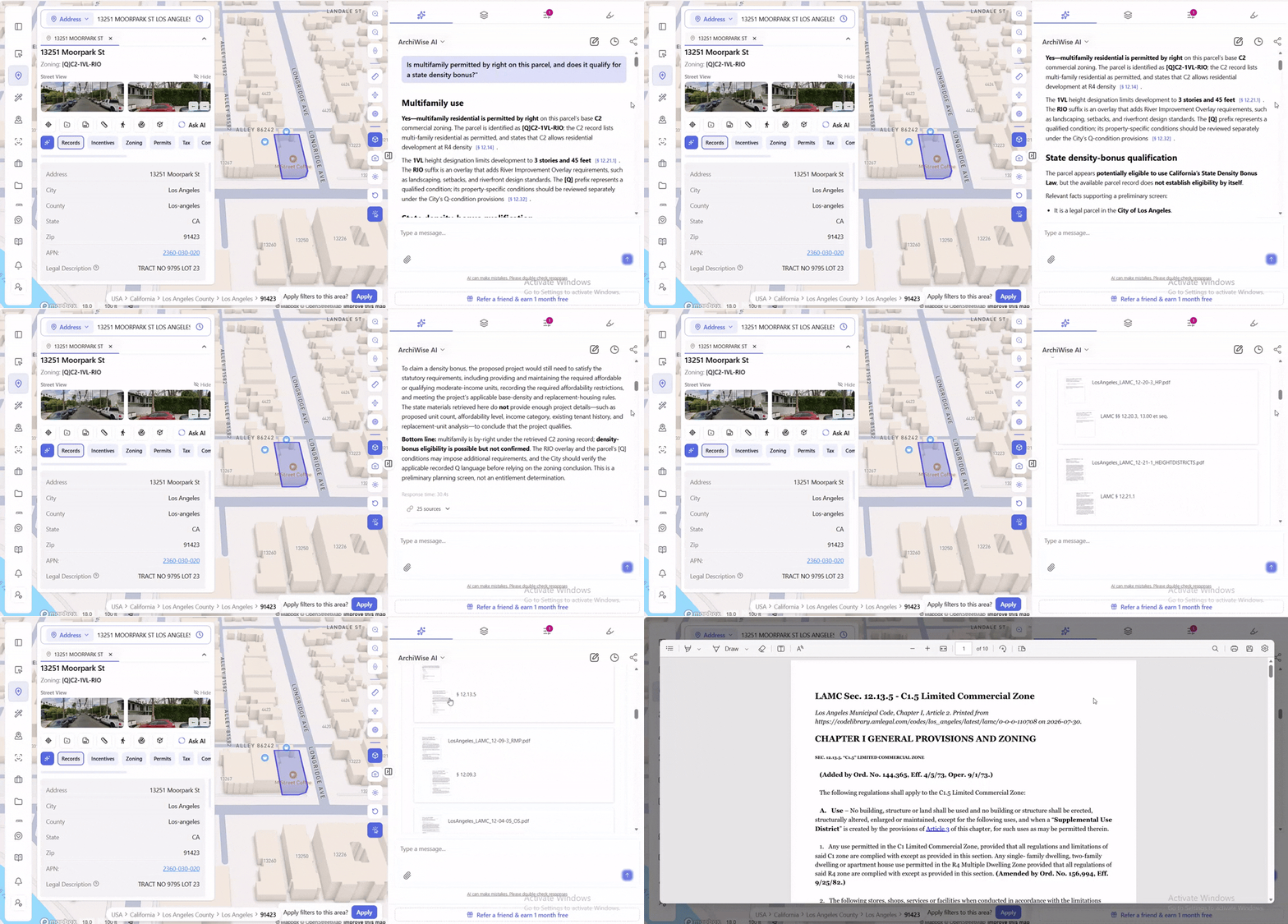
On the density bonus, the answer was more careful – and that’s the useful part. It laid out what supports a preliminary screen (a legal LA parcel, roughly 5,885 sq ft, an existing record showing one recorded unit rather than a multifamily project, no historic designation) and what it couldn’t confirm from the parcel record alone – proposed unit count, affordability level, tenant history. Its conclusion: multifamily is by-right; density-bonus eligibility is possible but not confirmed – “a preliminary planning screen, not an entitlement determination.” That’s the gap a data tab can’t fill on its own: whether a density bonus applies depends on project facts no parcel record contains.
Reading a Submarket Before You Have an Address
Multifamily site selection is still usually address-first: a broker sends a listing, a developer runs the numbers on that one parcel. Area Intelligence flips the order.
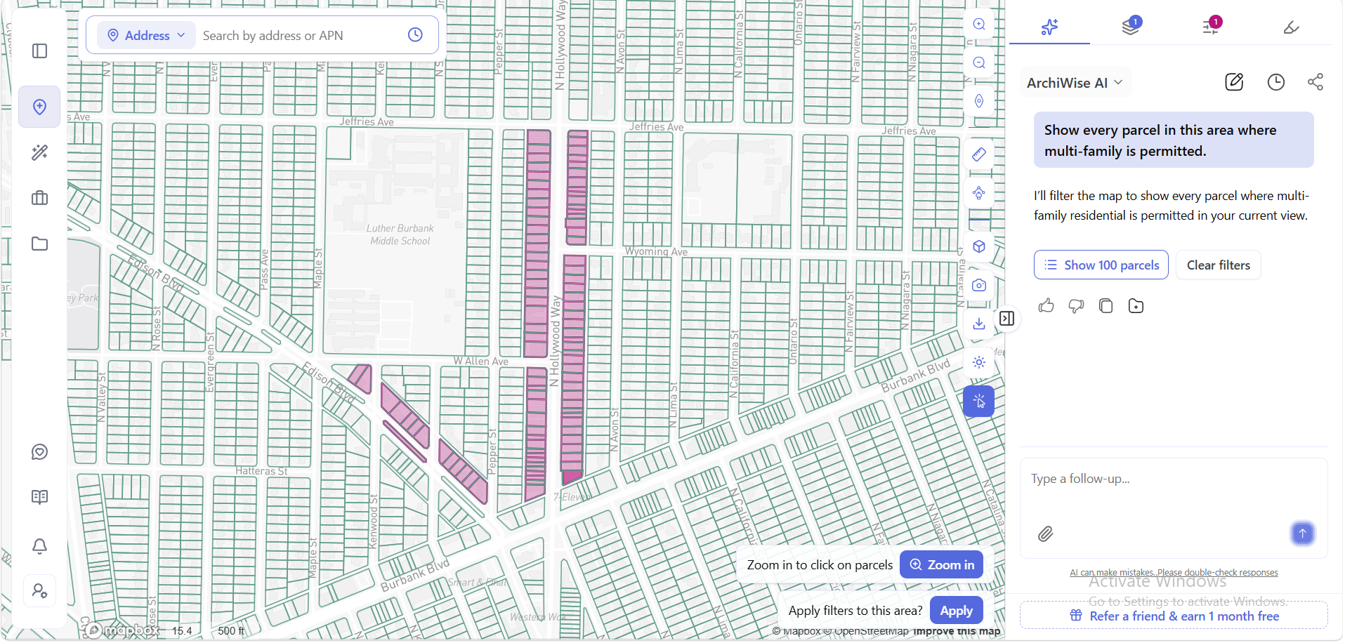
Draw a polygon around a target submarket with Draw Search Area, or filter by map view, zip code, or city. Layer Rent Burden and Homeownership Rate first – that’s the demand signal. Add Hazards to see whether the highest-demand blocks are also the highest-risk. Turn on Housing Incentives to see where QCT or DDA overlap with strong demographics. From there, stack Current Use, Zoning, Ownership, and Proximity in the filter panel, or skip the panel entirely and describe the brief to ArchiWise AI instead. Asking something like “show every parcel in this area where multi-family is permitted” applies the same filter a panel would, just typed rather than clicked – a real search of a Burbank neighborhood returned 100 matching parcels, highlighted directly on the map, with the option to clear filters and try a different area.
This is the actual value of Area Intelligence: it changes which blocks get a second look, not just what a developer learns about a block already under consideration.
What Changes for Mixed-Use Specifically
A mixed-use project asks a different question – not just who lives here, but who walks by, and what would they stop for.
That’s where Points of Interest, Transit Map Stops, and Traffic Volume work together. Toggling all three on over the same corridor shows a cluster of Shop, Leisure, and Office points of interest alongside nearby transit stops, with the road’s own AADT figure a click away – a combined picture no single layer gives on its own. A retail component next to that combination has a fundamentally different customer base than the same footage on a quiet residential block.
The map layers show that picture; the Proximity filter turns it into a screening criterion. Set a reference location – a school, a point of interest, or a specific address – and the filter narrows a drawn area by how parcels sit relative to it. For a mixed-use project, that means anchoring a search to a transit stop or an existing retail cluster rather than scanning for one visually. For multifamily, a school as the reference point is a demand signal in its own right.
On zoning, confirming Commercial Uses Permitted: Yes alongside Multi-Family Permitted: Yes is the fastest first check for a mixed-use parcel, and the full permitted-uses table settles whether the specific retail use in mind is as-of-right, conditional, or prohibited. Finding that out after signing a retail lease is an expensive way to learn it.
Where Area Intelligence Stops
Area Intelligence answers the market question, not every question. A formal market or absorption study is still worth commissioning where ground-floor commercial is more than an amenity. And as the Moorpark St screen shows, ArchiWise AI itself draws a line between what a parcel record confirms and what needs project-specific facts – a preliminary screen, not an entitlement determination.
Coverage is worth being precise about too. Map layers and parcel data are nationwide. ArchiWise AI’s grounded interpretation of local zoning code expands jurisdiction by jurisdiction. A couple of layers are single-market by design – Frontage for Seattle, Sewer Lines for Los Angeles – and Traffic Volume’s coverage is worth confirming directly in the platform before relying on it in an unverified market.
Frequently Asked Questions
What is Area Intelligence in ArchiWise?
The solution that layers hazard, infrastructure, housing incentive, and demographic data over an entire market on the map, rather than requiring a known address to check one parcel at a time.
How do I quickly check if a parcel allows multifamily or mixed-use?
Use Permissions gives a fast yes/no the moment a parcel is clicked. Dimensional Standards adds the next layer – lot area, setbacks, landscaped space – to gauge roughly how much can be built.
Can I ask ArchiWise AI questions specific to multifamily or mixed-use?
Yes – by-right density, permitted ground-floor uses, density bonus eligibility, and area-wide filtering all in one conversation, every answer cited to source and clear about what it can and can’t confirm from the parcel record.
Can Area Intelligence help find sites without a known address?
Yes. Draw Search Area, viewport filtration, and zip or city filtration all work without one, and the filter panel – or a plain-language request to ArchiWise AI – can isolate parcels that permit multi-family across an entire drawn area.
The Bottom Line
Zoning tells a developer what’s legally allowed. Area Intelligence tells them where it’s actually worth checking – and for multifamily and mixed-use, the two questions that matter most are the same two: does the market support it, and does the parcel permit it. Getting a fast answer to both, before a single address comes from a broker, changes how many sites get evaluated and how early the good ones get found.
See the market before you see the address.