

You need the APN, the lot dimensions, and the year built. You need them today, because the seller wants an answer by Friday and you’re not going to make an offer on a parcel whose actual dimensions you’ve never verified.
So you start looking. The county assessor’s portal is free and often has what you need – if you can find it, if the site is up, and if you already know which county you’re searching. Some are excellent. Some look like they were built in 2003 and haven’t been touched since. Title companies will pull a full report, but that’s days and a fee, and it’s overkill when you’re still deciding whether the parcel is worth pursuing at all.
Then multiply that by twelve parcels, across three counties, on a Wednesday.
Who Actually Needs This
Developers screening sites need lot geometry before they can sketch anything. Lot width and depth determine whether a footprint fits. Existing coverage tells them what they’re working around.
Investors want the year built, the current use, and whether the parcel sits in an incentive zone – fast enough to check twenty properties without losing a day to portal navigation.
Architects need parcel boundaries, elevation, and context before the first massing study.
Brokers need the APN (Assessor’s Parcel Number) and legal description to write anything up accurately.
All four are asking the same question at different depths: what is this parcel, actually? And all four hit the same wall. The data is public. It’s just scattered across county systems that were never designed to be searched quickly.
What a Records Search Should Return
That’s the gap ArchiWise was built to close. It’s a pre-development site analysis platform covering every parcel in the US, and every parcel opens into a modal with nine data tabs – Records, Incentives, Zoning, Permits, Tax, Comps, Hazards, Ownership, and Demographics.
Records is the first one. It’s the “what is this parcel, actually” tab – identity, lot geometry, structures, terrain, and the provenance of the data itself, in one scroll. No county selection, no portal login, no guessing which system holds what.
Here’s a real one. 385 E Colorado Blvd, Pasadena, CA – typed into the address bar, one result, parcel highlighted on the map.
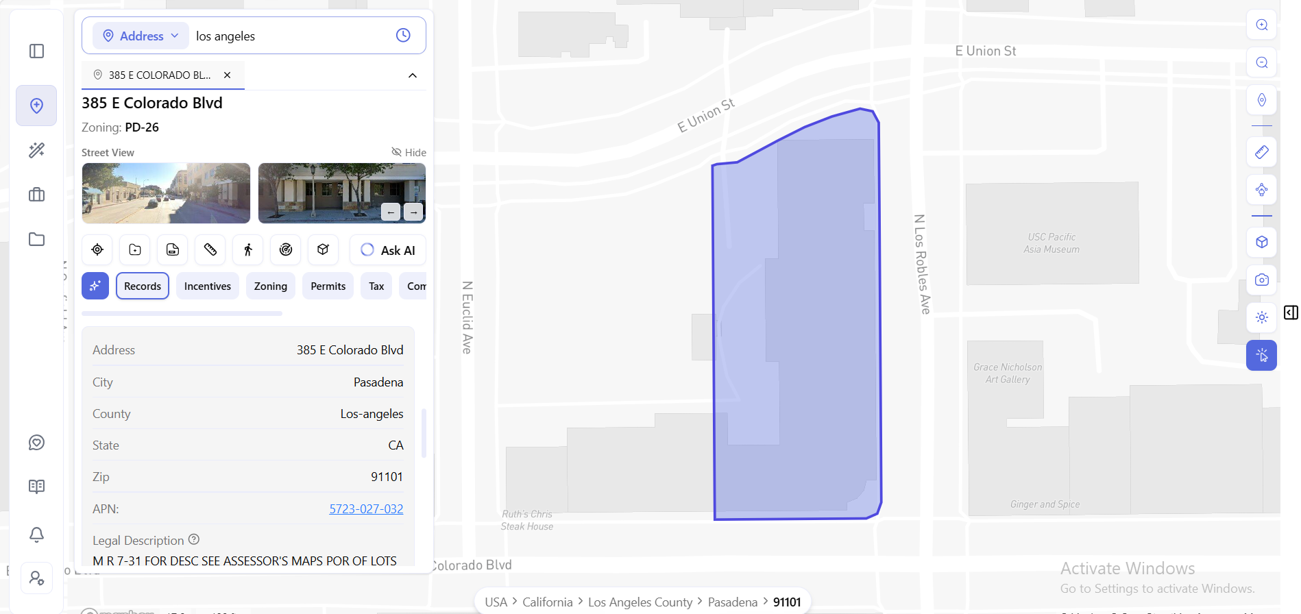
The identity block is what you’d expect from an assessor’s record: APN 5723-027-032, legal description, city, county, zip. Standard, and standard is fine – that’s the part you’d have found eventually. The APN even links straight to the county assessor’s map, so the record points back to its source.
The rest is where it gets interesting.
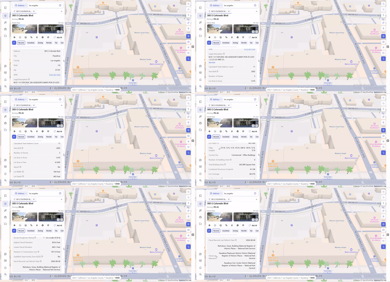
Year Built: 2003. Number of Stories: 5. Current Use: Commercial – Office Buildings. Lot Area: 1.419 acres, or 61,805 square feet. Not vacant.
Then the geometry a flat assessor record usually won’t give you. Lot Width: 164 feet. Lot Depth: 403 feet. And Edge Lengths: 373 ft, 13 ft, 13 ft, 155 ft, 348 ft, 149 ft, 12 ft, 12 ft – eight sides, four of them under fifteen feet. This isn’t a rectangle. It’s a notched, irregular lot, and those short edges are exactly the kind of thing that changes what fits on it.
Total Building Area: 262,988 square feet across a 41,146 footprint, at 66.57% lot coverage, in 1 building.
Then the terrain. Terrain Roughness Rating: 1, on a scale of 0 to 6. Highest elevation 855.6 feet, lowest 845.1 feet – about a 10-foot spread across the parcel. Distance to Transmission Line: 7,671.9 feet. Qualified Opportunity Zone (QOZ): No.
And then the field that would ruin a schedule if you found it late:
Historical Relevance. Three entries, all National Register of Historic Places listings from the National Park Service – the Grace Nicholson Building, the Pasadena Playhouse Historic District, and the Pasadena Civic Center District.
That’s not lot data. That’s a constraint on what you can do here, surfaced on the same screen as the lot dimensions. You’d normally find it after a consultant flagged it, or after a review board did.
None of this is in a typical assessor record. You’d get elevation from a topographic survey, transmission line distance from a utility map, QOZ status from a separate federal lookup, and historic designations from a preservation review. Here it’s one scroll.
The Field Nobody Else Shows You
Parcel Records Last Refresh Date: 2026-08-04.
That one line answers the question underneath every property records search: how old is this?
County portals rarely tell you. Aggregator sites almost never do. You find a lot size, you use it, and you have no idea whether it was updated last week or in 2019.
It’s a small field. It’s also the difference between data you can act on and data you have to go verify somewhere else.
Or Just Ask
Reading the tab is fast. Sometimes asking is faster.
ArchiWise AI sits in the same view as the parcel and answers from that parcel’s actual record, grounded in the city’s own planning documents.
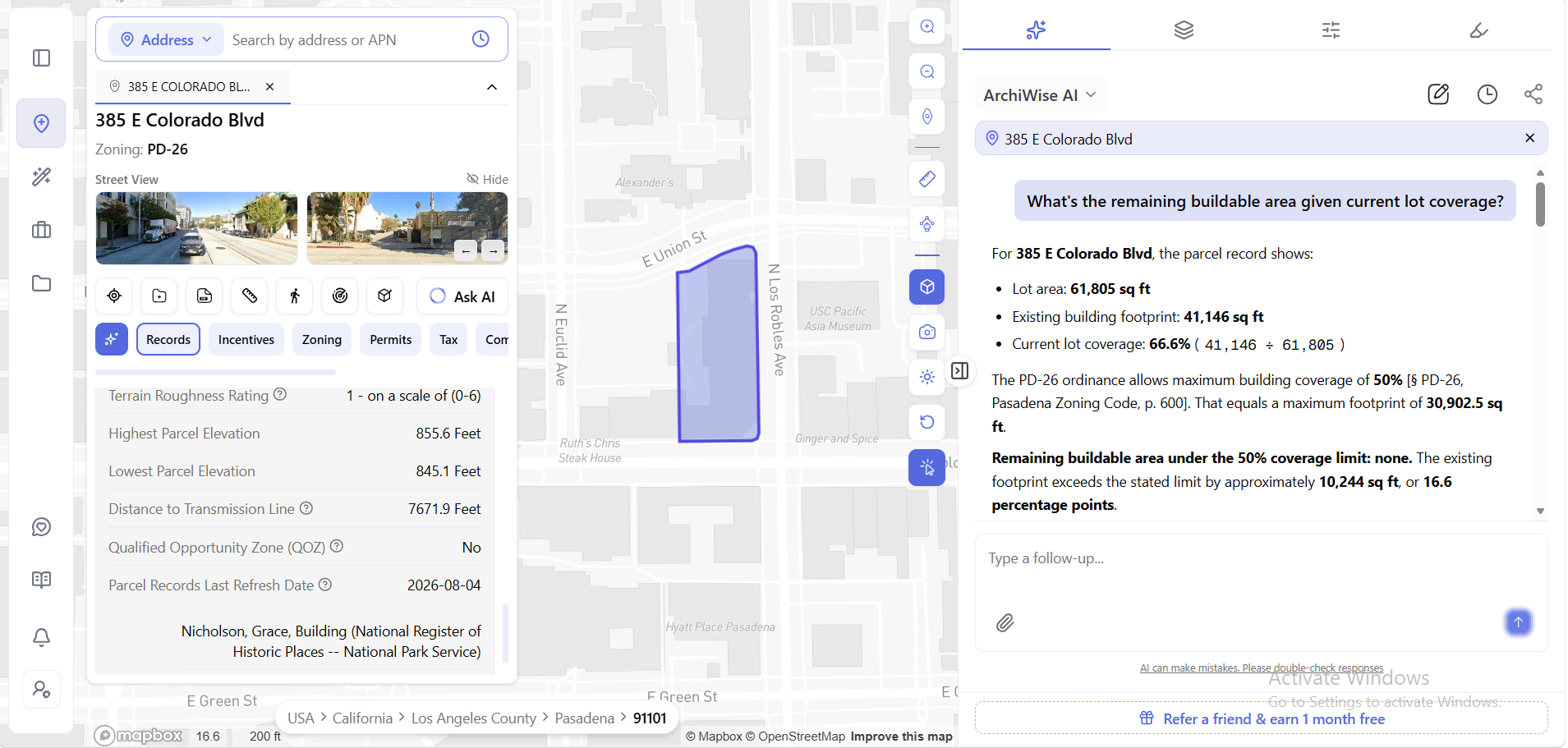
Ask “What’s the remaining buildable area given current lot coverage?” and it pulls lot area (61,805 sq ft) and existing building footprint (41,146 sq ft) straight from the record, works the coverage to 66.6%, and shows the division it used.
Then it goes to the code. The PD-26 ordinance caps building coverage at 50% – cited to § PD-26, Pasadena Zoning Code, p. 600. That’s a maximum footprint of 30,902.5 sq ft.
Remaining buildable area: none. The existing footprint exceeds the limit by roughly 10,244 sq ft, or 16.6 percentage points.
That’s a legally nonconforming condition, surfaced in one question – with a page-number citation you can go verify in the actual zoning code.
Address, APN, Owner Name, or Just Click
The search bar has three modes. Address or APN is the default – type a street address, or paste a parcel number straight from a title document. Same field, either input.
That matters more than it sounds. Addresses are messy – unit numbers, abbreviations, parcels with no address at all. The APN is the stable key, so being able to use either means you’re not reformatting a spreadsheet before you can look anything up.
Switch to Owner name and the search runs the other direction: instead of finding the owner of a parcel, you find every parcel tied to an owner on record.
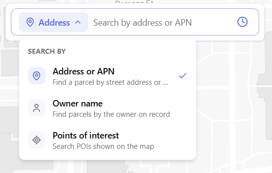
Points of interest is the third mode, for searching POIs shown on the map rather than parcels.
And if you don’t have any of those – if you’re just looking at an area – click any parcel on the map. The same modal opens, same nine tabs, same fields.
Four ways in. One record.
Where the Records Actually Lead
Records is one tab of nine. Zoning, Permits, Tax, Comps, Hazards, Ownership, Incentives, and Demographics sit alongside it – so a lookup that starts as “what is this parcel” becomes “what can I build here” without opening anything else.
More usefully, those same records are what the filters query. Lot size, year built, vacancy, current use – the fields you just read on one parcel are the criteria you can screen thousands of parcels against in AI Site Selection. Looking up a known address is the slow way to use parcel records. Filtering by criteria to find addresses you didn’t know about is the fast way.
FAQ
How do I find a property’s APN from just the address?
Type the address into the search bar. The Records tab returns the APN along with the legal description, city, county, and zip.
Can I search by APN instead of address?
Yes. The Address or APN mode accepts either – type a street address or paste the parcel number directly.
Can I search by owner name?
Yes. Switch the search dropdown to Owner name to find parcels by the owner on record.
How current is the parcel data?
Every parcel record includes a Parcel Records Last Refresh Date so you can see when that specific record was last updated.
What lot measurements are included?
Lot Area in acres and square feet, Lot Width, Lot Depth, Edge Lengths for each side of the parcel, Lot Coverage percentage, Total Building Area, Combined Structures Footprint, and Building Count.
Does it cover parcels outside my state?
Yes – parcel records are nationwide, covering every parcel in the US.
Stop opening county portals. Start with the parcel.