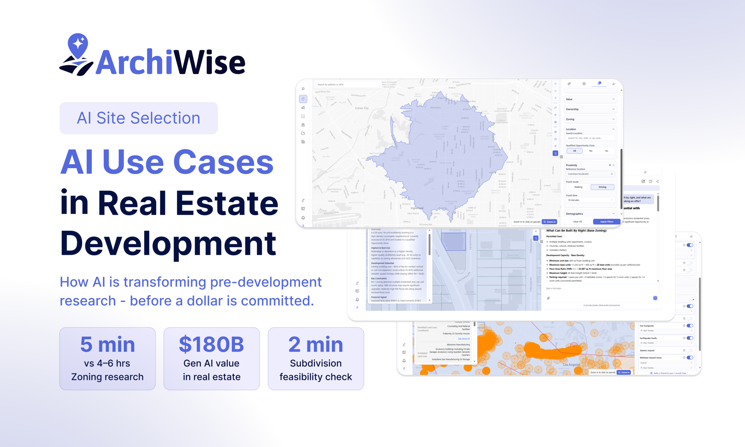
AI Use Cases in Real Estate Development and Land Subdivision
How artificial intelligence is changing the way developers evaluate, analyze, and decide on sites – before a dollar is committed.
Why Real Estate Development Is Uniquely Suited for AI
Real estate development is, at its core, a research problem.
Before a single permit is filed, before a contractor is hired, before financing is secured – a developer needs to answer dozens of questions about a site. What can legally be built here? Is the zoning right? What are the hazards? Who owns adjacent parcels? What’s the market like? Can the lot be split?
Traditionally, answering these questions means hours of manual research – zoning code lookups, county assessor records, planning department calls, environmental database searches, and spreadsheet modeling. For a single site, this pre-development research can take days. For a portfolio of candidate sites, it can take weeks.
That’s starting to change. Artificial intelligence is arriving in real estate development not as hype but as a practical tool for the most information-intensive phase of the business: pre-development research. According to McKinsey Global Institute, generative AI could generate $110 billion to $180 billion or more in value for the real estate industry – and pre-development is one of the highest-impact areas. (Source: “Generative AI can change real estate, but the industry must change to reap the benefits,” McKinsey & Company, November 2023 – McKinsey & Company)
The cost of getting it wrong is enormous. A site that turns out to need a discretionary entitlement, or carries a [Q] condition that caps unit counts, or sits in a flood zone that wasn’t checked, can derail a project that looked viable on paper. AI doesn’t eliminate these risks. But it surfaces them faster, earlier, and more completely than any manual process – before money is committed, not after.
Where AI is making the biggest difference in real estate development right now:
- Site selection and screening – evaluating dozens of candidate sites simultaneously instead of one at a time
- Zoning analysis – reading and applying complex zoning regulations to specific parcels
- Hazard and risk assessment – surfacing seismic, flood, fire, and environmental exposure at the parcel level
- Incentives and feasibility – assembling the financial data inputs that determine whether a project pencils
- Entitlement risk assessment – identifying approval requirements before they become surprises
- Land subdivision feasibility – evaluating whether a parcel can be legally split and what each piece can support
- Market and area intelligence – surfacing demographic and demand data at the neighborhood level
How Purpose-Built AI Differs from General AI in Real Estate
There’s a significant difference between using a general-purpose AI assistant for real estate research and using AI built specifically for real estate pre-development.
A general AI can explain what FAR means. It cannot tell you the FAR for a specific parcel right now. It can describe what a Qualified Census Tract is. It cannot tell you whether your specific site qualifies. It can summarize what a CUP process looks like. It cannot tell you whether your intended use triggers one on this parcel in this jurisdiction today.
Purpose-built real estate AI – connected to live zoning data, parcel records, incentive databases, and planning documents – can do all of these things. The difference isn’t intelligence. It’s data access and specialization.
How Archiwise Changes the Pre-Development Workflow
Before Archiwise, a developer evaluating a single site would spend hours – sometimes a full day – pulling together the information needed to make a go/no-go decision. Zoning lookup. Cross-referencing development standards. Checking the county assessor for value and ownership. Searching FEMA maps for flood zone status. Looking up Census data for demographics. Calling the planning department to confirm whether a use is conditional or by-right.
Each step is manual. Each introduces the risk of something being missed. And by the time the research is done, a faster competitor may have already made an offer.
Archiwise compresses all of this into one session. The moment you click any parcel, the platform surfaces the full zoning picture, development standards, incentive eligibility, hazard exposure, value and ownership data, and neighborhood intelligence – simultaneously, for any parcel in the US.al plans, community plans, state legislation, and local guidelines across cities and counties throughout the US – provides a parcel-specific answer with the applicable source cited.
The result is not just faster research. It’s a different kind of decision-making – one where developers go into negotiations knowing exactly what a site can support, what it will cost to entitle, and whether the market will absorb what they build.
Site Selection and Screening
And for any question the data doesn’t immediately answer, the AI Zoning Expert – trained on thousands of planning documents including zoning codes, specific plans, general plans. Most developers evaluate sites the same way: one at a time, manually, looking at the same MLS and broker listings as every competitor. The problem: listed properties represent less than 5% of viable development opportunities. The best sites are the ones that haven’t hit the market yet.
Archiwise analyzes every parcel in a market – listed or not – based on development potential. Developers draw a custom search area on the map and apply filters across every dimension that matters: lot size, year built, current use, vacancy, land value, improvement value, ownership type, zoning, and demographics.
But what separates Archiwise from basic filter tools is what happens beyond the sliders.
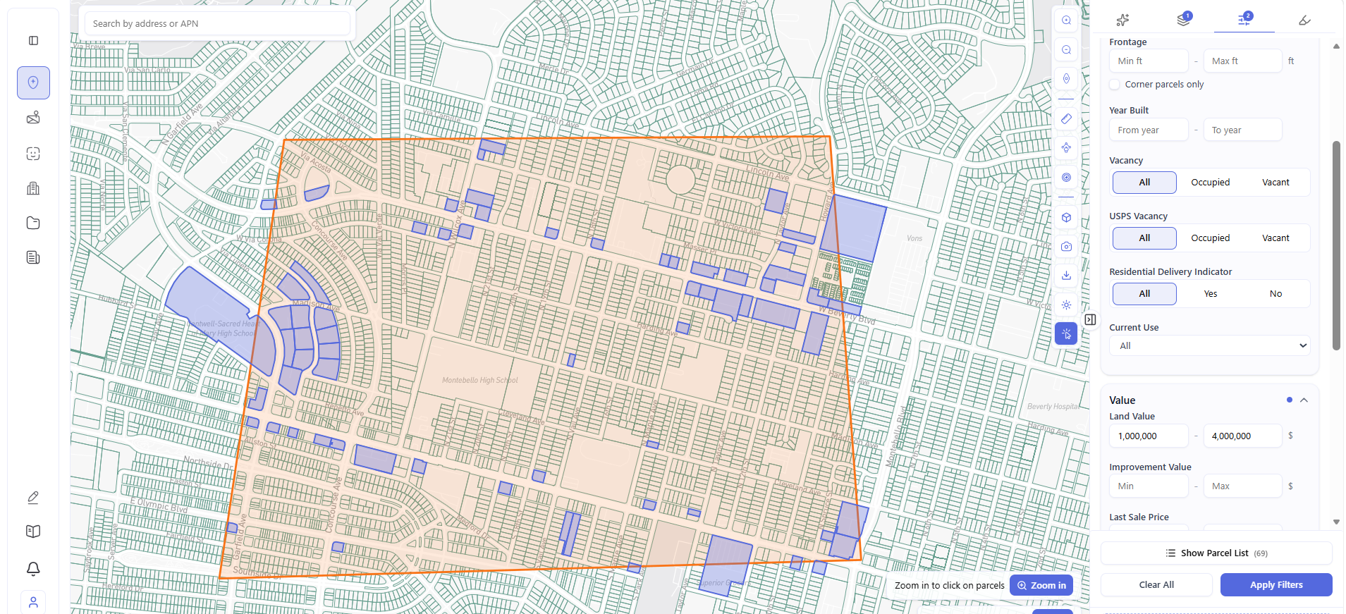
That’s the draw area and filter workflow. But the real power is in proximity intelligence.
Instead of drawing a simple radius circle around a point, Archiwise generates a true isochrone – the actual area reachable within a defined travel time, following real road networks. Set a reference location – a transit station, a school, a major retail anchor, any address – choose walking or driving, set the travel time, and Archiwise instantly maps every parcel reachable within that window.
Here’s the same concept shown with two different Los Angeles reference points – one for walkability, one for drive-time access:
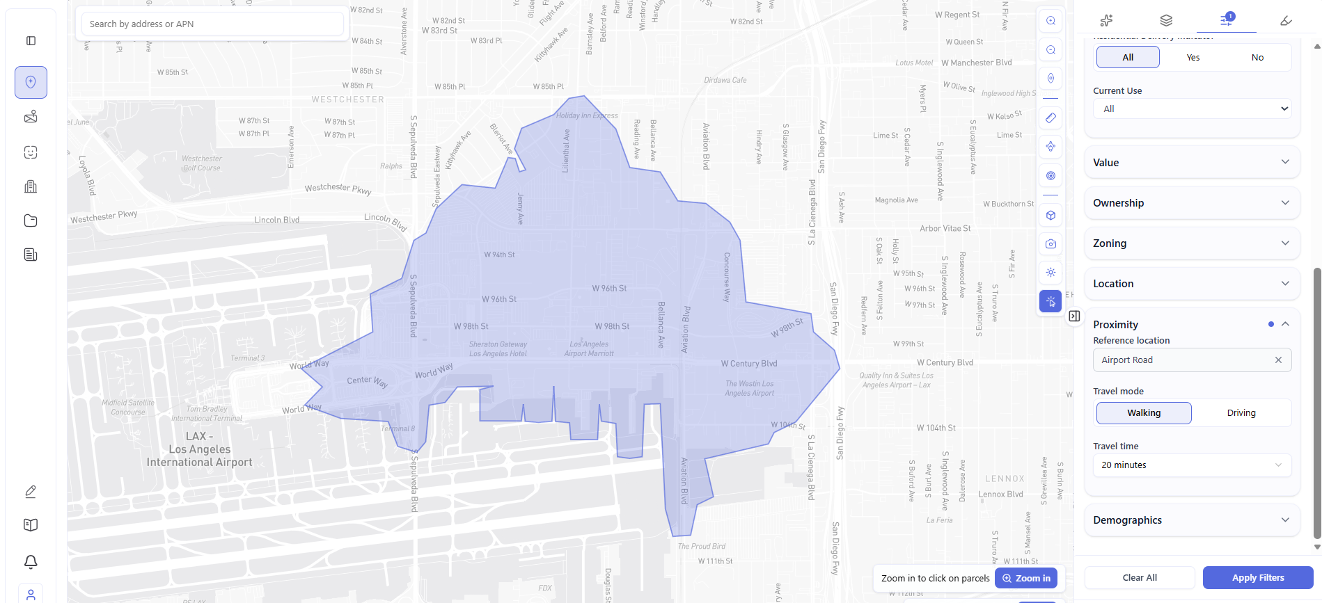
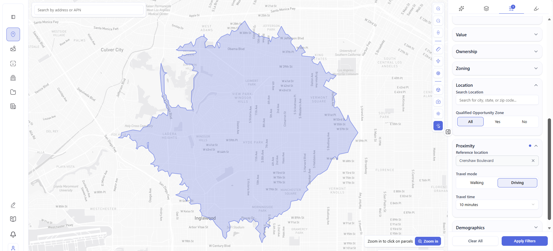 Same city. Two completely different parameters. Two completely different results. A 20-minute walk from Airport Road captures the tight pedestrian-accessible neighborhood around LAX – workforce housing candidates for airport and hospitality employees. A 10-minute drive from Crenshaw Boulevard maps a much larger market – a developer targeting the Crenshaw corridor instantly sees every parcel within reach of one of LA’s most active transit and development corridors. This is the difference between a radius circle and actual accessibility intelligence – and for a developer whose thesis depends on walkability, transit proximity, or drive-time to a specific demand driver, that distinction determines which sites make the shortlist and which don’t.
Off-market sourcing – because Archiwise analyzes all parcels, not just listed ones, developers can identify underutilized sites and contact owners directly. Zero competition. No broker fees. No bidding wars.
Natural language search – instead of adjusting sliders and dropdowns, simply describe what you’re looking for and the platform interprets the request and returns matching parcels instantly.
A lot built in 1955, assessed land value of $800,000, improvement value of $50,000, within a 10-minute drive of a major demand driver: that’s a redevelopment candidate. Archiwise finds it before a broker calls.
Time saved: Site prospecting that previously took days of manual county record searches now takes minutes – across listed and unlisted inventory simultaneously.
Zoning Analysis, Code Interpretation, and Hazard Assessment
Zoning is where the most expensive mistakes in real estate happen -and where AI delivers some of its most immediate value.
Every parcel sits in a zone with its own rules: permitted uses, prohibited uses, FAR limits, height limits, setbacks, parking requirements, overlay conditions. Reading and interpreting those rules for a single site takes hours. For ten candidate sites, it takes days.
But zoning is only half the picture. A site’s physical risks are equally important. Seismic exposure, flood zone designation, fault line proximity, fire hazard, methane zones – these affect construction costs, insurance, financing eligibility, and in some cases whether a project is buildable at all. Most developers don’t find out about hazard exposure until they’re under contract and paying for environmental studies.
Archiwise surfaces both – zoning and hazards – for any parcel, simultaneously, before any commitment is made.
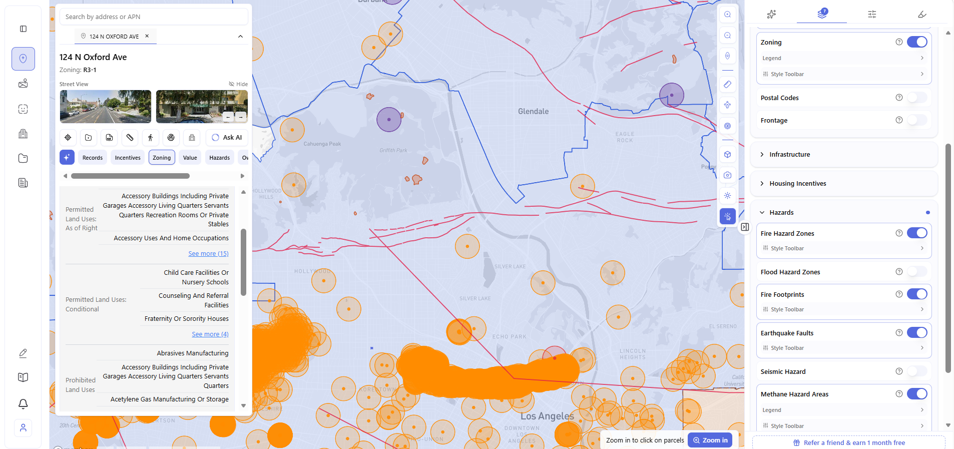
In one view: the full permitted use breakdown for the parcel, and the complete hazard picture for the site and surrounding area. Information that would otherwise require separate searches across zoning codes, USGS, FEMA, and local environmental databases – surfaced in seconds.
Time saved: Zoning and hazard research that previously required 4–6 hours of manual work across multiple databases now takes under 5 minutes.
Icentives and Feasibility Analysis
The difference between a financially viable affordable housing project and one that doesn’t pencil often comes down to one question: does this site qualify for incentive programs?
A Qualified Census Tract designation unlocks a 30% boost on Low Income Housing Tax Credits. A TOC Tier 4 designation eliminates parking requirements and allows up to 80% density increase. A nearby LIHTC precedent confirms the financing pathway has been successfully navigated in this exact neighborhood. Missing any of these is leaving real money on the table.
Real example: A developer evaluating 943 S Normandie Ave in Los Angeles (R4-1, 4,135 sq ft lot) opens Archiwise’s Incentives tab. Instantly visible: the parcel sits in Census Tract 2123.05 – a confirmed QCT – unlocking a 30% LIHTC basis boost worth approximately $270,000 on a $2M project. IROLO APTS – a 32-unit, 100% affordable development – sits just 222 ft away, confirming the financing pathway works in this exact neighborhood.
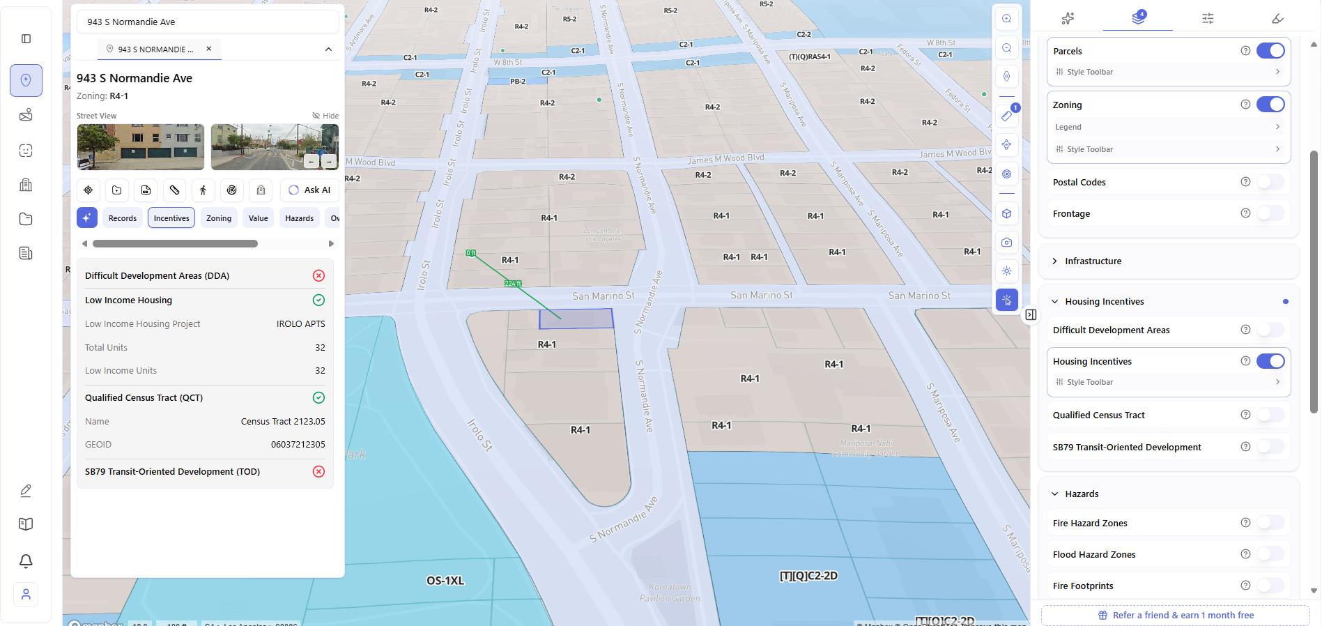
The DDA and SB79 results are equally valuable – they tell the developer exactly which programs don’t apply, so no time is wasted pursuing financing pathways that lead nowhere.
Time saved: Incentive screening that previously required separate QCT map lookups, LIHTC database searches, and TOC tier verification – done in one click.
Entitlement Risk Assessment
One of the most expensive mistakes in development is discovering late that a project requires a discretionary entitlement – a CUP, variance, or rezoning – that adds months or years to the timeline and introduces approval risk. This discovery often happens after design is complete and contracts are signed.
AI identifies the entitlement path for any intended use on any specific parcel before any commitment is made – flagging whether the use is by-right, conditional, or prohibited, and surfacing the specific approval process required.
Consider a developer looking at a commercial parcel zoned [Q]C4-1XL-CDO – a Qualified condition and Community Design Overlay stacked on top of a commercial base zone. They intend to develop multifamily residential. Archiwise’s Zoning tab immediately surfaces the issue: multifamily residential is not permitted by right; a rezoning would be required; overlay conditions impose additional design review requirements. The developer knows the entitlement risk before making an offer – not after paying a planning consultant to find out.
Time saved: Entitlement risk assessment that previously required a planning consultant now happens at the evaluation stage – before any money is spent.
Land Subdivision Feasibility
Most developers look at a parcel and see what’s there. The best developers look at a parcel and ask: what if this were two?
Land subdivision is the legal process of dividing one piece of land into two or more separate lots – each with its own address, its own zoning rights, and its own development potential. Done right, it’s one of the highest-return moves in real estate. A 20,000 sq ft lot that can be legally split into two lots doesn’t just double your options – it can dramatically increase the total value of what you’re sitting on.
The catch: most developers never find out whether a site is subdivisible because the traditional process – hiring a planning consultant, calling the city, waiting weeks – isn’t worth it on a site you haven’t bought yet. That’s exactly the problem AI solves.
What makes subdivision feasible or not: After the split, does each resulting lot meet the zone’s minimum lot area? Does it have sufficient minimum lot width? Does each resulting parcel have frontage on a public street? And once split, what can each piece actually support? These are the questions that determine whether the opportunity is real – and Archiwise answers all of them instantly.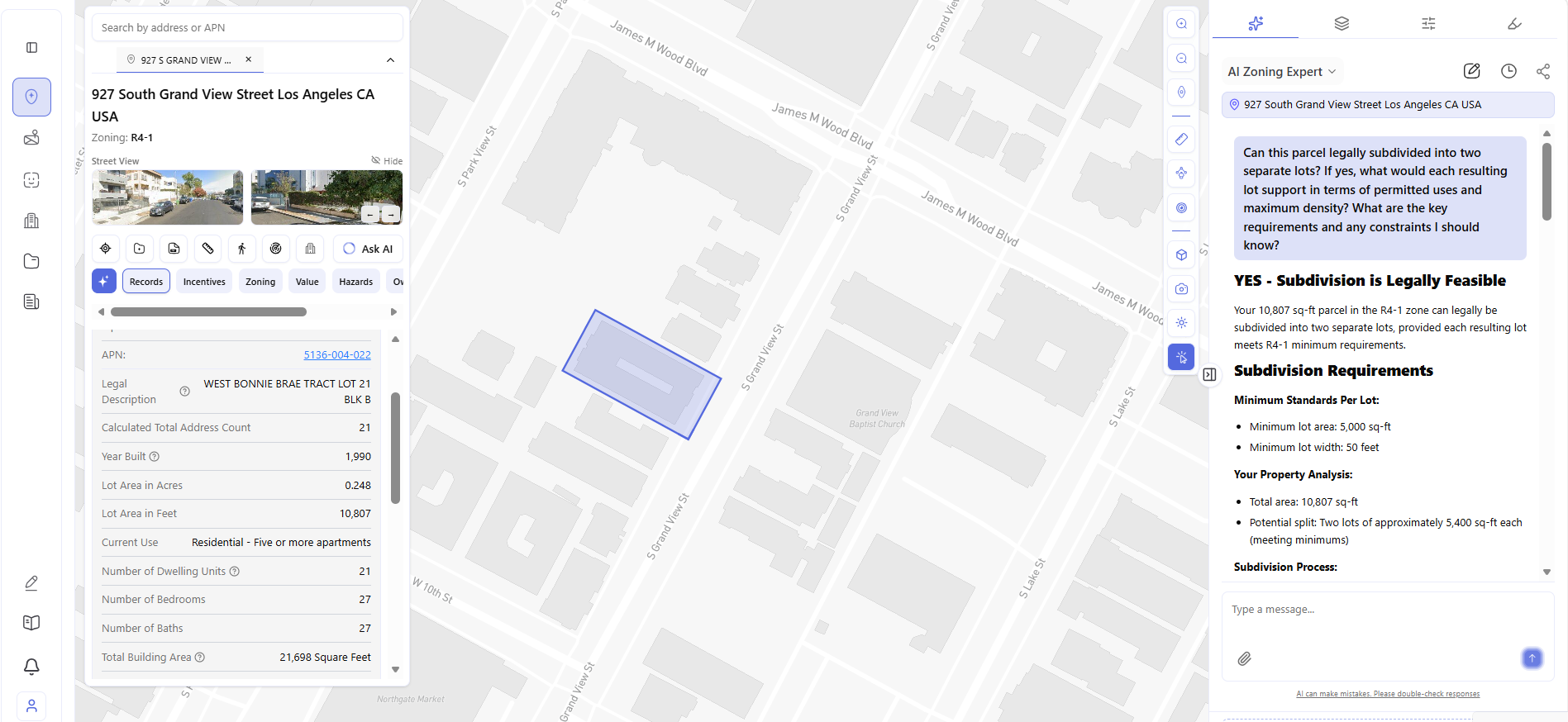
Take 927 S Grand View St in Los Angeles – R4-1 zoning, 10,807 sq ft lot, currently a 21-unit apartment building. The lot area immediately raises a question: could this be split into two separate buildable lots? Instead of calling a planning consultant, the developer asks the Archiwise AI Zoning Expert directly:
The answer comes back in seconds: YES – Subdivision is Legally Feasible. The 10,807 sq ft parcel exceeds the R4-1 minimum of 5,000 sq ft per lot – a split into two lots of approximately 5,400 sq ft each meets the minimum requirements. Before a single call to a planning consultant, before a surveyor is hired, the developer has their go/no-go answer.
Time saved: A subdivision feasibility question that previously required a planning consultant is answered in under 2 minutes – before any professional fees are incurred.
Area Intelligence and Market Analysis
A site doesn’t exist in isolation. The neighborhood around it determines whether a project will fill up, at what rents, and whether affordable housing financing is viable. Gathering this data manually -Census lookups, rent burden calculations, homeownership rate analysis -takes hours and often produces outdated numbers.
Archiwise layers demographic intelligence directly onto the map for any parcel, in real time: population density, renter share, rent burden, median household income, poverty rate -all visible for any site, before any commitment is made.
Consider a high-density residential neighborhood in Los Angeles. The Archiwise Demographics layer surfaces: 55,192 residents at 11,020 per square mile; 89.9% renter share; 37% rent burden -well above the 30% affordability threshold; $49,847 median household income; poverty rate 24.4%. These numbers confirm genuine, persistent demand for affordable housing. Not a trend. A documented reality.
Time saved: Market research that previously required Census data downloads and rent burden calculations is available in one click.
What AI Cannot Replace in Real Estate Development
AI accelerates research. It does not replace judgment.
A developer still needs to know which questions to ask, how to interpret the answers, when a risk is acceptable and when it isn’t, how to negotiate, how to build community relationships, and how to execute a project once it’s approved.
What AI eliminates is the time between having a question and having the information needed to answer it. That gap – historically measured in hours or days – is where bad decisions get made, opportunities get missed, and competitors who move faster win.
The developers who use AI most effectively are not the ones who outsource their thinking to it. They’re the ones who use it to think faster, with better information, earlier in the process.
How Archiwise Applies AI Across the Pre-Development Workflow
Archiwise is purpose-built for real estate pre-development. Every use case in this article is something the platform does today, for any parcel in the US, in seconds.
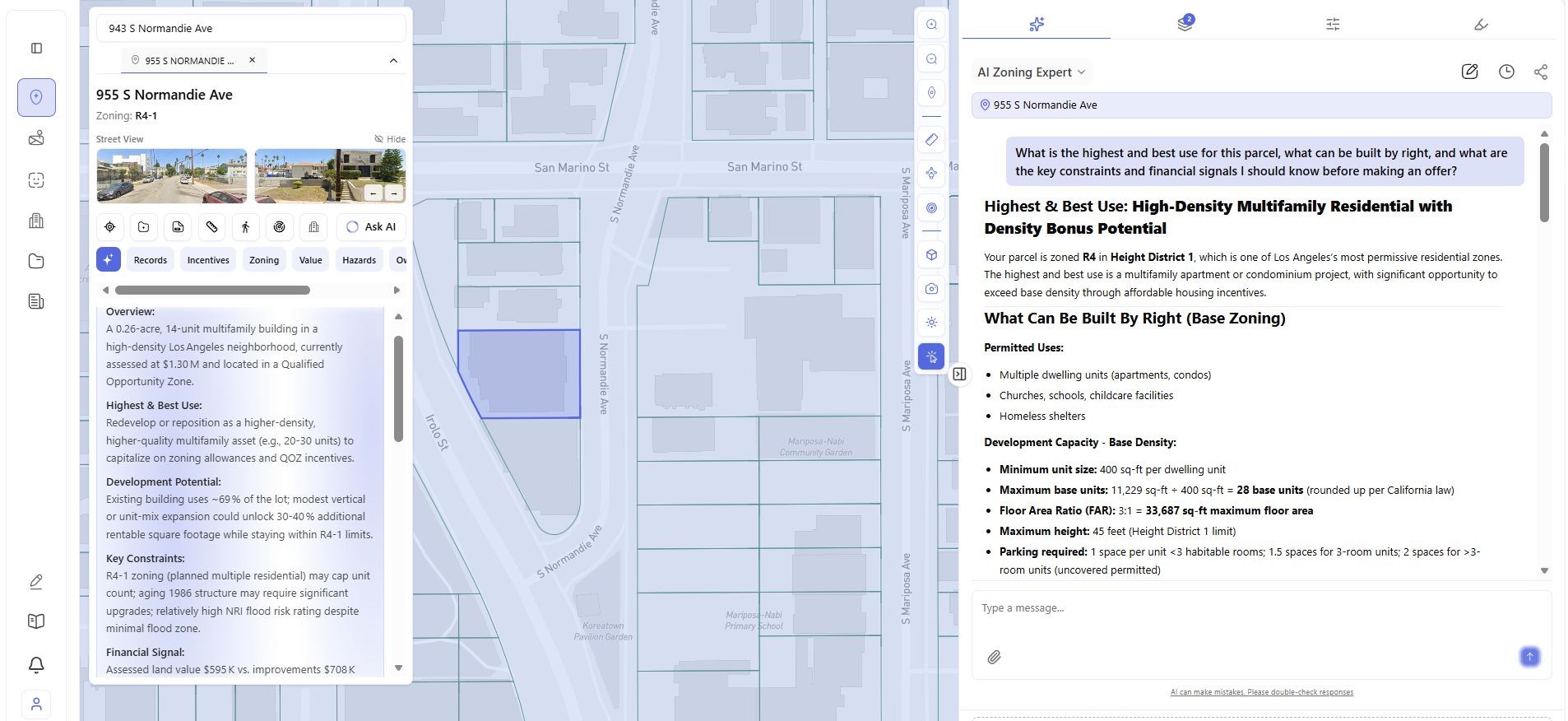
The platform combines live zoning data, an AI knowledge base built from thousands of planning documents – zoning codes, specific plans, general plans, community plans, state senate bills, and local guidelines across cities and counties throughout the US – incentive screening, hazard analysis, value and ownership data, and neighborhood demographics – all in one view, for any parcel, before any money is committed.
And when the data raises a question – or when a developer needs a direct answer before making an offer – the AI Zoning Expert is one click away. Ask anything about the parcel: highest and best use, what can be built by right, what constraints apply, what the financial signals mean. The answer comes back in seconds, drawn from the planning documents that actually govern that specific piece of land.
See Archiwise in action.
Every use case in this article is live in the platform today. Click any parcel. Get the full pre-development picture – zoning, hazards, incentives, value, demographics, and AI-powered answers – in seconds.
Learn more
ArchiWise helps developers, investors, architects, and brokers go from address to decision in minutes, not weeks.
Whether you’re screening sites for multifamily development, evaluating zoning constraints, surfacing incentive eligibility like QCT and LIHTC, or assessing hazard risk before committing capital, ArchiWise runs every layer of analysis in one place.
Explore how ArchiWise helps teams screen development sites, analyze zoning, and make confident go/no-go decisions faster.