

Picture this. You find a site that looks promising. The location is good. The price seems fair. But before you move forward, you need answers. Can you build what you want here? How many units? What are the setbacks? Is there a hidden rule that changes everything?
For most developers, investors, and architects, getting those answers means days – sometimes weeks – of digging through zoning maps, county websites, and PDFs. By the time you have your answer, someone else may already own the site.
This is why AI site screening is changing how real estate professionals choose land. It doesn’t replace the data GIS maps give you. It replaces the slow, manual work of turning that data into a real answer. Platforms like ArchiWise are leading this shift, especially when it comes to site selection.
Let’s look at why this change is happening, and what it means for you.
The Problem With Traditional GIS Workflows
GIS, or Geographic Information Systems, has been the standard tool for site research for a long time. It shows you maps, zoning layers, and property boundaries. That’s useful. But GIS was built to show you where things are. It was never built to tell you what you can do with them.
So the real work still falls on you. You still have to open the zoning code. You still have to find the right section. You still have to figure out what an overlay district means for your project, or whether a density bonus program applies. Zoning codes are long, and they’re written for lawyers, not developers.
This slows everything down. A single site can take days to research fully. And because that research takes so long, most teams can only look closely at a handful of sites at a time. Good deals get missed simply because there wasn’t time to check them.
It also raises the risk of costly mistakes. Miss one overlay rule, and a project that looked solid on paper can fall apart during design.
What Is AI Site Screening?
AI site screening closes this gap. Instead of just showing you zoning data, it reads and interprets that data for you.
Think of it as three levels of tools:
- Maps and GIS layers – show you zoning boundaries, but don’t explain them.
- Zoning data platforms – give you structured facts, like FAR or height limits, but you still have to figure out what they mean for your project.
- AI decision platforms – read the actual zoning code, planning documents, and overlays, then give you a plain-English answer, with the source attached.
That third level is where AI site screening lives. You can ask a simple question, like “Can I build a fourplex here?” and get a real answer in minutes, not days.
Why AI Is Replacing GIS Workflows
A few clear reasons explain why this shift is happening so fast.
Speed. What used to take days now takes minutes. In a market where good sites don’t stay available for long, speed alone can decide who wins a deal.
Accuracy. Zoning codes are dense and easy to misread. A single zone designation can point to dozens of extra rules and overlays. AI tools grounded in real planning documents lower the risk of missing something important.
Wider search. Manual research only lets you review a handful of sites closely. AI tools can screen an entire market at once, including sites that aren’t even listed for sale. That opens the door to opportunities you’d never find by browsing listings alone.
Hidden value. Density bonus programs and local incentive rules are easy to miss by hand, but they can turn a marginal deal into a strong one. AI tools are far better at catching these details, because they check every relevant rule, not just the obvious ones.
This shift matters even more now. According to JLL’s 2025 Global Real Estate Technology Survey, 88% of real estate investors, owners, and landlords have started testing AI tools. But only 5% say they’ve reached their full goals with it, and more than 60% say they’re not fully ready to use AI at scale yet. In short, most of the industry is still catching up. The teams that move early on tools built for site selection are setting themselves apart.
How ArchiWise Replaces the Traditional GIS Workflow
ArchiWise was built to solve exactly this problem: turning zoning and site research from a slow, manual task into a fast, clear decision.
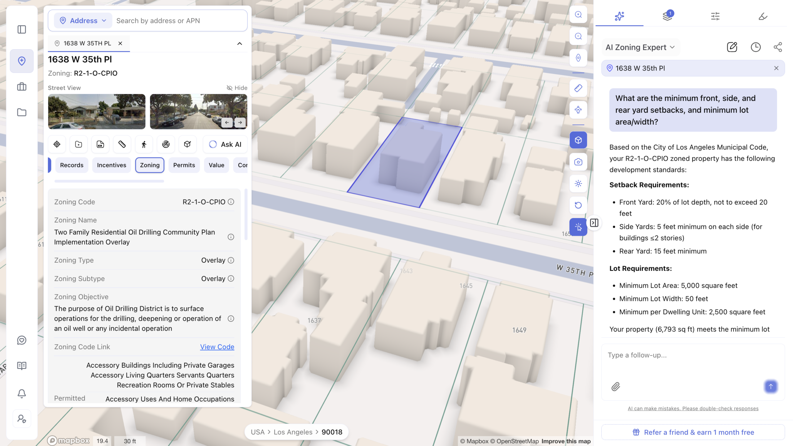
The AI Zoning Expert lets you ask a plain question about any parcel and get a full answer: what you can build, FAR, height limits, setbacks, parking rules, and any overlay zones that apply. Every answer points back to the real planning document it came from, so you can trust it.
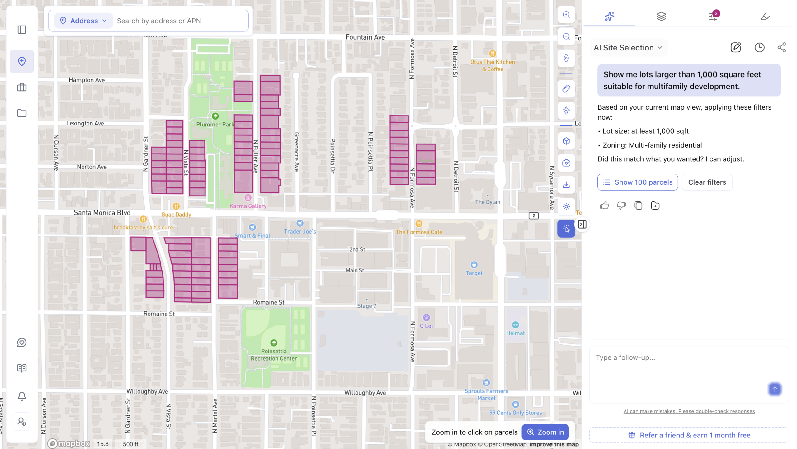
 The AI Site Selection tool goes further. Instead of checking one site at a time, it can search an entire area for parcels that match what you’re looking for – even land that isn’t listed for sale. Since listed properties are only a small slice of what’s actually available, this opens up far more options.
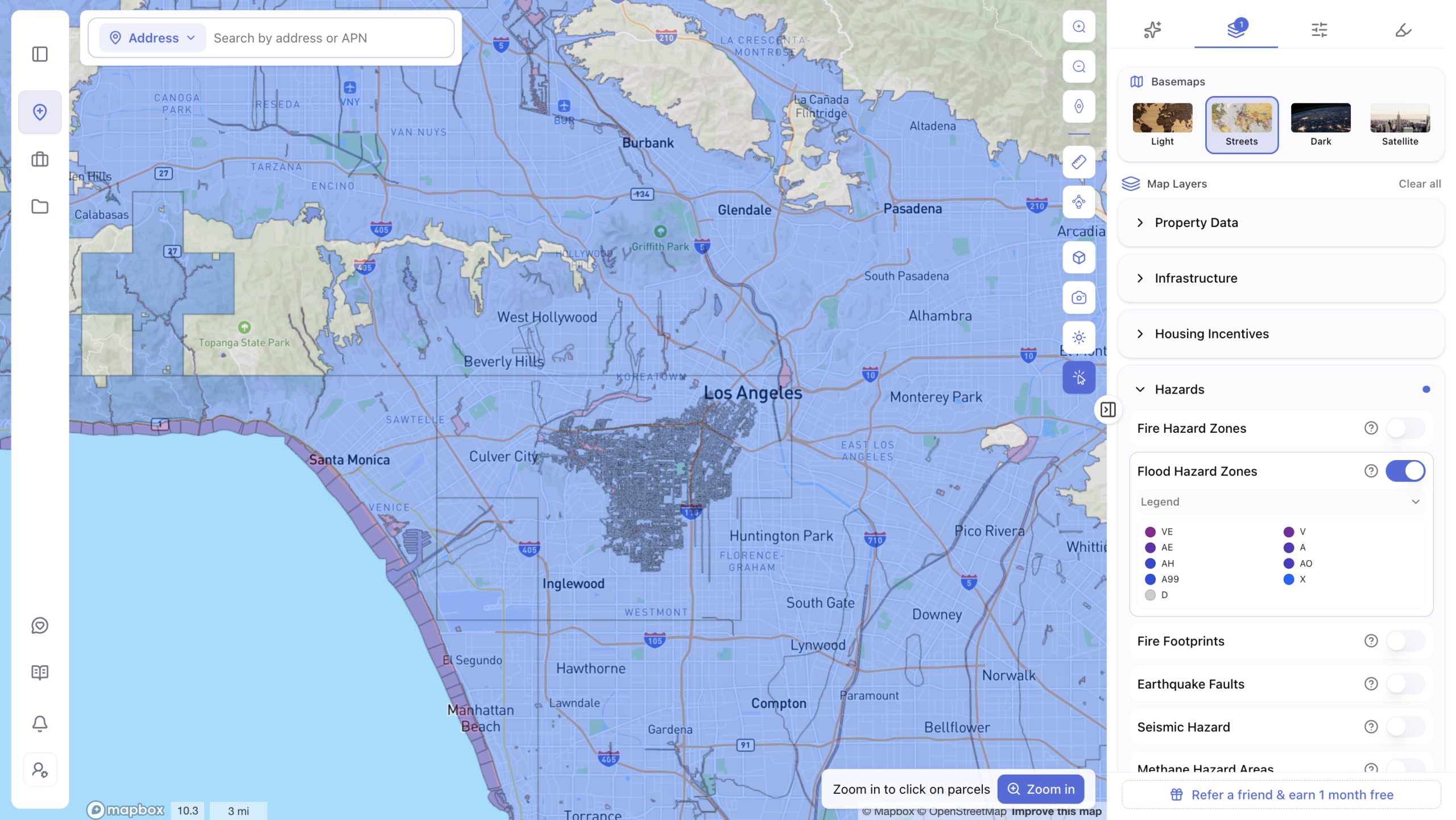
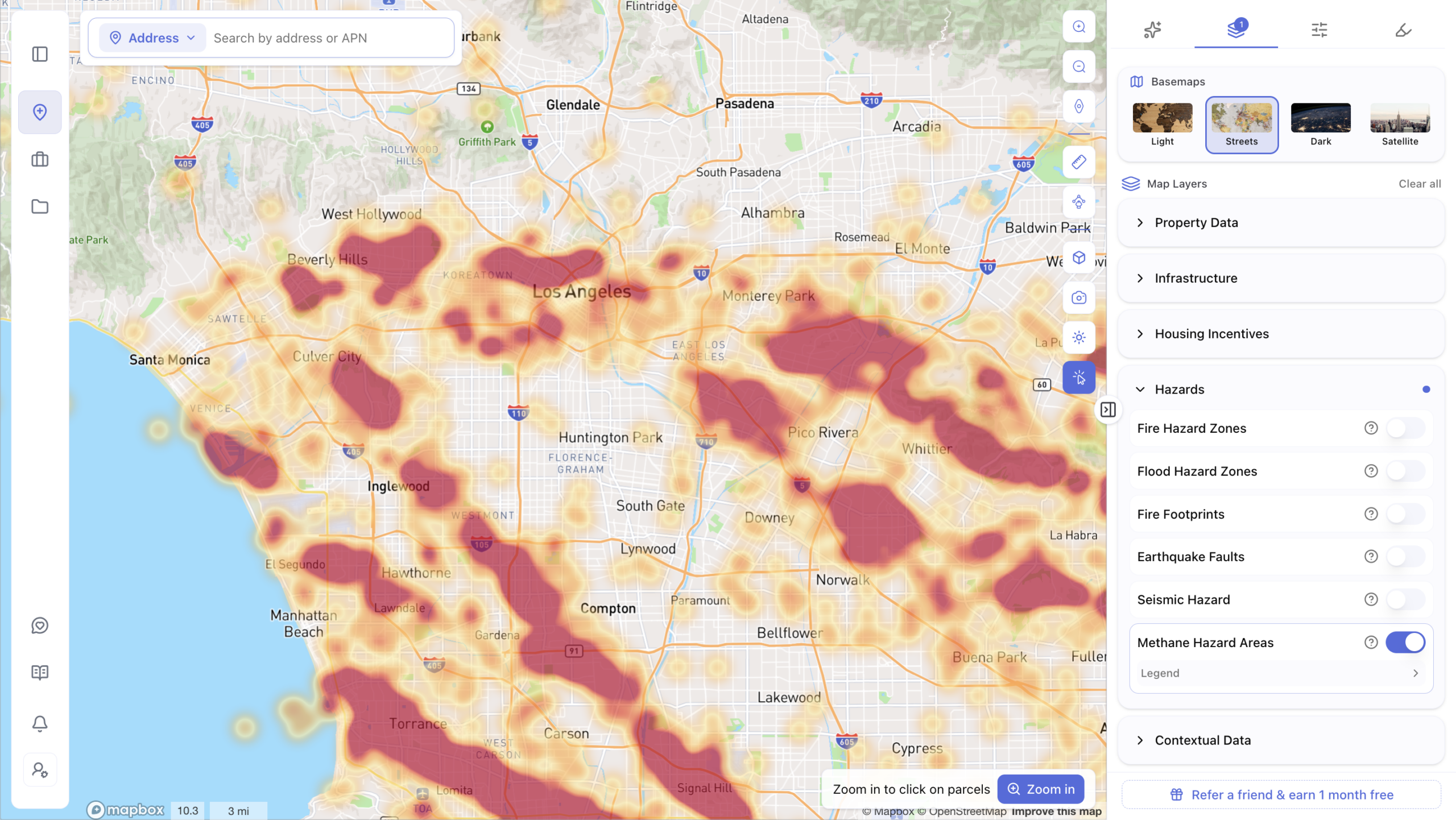
 Hazard and feasibility data are built in too. Zoning approval alone doesn’t mean a site is safe to build on. ArchiWise also flags flood zones, fire risk, and other site issues early, before you spend money on consultants.
This is already changing outcomes for real teams. One development firm used ArchiWise to find a density bonus program that turned a marginal deal into a much stronger one. Another firm caught an overlay restriction that would have cost hundreds of thousands of dollars in redesign, had it gone unnoticed.
How ArchiWise Compares to Other Tools
A few other tools live in this space. Here’s how they differ:
| Tool | What it does | Where it fits |
| Zoneomics | Provides structured zoning data and reports | A data source – you still interpret it |
| TestFit | Turns zoning data into building layouts, unit counts, and yield studies | Feasibility testing, usually while comparing specific sites |
| Symbium | Handles permitting and code compliance, mostly for ADUs and solar | Permitting stage, narrower use cases |
| Prophetic | AI platform for land acquisition, with automatic site plans | Strong for large-scale land teams |
| ArchiWise | Reads zoning, hazards, and parcel data, and gives clear, cited answers | Site selection and pre-development decisions |
Each tool solves a different part of the puzzle. ArchiWise’s focus is the earliest and most important step: knowing if a site works before you commit any money or time to it.
Frequently Asked Questions
What is FAR in real estate? FAR stands for Floor Area Ratio. It compares a building’s total floor space to the size of the lot it sits on. Zoning codes use this ratio to control how much you’re allowed to build.
What is zoning? Zoning is the set of local rules that decide what can be built on a piece of land, and how it can be used.
How long does zoning research usually take? Done manually, it often takes several days to a few weeks per site, depending on how complex the local code is.
What is pre-development? Pre-development is the research stage before design or construction begins. It includes zoning checks, feasibility studies, and site risk review.
How do I check zoning for a specific address? You can search your local zoning map, but it usually takes more than a map to know what you’re actually allowed to build. Tools like ArchiWise give you a full, cited answer in minutes.
The Bottom Line
Traditional GIS workflows were never built to answer the questions developers actually ask. They show you data. They don’t tell you what to do with it. That gap is exactly why AI site screening is taking over – and why the teams using it are finding better sites, faster, with fewer costly surprises.
Stop Losing Deals to Slow Research
Every day spent digging through zoning code is a day your competitor might be closing on the site you wanted. Land is getting harder to find, prices are rising, and the firms still relying on manual research are falling behind. The market doesn’t wait. Neither should you.
Try ArchiWise free today and find out what your next site can really do – in minutes, not weeks. Your competition is already looking. Get there first.
Learn more
ArchiWise helps developers, investors, architects, and brokers go from address to decision in minutes, not weeks.
Whether you’re screening sites for multifamily development, evaluating zoning constraints, surfacing incentive eligibility like QCT and LIHTC, or assessing hazard risk before committing capital, ArchiWise runs every layer of analysis in one place.
Explore how ArchiWise helps teams screen development sites, analyze zoning, and make confident go/no-go decisions faster.