

A plain-language guide for developers, investors, and architects.
What Is Zoning AI?
Zoning AI is software that uses artificial intelligence to read, interpret, and apply zoning regulations to specific parcels of land – answering the questions developers actually need answered before committing to a site.
Not “what zone is this parcel in?” – that’s a lookup. Zoning AI answers: “Given this zone, what can I build here by right, what approvals would I need for my intended use, what are the development constraints, and what incentive programs apply?”
The distinction matters. Zoning data has been publicly available for decades. What’s new is the ability to interpret that data – to take a zoning designation like [Q]RD3-1-CUGU and tell a developer, in plain language, exactly what it means for their specific project.
Why Zoning Research Is Broken Without AI
Pre-development zoning research is one of the most time-consuming and error-prone tasks in real estate. Here’s why.
Zoning codes are written for lawyers, not developers. A single zone designation can reference dozens of subsections, conditional standards, and overlay requirements across hundreds of pages of municipal code. Reading and interpreting it for a specific parcel – accounting for the height district, [Q] conditions, applicable specific plan, and overlay ordinances – takes hours even for experienced professionals.
Every jurisdiction is different. Los Angeles has 34 community plan areas and a zoning code currently in transition between Chapter 1 and Chapter 1A. New York has ULURP. Houston has no zoning at all. Chicago has PD overlays. Each city has its own system, its own terminology, and its own exceptions. A developer working across multiple markets is essentially learning a new regulatory language for every deal.
The cost of getting it wrong is enormous. A project designed for a site where multifamily residential is prohibited – because the zone is C2 and no one checked – can mean months of redesign and entitlement delays discovered after contracts are signed. A missed QCT designation can cost hundreds of thousands of dollars in tax credit financing that was sitting there, unclaimed.
Manual research doesn’t scale. Evaluating ten sites one at a time takes ten times as long as evaluating one. Developers who evaluate more sites, faster, find better deals. Manual research is the bottleneck.
How Zoning AI Actually Works
Zoning AI isn’t one thing. There’s a significant difference between platforms that show zoning as a map layer and platforms that can actually answer questions about a specific parcel.
The first type – map and data platforms – connect to zoning databases and display the designation for any parcel. You see the zone, the overlay conditions, the incentive flags. It’s faster than a manual lookup and covers more jurisdictions. But it still requires you to interpret the data yourself. You see [Q]C4-1XL-CDO and you still have to figure out what that means for your project.
The second type – AI chat platforms with document grounding – go further. These systems are built on a knowledge base of actual planning documents: zoning codes, specific plans, general plans, community plans, state legislation, overlay ordinances, and local guidelines. When you ask a question about a parcel, the AI retrieves the relevant sections from the documents that govern that specific location and reasons through the answer – citing the source.
Here’s what that looks like in practice. A parcel zoned [Q]C2-1L-CDO-RIO in Archiwise surfaces all of this instantly:
- Zoning Name: Qualified Commercial Community Design River Improvement Overlay
- Zoning Objective: Full purpose statement of the CDO district – pulled from the applicable ordinance
- Permitted Land Uses As of Right: 137 uses
- Permitted Land Uses Conditional: 13 uses including Dance Halls, Developments Combining Residential and Commercial Uses
- Prohibited Land Uses: 702 uses
- Single-Family, Two-Family, Multi-Family, Commercial, Industrial: all permitted
- ADU: Not permitted locally
- Max Building Height: 75 ft (6 stories)
- Max FAR: 1.5
- Min Lot Width: 50 ft
- Min Side and Rear Setbacks: Different rules for commercial vs residential use, varying by building height – all spelled out
- Min Landscaped Space: 75%
- Zoning Code Link: Direct link to the applicable zoning code
That’s not a lookup. That’s the full rulebook for that specific parcel – surfaced in seconds, before the developer has spent a dollar. And for any question the data doesn’t immediately answer, the AI Zoning Expert is one click away.
The difference between the two types of zoning AI is the difference between seeing the zone name and understanding what it means for your project.
Manual Research vs. Zoning AI: A Real Parcel, Two Timelines
The parcel: 2038 Hollenbeck Dr, Los Angeles – zoned RD1.5-1-CUGU. A developer wants to know: what can be built here, what are the development constraints, and does this site qualify for any incentive programs?
Manual research – what it actually takes:
- Look up the parcel on ZIMAS – get the zoning designation RD1.5-1-CUGU
- Decode the designation: RD1.5 = Restricted Density Multiple Dwelling, 1 = Height District 1, CUGU = Clean Up Green Up Overlay
- Open the LAMC and find Section 12.09.1 – read the RD1.5 standards for minimum lot area per unit (1,500 sq ft), height limit (45 ft), setbacks, parking requirements
- Find and read the CUGU overlay ordinance to understand what additional restrictions apply
- Cross-reference the Cornfield Arroyo Seco Specific Plan to see if it applies to this parcel
- Check the TOC map separately to determine transit proximity tier
- Look up QCT eligibility on HUD’s mapping tool
- Check the county assessor for land value, improvement value, and ownership
- Pull Census data for neighborhood demographics
For experienced researchers, this takes days. For junior staff, longer. Either way, it’s time that could be spent evaluating the next site – and everyone makes mistakes.
Archiwise – what it actually takes:
Click the parcel. The Zoning tab surfaces: Zoning Code R3-1-O, Zoning Name “Multiple Residential Oil Drilling,” Zoning Type Residential, Zoning Subtype Multi Family, and a direct link to the applicable zoning code. Permitted Land Uses As of Right include Accessory Buildings, Private Garages, Living Quarters, Recreation Rooms, Private Stables, Accessory Uses and Home Occupations, and 16 more. Permitted Land Uses Conditional include Child Care Facilities, Nursery Schools, Counseling and Referral Facilities, and more- all pulled directly from the applicable zoning code for that parcel.
The Incentives tab shows TOC eligibility, QCT status, DDA designation, and nearby LIHTC precedents. The Value tab shows assessed land value, improvement value, and last sale price. The Demographics tab shows renter share, rent burden, and median income.
Ask the AI Zoning Expert: “What is the current zoning designation of this parcel, what can I build here by right, what are the key development constraints including FAR and height limits, and what incentive programs apply to this site?”- and get a full parcel-specific analysis drawn from the applicable zoning code: R3-1-O- Multiple Dwelling Zone with Height District 1 and Oil Drilling Overlay, broken down into its three components (R3 zone, Height District 1, O Overlay), by-right uses, and density calculations specific to the parcel’s 10,693 sq ft lot- 13 maximum base units at 800 sq ft minimum per dwelling unit. Sources cited.

Time: under 5 minutes.
Zoning AI vs. Lookup Tools
ZIMAS, county assessor portals, and municipal GIS tools are lookup tools. They show you data. They don’t interpret it.
The difference isn’t about access to information – most zoning data is publicly available. The difference is what happens after you have it.
A lookup tool tells you a parcel is zoned [Q]C4-1XL-CDO. A zoning AI tells you: the base zone is C4 regional commercial, but the 1XL height district caps the building at 22 ft and FAR at 1.5:1 – dramatically below what C4 would otherwise allow. The [Q] condition imposes ordinance-level restrictions that may cap unit counts. The CDO requires design review. And multifamily residential isn’t permitted by right – a rezoning would be required, adding 1–3 years and significant approval risk.
That’s not more data. That’s interpretation – and interpretation is what drives development decisions.
ZIMAS is genuinely comprehensive – but only for the City of Los Angeles. It shows hazards, incentives, planning case history, state law criteria, and assessor data. The moment a site falls outside LA city limits – Culver City, Long Beach, Santa Monica, or any other jurisdiction – ZIMAS returns nothing. Archiwise covers parcels nationwide, applying the same depth of zoning analysis, incentive screening, and AI interpretation to any city, county, or state in the US.
What Zoning AI Can Do That General AI Cannot
Developers increasingly turn to general AI tools – ChatGPT, Claude, Gemini – for zoning questions. These tools are capable and useful. They’re also fundamentally different from purpose-built zoning AI.
General AI can:
- Explain what FAR means
- Describe how a CUP process typically works
- Summarize a zoning code section you paste in
- Reason through a hypothetical entitlement scenario
General AI cannot:
- Tell you the current zoning designation for a specific address right now
- Tell you whether that parcel qualifies for a TOC density bonus
- Surface the [Q] conditions that apply to a specific parcel
- Tell you what the assessed land value is
- Confirm whether a LIHTC project has been built nearby
The gap is live data and document grounding. A general AI draws on training data. A purpose-built zoning AI retrieves from the actual planning documents governing the specific parcel – in real time, with sources cited.
When someone asks a general AI “what can I build on this site?” the honest answer is: it doesn’t know. It’s never seen the specific plan, the overlay ordinance, or the [Q] conditions for that parcel. It can describe what’s typical for that zone type. It can’t tell you what’s true for that piece of land.
What Can Zoning AI Get Wrong?
Zoning AI is powerful. It’s not perfect. Here’s what to watch for.
Complex stacked conditions can be subtle. When multiple overlays, [Q] conditions, and specific plans all apply simultaneously – as they often do in dense urban markets – the interactions between them require careful reasoning. A well-built zoning AI flags these conflicts and recommends verification.
Planning documents have gaps. Municipal zoning codes are imperfect documents – sometimes contradictory, sometimes ambiguous, sometimes outdated. When the source document is unclear, the AI answer will reflect that uncertainty. This isn’t a flaw in the AI – it’s a characteristic of the regulatory environment.
Codes change. A new overlay ordinance, a general plan amendment, or a state law that preempts local zoning can change what’s permitted on a parcel quickly. The best zoning AI systems update continuously – but no system updates instantaneously.
AI is not a planning consultant. For complex entitlement situations – contested rezonings, CEQA-triggered projects, politically sensitive approvals – there is no substitute for a licensed planning professional with direct relationships at the relevant agency.
The right framing: zoning AI dramatically accelerates and improves pre-application research. It does not replace professional judgment for the entitlement phase.
How Archiwise Uses AI for Zoning Analysis
Archiwise is a purpose-built pre-development platform – not a general AI tool applied to real estate, and not a map layer with a chatbot added on top.
The AI Zoning Expert is built on a knowledge base of thousands of planning documents- zoning codes, specific plans, general plans, community plans, state senate bills, local guidelines, and overlay ordinances- across cities, counties, and states throughout the US. When you ask about a parcel, the system retrieves from the documents that govern that specific location and reasons through the answer with those sources cited.
Ask a plain-language question- “Can I build a multifamily here?”- and get a parcel-specific answer drawn from the actual planning documents governing that parcel. For 2772 W 12th St, Los Angeles, the AI Zoning Expert confirms multifamily is permitted in the R4-1VL zone and immediately breaks down everything a developer needs: permitted uses (multiple dwellings, apartment houses, group dwellings), density calculation (15 base units for a 5,907 sq ft lot at 400 sq ft per unit), height limit (38 ft under Height District 1VL), setback requirements (front 15 ft, side 5 ft, rear 15 ft), parking rules, and a full density bonus breakdown- 15 base units, 6 bonus units at 35% maximum, 21 units total. Every figure cited back to the specific section of the specific document it comes from- Gov’t Code 65915, LAMC 12.21 C.6, 12.21 A.4, and more. Not a summary. Not a general description of what R4 zones typically allow. The actual rules, from the actual documents, for that specific parcel.
That’s what document grounding means in practice- and it’s what separates a purpose-built zoning AI from a general AI tool that has never seen the planning documents governing your site.
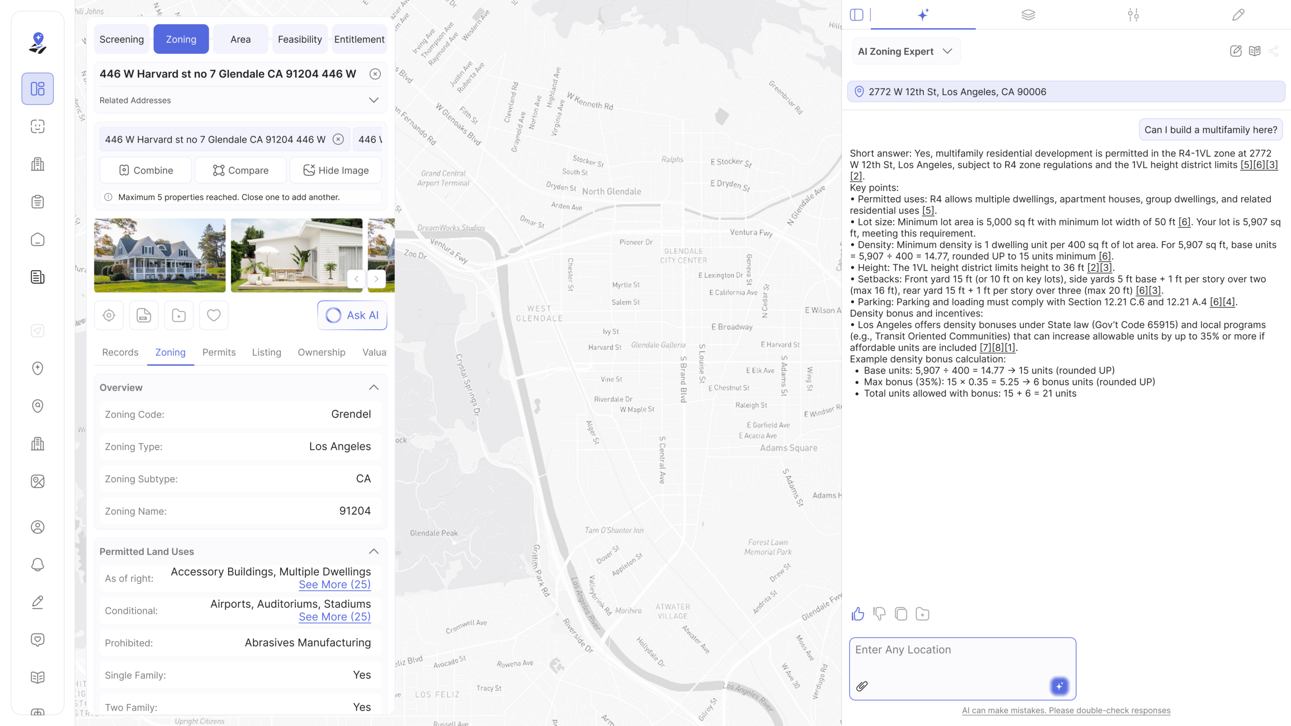
What Archiwise surfaces the moment you click any parcel:
- Full zoning designation – base zone, height district, [Q] conditions, overlay zones
- Permitted uses: by-right, conditional, and prohibited – from the applicable code
- FAR, height limits, setbacks, minimum lot area, parking, landscaping requirements
- TOC tier, QCT eligibility, DDA status, Low Income Housing/LIHTC precedents, SB79
- Hazard layers – seismic rating, fault proximity, flood zones, fire hazard, methane
- Assessed value, land value, improvement value, last sale price
- Neighborhood demographics – renter share, rent burden, median income
For any question the data doesn’t immediately answer – the AI Zoning Expert is one click away.
Frequently Asked Questions About Zoning AI
What is zoning AI?
Zoning AI is software that uses artificial intelligence to read, interpret, and apply zoning regulations to specific parcels of land. Unlike lookup tools that display zoning data, zoning AI answers plain-language questions about what can be built on a specific site, what approvals are required, and what constraints and incentives apply – drawing from live parcel data and planning documents for the specific jurisdiction.
How is zoning AI different from ZIMAS or municipal portals?
Municipal portals like ZIMAS show zoning data comprehensively – but only for their specific city. ZIMAS covers Los Angeles city limits only. Zoning AI platforms like Archiwise cover parcels nationwide and go further: instead of showing the data, they interpret it. ZIMAS tells you a parcel is zoned [Q]C4-1XL-CDO. Zoning AI tells you what that means for your project – what you can build, what approvals you need, and what the constraints are.
Can general AI tools like ChatGPT do zoning analysis?
General AI tools can explain zoning concepts and reason through scenarios you describe. They cannot look up the current zoning for a specific address, tell you whether a parcel qualifies for a TOC density bonus, or surface parcel-specific [Q] conditions. They draw on training data, not live parcel records or jurisdiction-specific planning documents.
Is zoning AI accurate enough to rely on?
Zoning AI is accurate enough for pre-application research – evaluating sites, identifying constraints, screening incentive eligibility, and making go/no-go decisions before committing money. For final entitlement decisions and complex approvals, professional review remains essential. Zoning AI does the research. Licensed professionals handle the application.
Does zoning AI work outside Los Angeles?
Purpose-built zoning AI platforms like Archiwise cover parcels nationwide. The knowledge base includes planning documents across cities, counties, and states throughout the US – not just Los Angeles.
Analyze any parcel with Archiwise – zoning, hazards, incentives, and AI interpretation in seconds.
Learn more
ArchiWise helps developers, investors, architects, and brokers go from address to decision in minutes, not weeks.
Whether you’re screening sites for multifamily development, evaluating zoning constraints, surfacing incentive eligibility like QCT and LIHTC, or assessing hazard risk before committing capital, ArchiWise runs every layer of analysis in one place.
Explore how ArchiWise helps teams screen development sites, analyze zoning, and make confident go/no-go decisions faster.