You’re looking for a multifamily site. You want density, a real entitlement path, and you want to move before the market catches up.
Start with transit.
Not because of the commute story or the parking savings -though both matter – but because a new state law has redrawn what you can build within half a mile of qualifying transit stops. SB 79, signed October 10, 2025 and effective July 1, 2026, allows up to 95 feet and 160 dwelling units per acre near heavy rail, light rail, and qualifying BRT lines across 8 California counties. That’s not a density bonus layered on top of local zoning. That’s a separate entitlement path that can override local zoning entirely.
The sites it unlocks are already on the map. Most haven’t been acquired yet. The question is whether you’re looking at the right map – and whether you know what separates one eligible parcel from the next.
What SB 79 Actually Changes
SB 79 takes effect July 1, 2026 in incorporated cities across 8 counties: Los Angeles, San Francisco, Alameda, San Mateo, Santa Clara, Sacramento, Orange, and San Diego.
Up to 95 feet in height and 160 dwelling units per acre near qualifying transit. The distance zones:
- Within 200 ft – adjacent zone, highest density
- Within ¼ mile – standard eligibility
- Within ½ mile -Tier 2 transit
Tier 1 is heavy rail and very high frequency commuter rail. Tier 2 is light rail, high-frequency commuter rail, and qualifying BRT. Minimum 5 units at 30 du/acre. No labor requirements at or below 85 feet; prevailing wage above that.
SB 79 stacks with SB 35, SB 423, and the State Density Bonus Law. One hard constraint: it cannot be used to demolish rent-stabilized buildings with 3 or more units.
How Archiwise Maps SB 79
Archiwise has a dedicated SB 79 layer that maps transit tier, distance zone, and proximity rings directly on the map. Click any parcel inside an eligible zone and the platform tells you exactly where it sits: which tier, how far from the stop, and what that means for what you can build.
To turn it on, open Layers → Housing Incentives and toggle on SB79 Transit-Oriented Development.
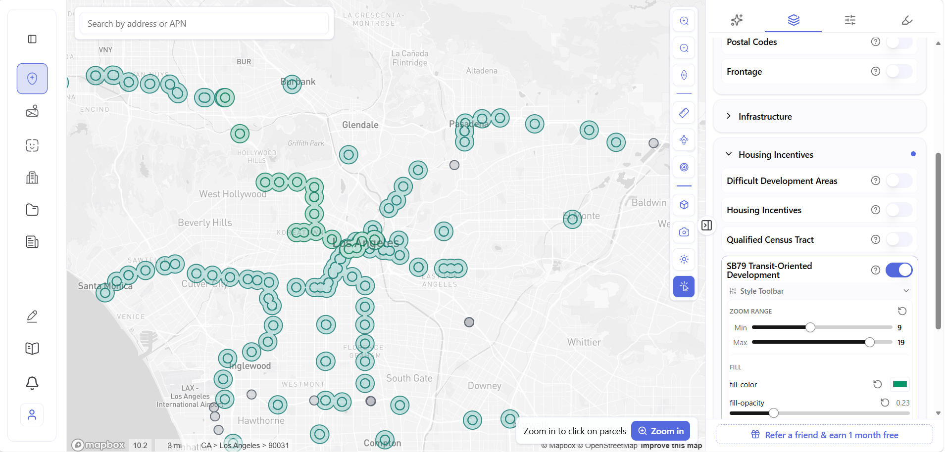
The teal clusters trace qualifying transit stops across the region. The rings around each cluster are the legal distance bands from the law – innermost at 200 ft, middle at ¼ mile, outer at ½ mile for Tier 2. A parcel in the inner ring has stronger entitlement potential than one at the outer edge, even though both show up teal.
You’re not clicking parcels yet. You’re reading the map -looking for corridors with dense clustering, older residential fabric, the kind of neighbourhood where the existing stock is underbuilt relative to what SB 79 now allows.
The corridor along E Cesar E Chavez Ave in Boyle Heights catches your eye. Dense Tier 2 markers. Low-rise residential. A zip code with strong renter demand and historically high rent burden. You zoom in.
Walking the Corridor -Three Candidates
Click the first teal marker. The SB79 popup and parcel panel open together.
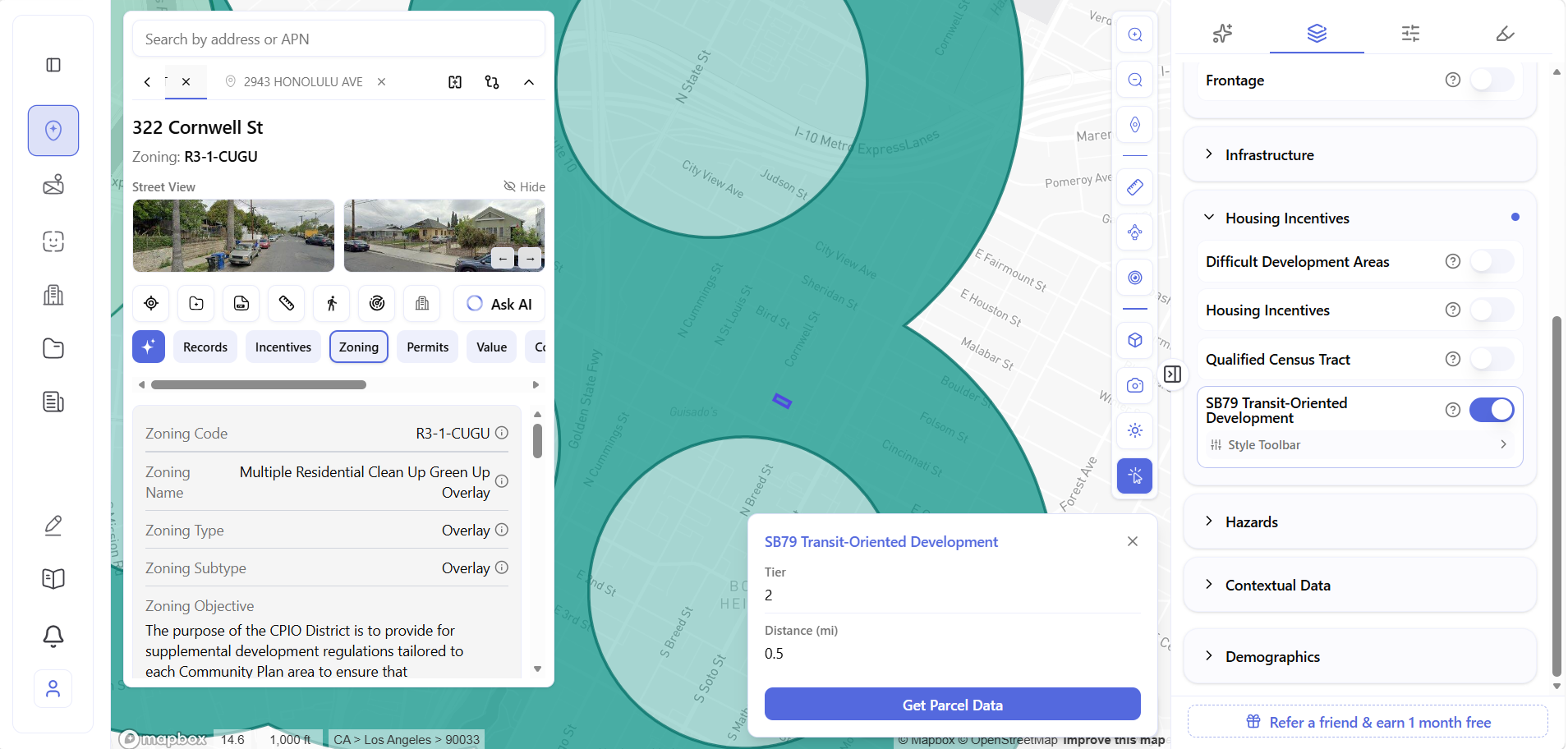
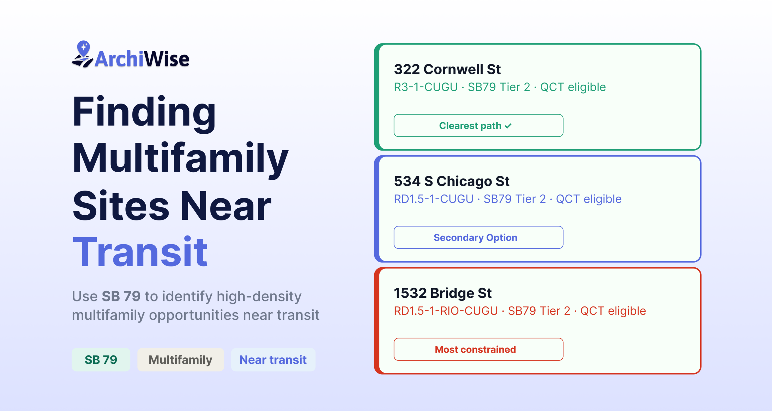
322 Cornwell St -R3-1-CUGU. Tier 2, 0.5 miles. R3 -1 base zone allows one unit per 800 sq ft -the most density-friendly base zone in this corridor. CUGU overlay only, no additional complications.
Move along the corridor. Two more parcels stand out.
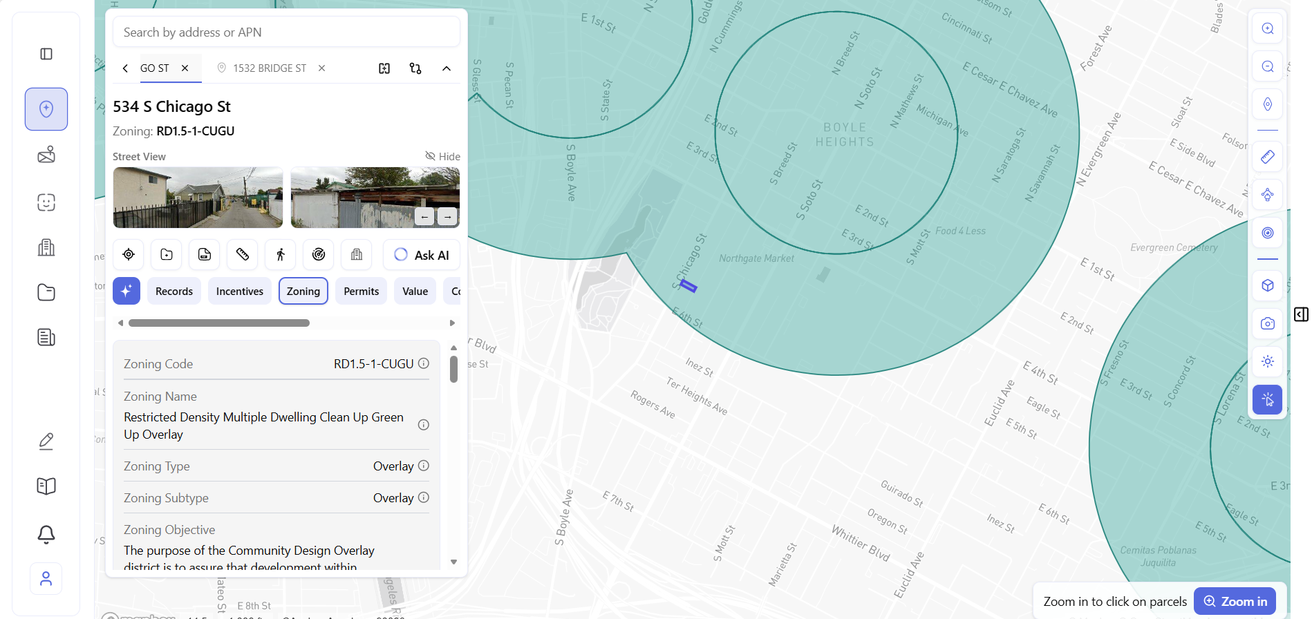
534 S Chicago St -RD1.5-1-CUGU. Same tier, same distance. Larger lot at 8,028 sq ft. RD1.5 base zone allows one unit per 1,500 sq ft – lower base density than 322 Cornwell, but no additional overlay complications.
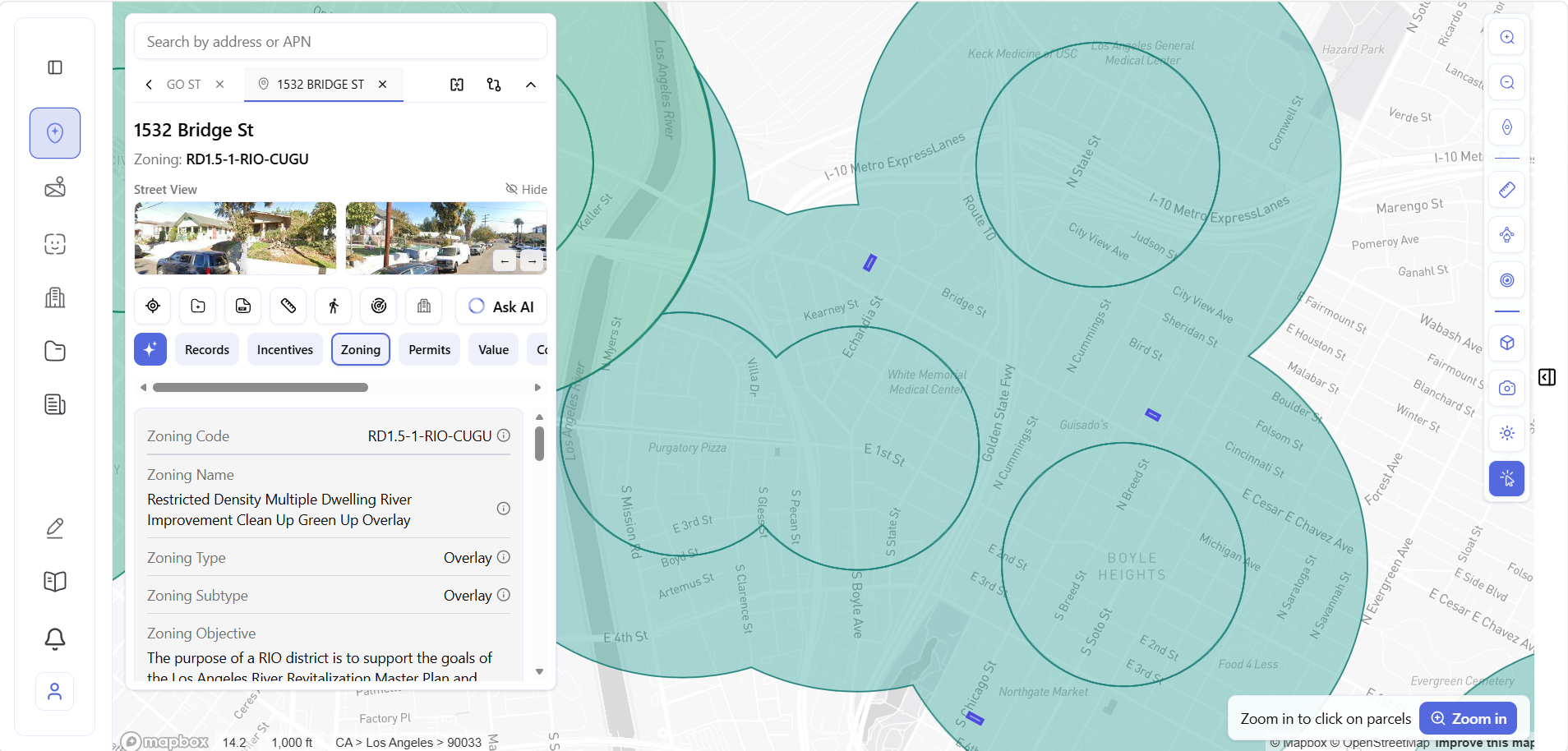
1532 Bridge St -RD1.5-1-RIO-CUGU. Same tier, same distance again. But this one carries an extra overlay – the RIO district ties development to the LA River Revitalization Master Plan. Three overlays stacked, and a 75% minimum landscaped space requirement that the other two don’t carry.
Three candidates identified. Same SB 79 eligibility on paper. Time to compare.
Comparing Three Parcels at Once
Select all three and open Compare Properties – then scroll through the tabs.
Zoning -three codes, three different regulatory stacks.
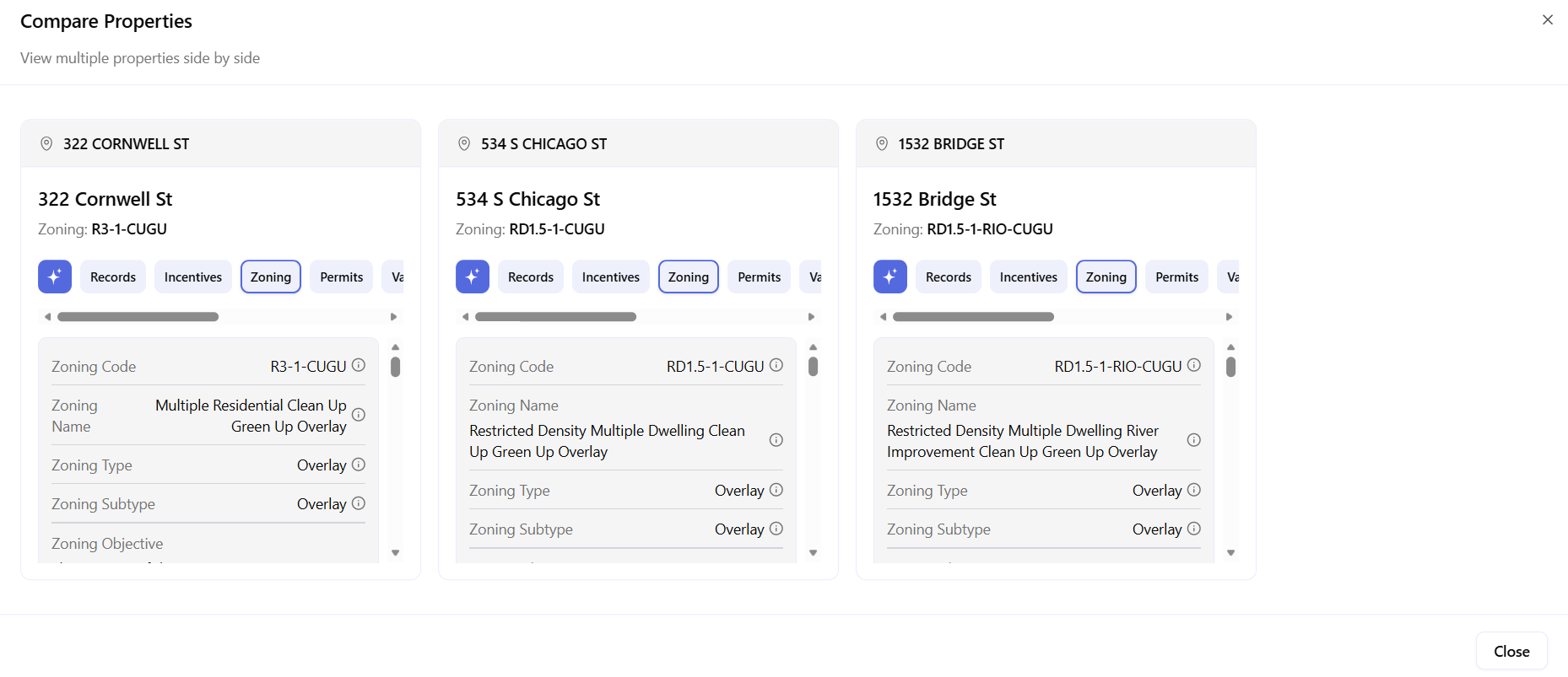
Side by side, the difference is immediate. 322 Cornwell carries the lightest regulatory stack. 534 S Chicago adds a restricted density base. 1532 Bridge adds the RIO overlay on top – the most constrained of the three.
Incentives -SB 79 and QCT confirmed on all three.
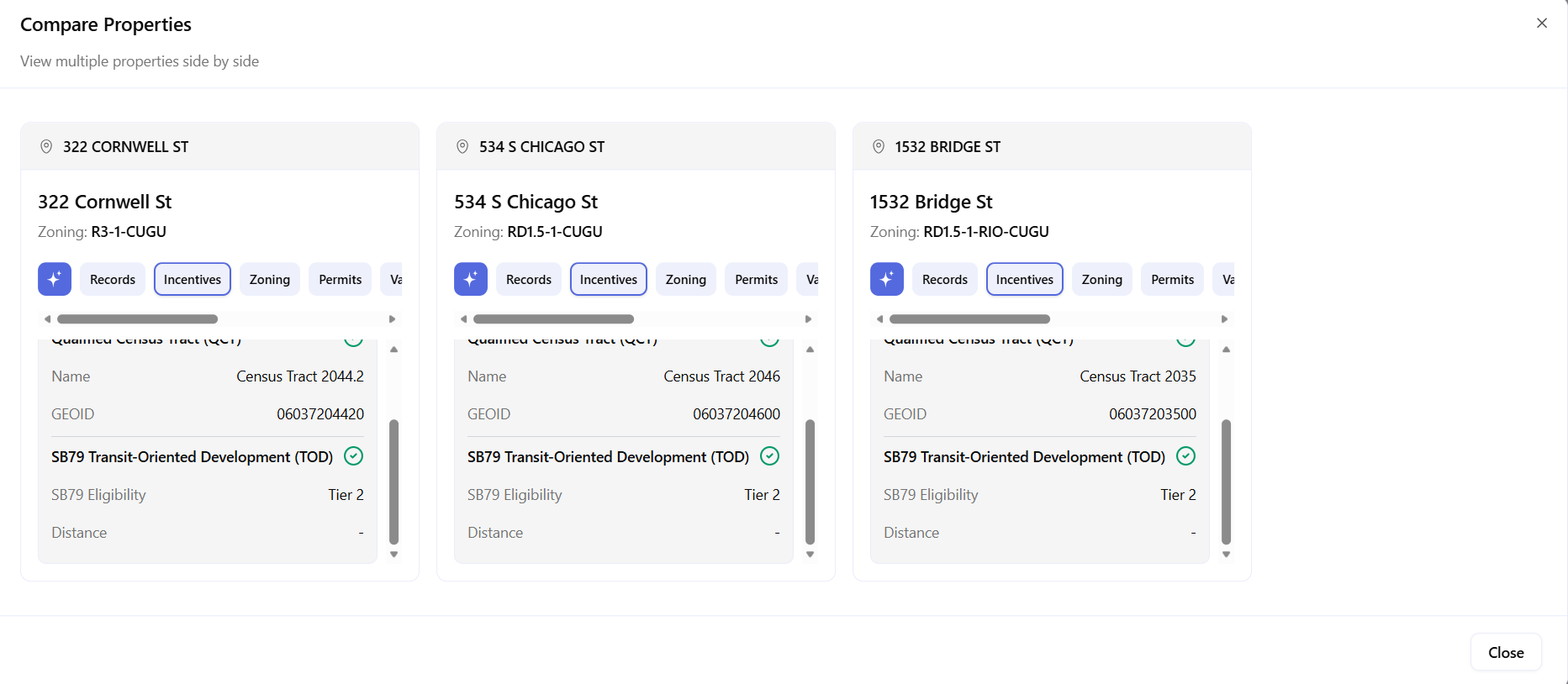
All three show SB79 ✓ Tier 2 – and all three sit in Qualified Census Tracts. QCT status opens the door to LIHTC financing and additional density bonus stacking on top of SB 79. On the incentives tab the three parcels look identical. The value tab is where the next difference surfaces.
Value – the financial signal.
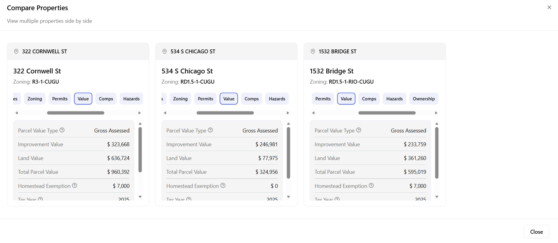
534 S Chicago shows $246K in improvements on only $77K of land – the structure is worth more than the site, an unusual signal worth investigating before underwriting. 322 Cornwell carries the strongest land value at $636K, reflecting its better base zoning. 1532 Bridge sits in the middle – but the RIO overlay and landscaping requirement make that price less attractive relative to the other two.
Asking the Right Question
With three parcels compared and one emerging as the lead, the AI Zoning Expert answers the question a developer actually needs -not how each zone works in isolation, but how SB 79 interacts with all three at once, and which has the clearest path forward.
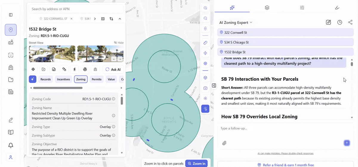
The answer confirms what the data suggested: 322 Cornwell St has the clearest path. R3 -1’s 800 sq ft minimum unit area aligns best with SB 79’s standards. No overlay complications beyond CUGU. 534 S Chicago is the secondary option -larger lot, no RIO, but higher minimum unit area under RD1.5. 1532 Bridge is third, with the RIO overlay and 75% landscaping requirement making it the hardest to develop of the three.
The AI Zoning Expert draws from the applicable zoning code, community plan, and state legislation simultaneously, with sources cited in every response. It doesn’t replace entitlement counsel. It means you walk into that conversation already knowing the right questions.
What This Workflow Gives You
Layer on. Corridor identified. Three candidates found and compared across zoning, incentives, and value. One AI question answered across all three simultaneously. That’s a morning’s work, not a week’s.
The Boyle Heights corridor is one example. The same search runs on any qualifying transit stop in Los Angeles, San Francisco, San Diego, Oakland, Sacramento – any city in the 8 SB 79 counties. Archiwise covers parcels nationwide. The SB 79 layer, the Compare view, and the AI Zoning Expert work the same way regardless of jurisdiction.
The sites are there. Most haven’t moved yet. The finding is a matter of knowing where to look – and what separates one teal dot from the next once you do.
Learn more
ArchiWise helps developers, investors, architects, and brokers go from address to decision in minutes, not weeks.
Whether you’re screening sites for multifamily development, evaluating zoning constraints, surfacing incentive eligibility like QCT and LIHTC, or assessing hazard risk before committing capital, ArchiWise runs every layer of analysis in one place.
Explore how ArchiWise helps teams screen development sites, analyze zoning, and make confident go/no-go decisions faster.