
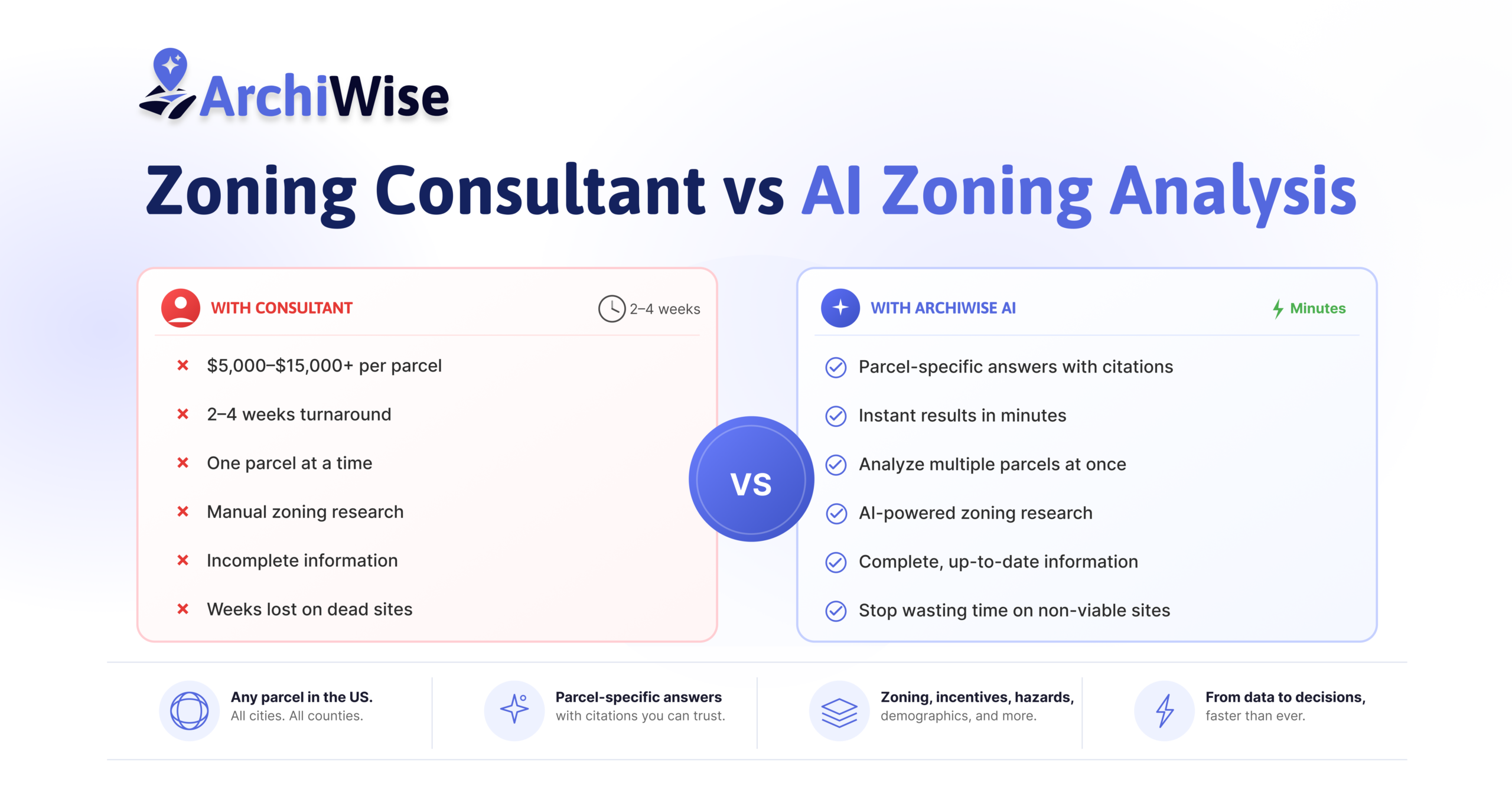

Zoning Consultant vs. AI Zoning Analysis
An Archiwise guide for developers and investors
AI zoning analysis has changed what the first move in site evaluation looks like. Here’s what it actually does – and why fewer developers are starting with a consultant call.
Every developer evaluating a site used to face the same starting point: call a consultant, or do the manual research yourself, both slow and both expensive per site. AI zoning analysis changed that starting point. A platform like Archiwise now answers the questions that used to require a consultant engagement – what can be built, by right, on a specific parcel, what incentives apply, what the constraints are – in minutes, for any address in the US, with the governing code cited.
This isn’t a claim that zoning consultants have no role left. For the deals that genuinely need agency relationships or discretionary approval strategy, they still do. But for the research that determines whether a site is worth pursuing at all – which used to eat days and thousands of dollars per parcel – that work has moved almost entirely to AI. This article lays out exactly what that shift looks like in practice.
The Old Way: Slow, Expensive, One Parcel at a Time
Before AI zoning platforms existed, evaluating a site meant a consultant engagement from the start – and that process was never built for speed.
It typically ran like this: find a consultant familiar with the jurisdiction, agree on scope, and pay a retainer before any research begins. Zoning research alone can run up to $315 an hour in markets like California (source), and a basic feasibility study for a smaller residential or multi-family project typically costs $5,000–$15,000 (source), scaling well past that for larger commercial projects. Turnaround on a standard feasibility study is commonly 2–4 weeks, though some firms offer rush service in 1–2 weeks (source). Any follow-up question after delivery – “what if we add five more units” – is often a new round of billed time. And if you’re evaluating ten candidate parcels to find the one or two worth pursuing, that entire cycle runs ten times, at full cost each time.
None of this reflects poorly on the people doing the work – it’s genuinely careful, professional research. The problem was always using a process built for entitlement strategy to answer a much simpler, much earlier question: is this site even worth pursuing? That’s the question AI zoning analysis was built to answer instead – in minutes, at a fraction of the cost, before a consultant ever needs to get involved.
It’s worth separating this from the timeline for actually securing approvals. Formal entitlements – especially anything requiring a discretionary review, a rezoning, or a contested approval – typically take a few months to several years (source), not weeks, regardless of which research method got you there. AI zoning analysis speeds up the research and screening phase. It doesn’t shorten the municipal approval process itself, and no honest comparison should imply otherwise.
Where a Consultant’s Judgment Still Matters
A good consultant brings things AI doesn’t replace: direct relationships with the planning agency that matter on contested or politically sensitive approvals, and a professional signature behind a feasibility conclusion. For the entitlement strategy on a committed site – especially one headed toward a discretionary or contested approval – that judgment is worth paying for.
What consultants were never built to do well is the part that comes before that stage: fast, cheap, repeatable research across many candidate sites at once. That’s not a knock on the people doing the work – it’s simply not what billable-hour, one-parcel-at-a-time research was designed for. That’s the gap AI zoning analysis fills.
What AI Zoning Analysis Actually Brings to a Deal
This is where most comparisons get the framing wrong. AI zoning analysis isn’t trying to replicate a consultant’s judgment on a contested rezoning. It’s replacing the slow, expensive, repetitive research phase that happens before anyone would call a consultant – the work that determines whether a site is worth that call in the first place.
A Dedicated Zoning Layer, Not a Lookup
Most of what makes this possible starts before you’ve clicked a single parcel. Archiwise has a dedicated nationwide Zoning map layer – toggle it on and every parcel in view is color-coded by district, labeled, and visible all at once, across an entire neighborhood or corridor, in any city or state in the US.
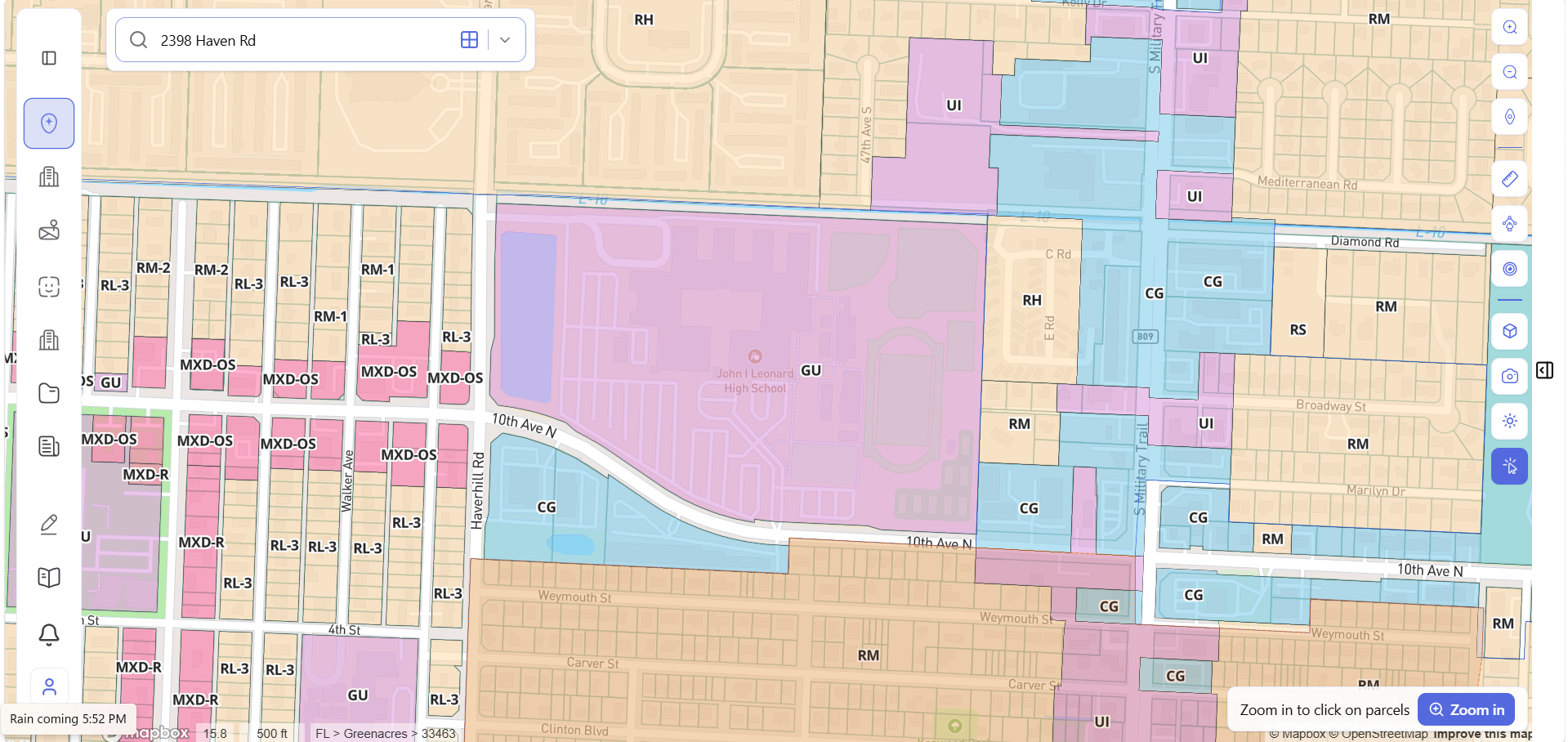
The layer isn’t just a colored overlay – it’s built on a structured legend covering every category a developer would need to distinguish at a glance: Residential (Single Family, Two Family, Multi Family, Mobile Home Park), Commercial (General, Core, Neighborhood, Retail, Special, Office), Industrial (Light, Heavy, Manufacturing, Storage), and more, each with its own toggle and styling control.
A zoning consultant works one parcel at a time, because that’s how the underlying research has to be done – pull the code, read the designation, repeat. The dedicated zoning layer flips that order. You see the whole pattern of a neighborhood first – where the multifamily zones cluster, where industrial buffers a residential block, where a corridor shifts from commercial to residential – and only then zoom in to pull the full rule set for the specific parcel that looks right. That’s not a faster version of the old process. It’s a different starting point entirely, and it’s one no manual lookup or per-parcel consultant engagement can offer.
A Real Example: 2772 W 12th St, Los Angeles
A developer wants to know: can I build multifamily here, and what would it look like?
Typed directly into the Archiwise AI Zoning Expert: “Can I build a multifamily here?”
The answer comes back in seconds – not a general description of what the zone “typically” allows, but a parcel-specific breakdown:
- Multifamily is permitted by right in the R4-1VL zone
- Base density: 15 units, calculated from the parcel’s 5,907 sq ft lot at 400 sq ft per unit
- Height limit: 38 ft under Height District 1VL
- Setbacks: front 15 ft, side 5 ft, rear 15 ft
- Density bonus: 6 additional units at 35% maximum, for 21 units total
- Every figure cited to its source – Gov’t Code 65915, LAMC 12.21 C.6, 12.21 A.4, and more
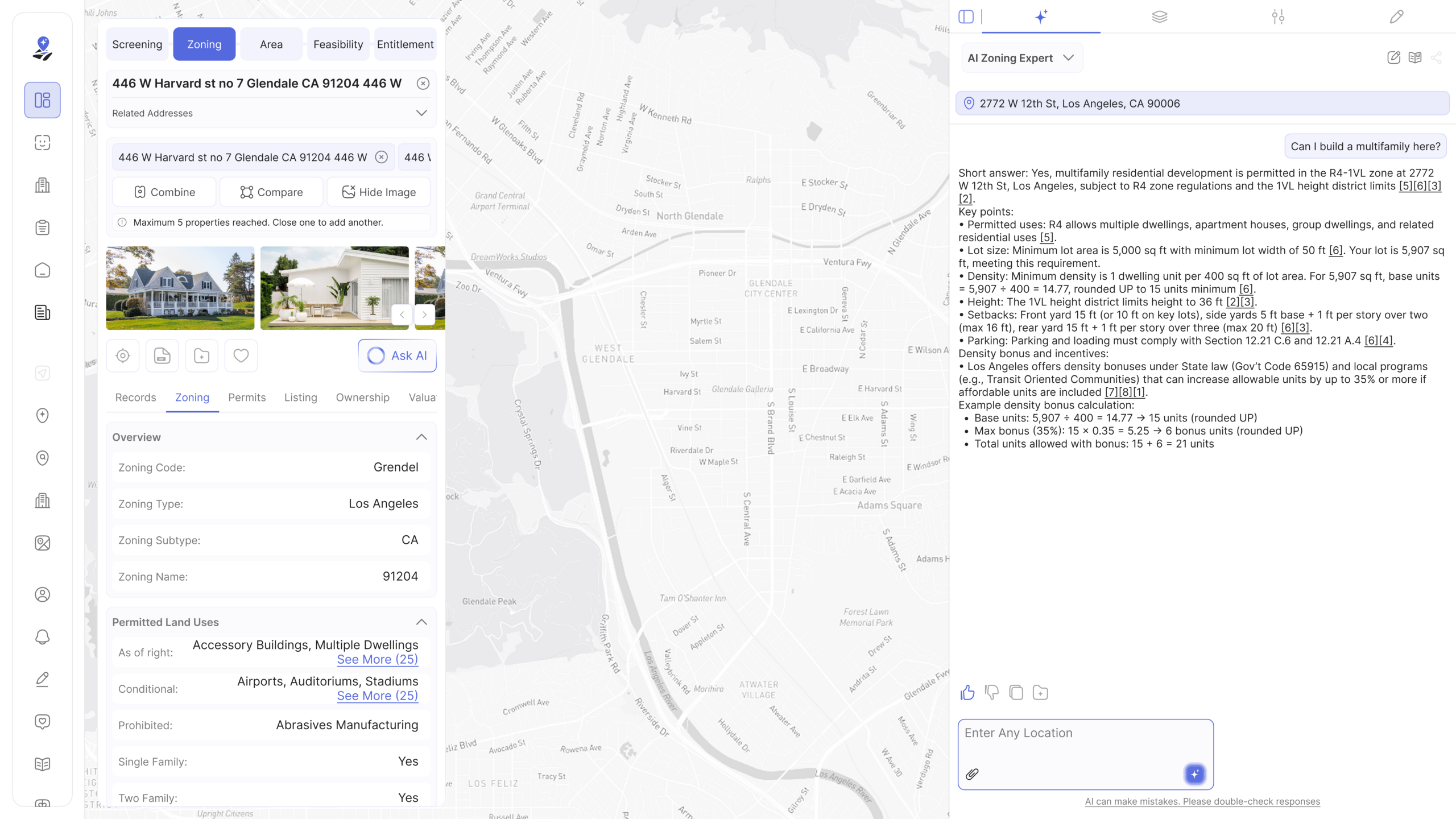
That’s the category of analysis a basic feasibility/zoning research engagement would normally cost several thousand dollars and take two to four weeks to deliver. Here, it’s included with a subscription and immediate.
What the Platform Surfaces the Moment You Click a Parcel
Beyond direct AI questions, every parcel comes with a full data panel, organized into nine tabs:
- Records – core parcel identifiers: APN, legal description, lot area, jurisdiction
- Incentives – TOC tier, QCT status, DDA designation, SB 9, SB 35, SB 79, AB 2011 eligibility, and nearby LIHTC precedents
- Zoning – base zone, height district, [Q] conditions, overlays, FAR, height limit, setbacks, lot coverage, density, parking, and permitted uses split into three explicit lists: as of right, conditional, and prohibited
- Permits – permit history tied to the parcel
- Value – assessed land value, improvement value, last sale price
- Comps – comparable properties
- Hazards – seismic rating, fault proximity, flood zone, fire hazard severity, methane risk
- Ownership – owner name, ownership type, and mailing address
- Demographics – renter share, rent burden, median income for the surrounding area
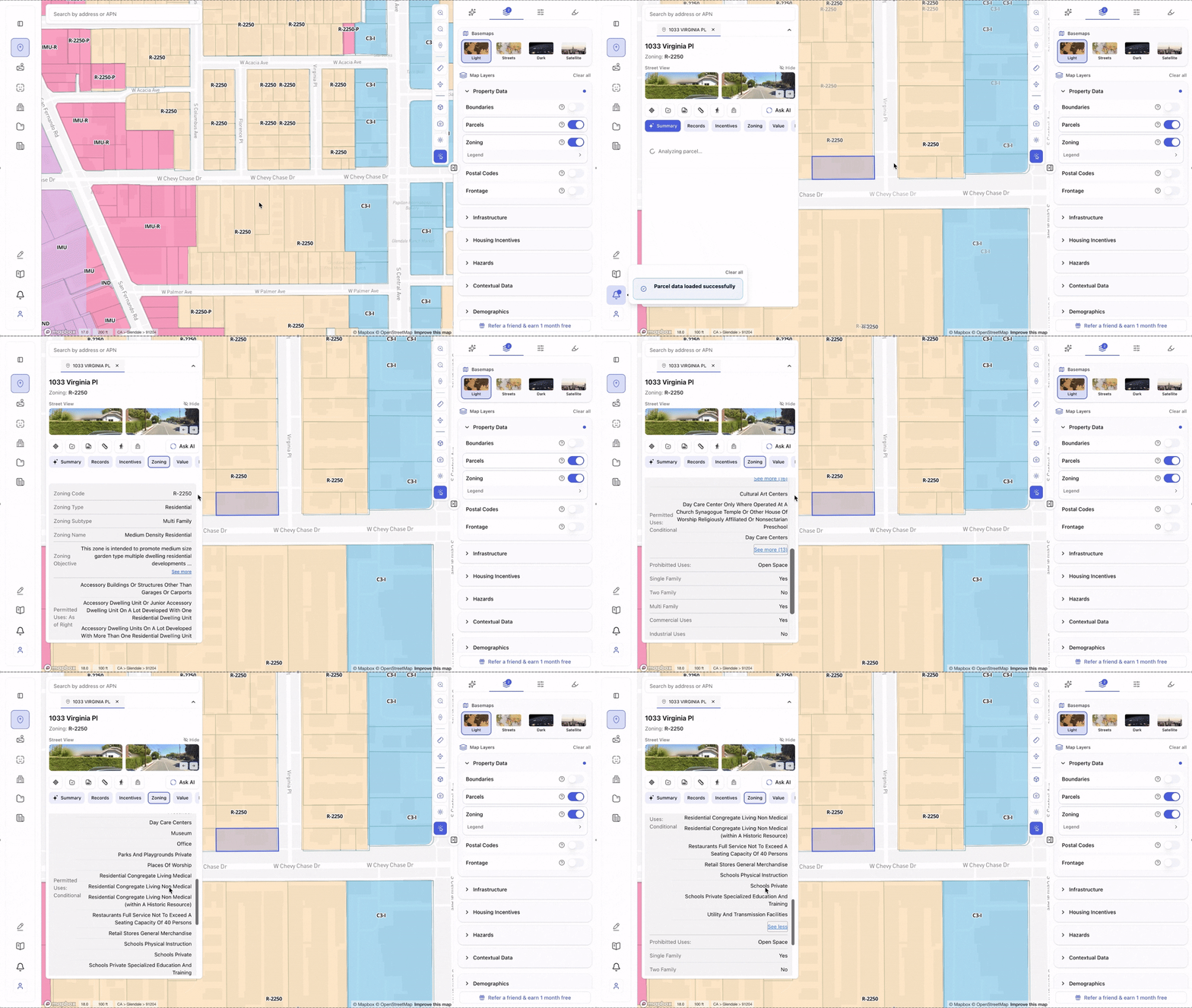
The level of detail goes well beyond a zone code and a number. Setback exceptions, cross-referenced tables in the underlying ordinance, conforming-use carveouts for properties developed under an older standard – the kind of granular, codified language a person would otherwise have to read directly out of the municipal code, line by line — is already pulled, organized, and linked back to its source the moment a parcel is clicked.
The permitted-uses breakdown alone is worth dwelling on, because it’s the part of a zoning code that’s most tedious to assemble by hand and most consequential to get wrong. Every parcel’s Zoning tab splits land uses into three explicit, fully expandable lists, pulled directly from the applicable code – every use permitted as of right, every use permitted conditionally, and every prohibited use, in full, not just a representative sample.
That three-way split – as of right, conditional, prohibited – is the single most important distinction in any zoning analysis, because it’s the difference between a use you can build without discretionary review and one that triggers a separate approval process entirely. Manually compiling this list means reading the entire use table in the applicable code section and sorting every entry by hand. Here, the complete list is already sorted, for the specific parcel, before you’ve asked a single question.
One Knowledge Base, Every Pre-Development Question
The permitted-uses breakdown and the rest of the Zoning tab are themselves only a summary view. Behind them sits the AI Zoning Expert – a chat interface built on a knowledge base of thousands of planning documents: zoning codes, specific plans, general plans, community plans, overlay ordinances, and state legislation, spanning cities, counties, and states across the US.
The distinction matters because a tab full of fields can only show what fits into a fixed set of categories. A real pre-development question rarely stays inside those categories. “What’s my by-right unit count if I include an ADU?” “Does the density bonus stack with the TOC tier here?” “What triggers discretionary review under this overlay?” – these are the questions a developer actually needs answered, and they’re exactly what the AI Zoning Expert is built to handle: reading across the relevant documents for that specific parcel’s jurisdiction, reasoning through the answer, and citing the source section it came from. It isn’t limited to the fields in the data panel – it’s grounded in the full text of the documents that panel was built from.
Screening Before You Even Know an Address
For developers sourcing sites rather than evaluating a known address, Archiwise offers several ways to filter the map without needing a specific address. Draw Search Area lets you outline a custom polygon on the map. Viewport filtration filters everything currently visible on screen. Zip or city filtration lets you target a specific zip code or municipality instantly. Whichever approach fits the workflow, every parcel inside the selected area can be filtered by lot size, zoning designation, ownership type, vacancy status, assessed value range, demographics, or walking/driving distance from a point of interest like a transit station.
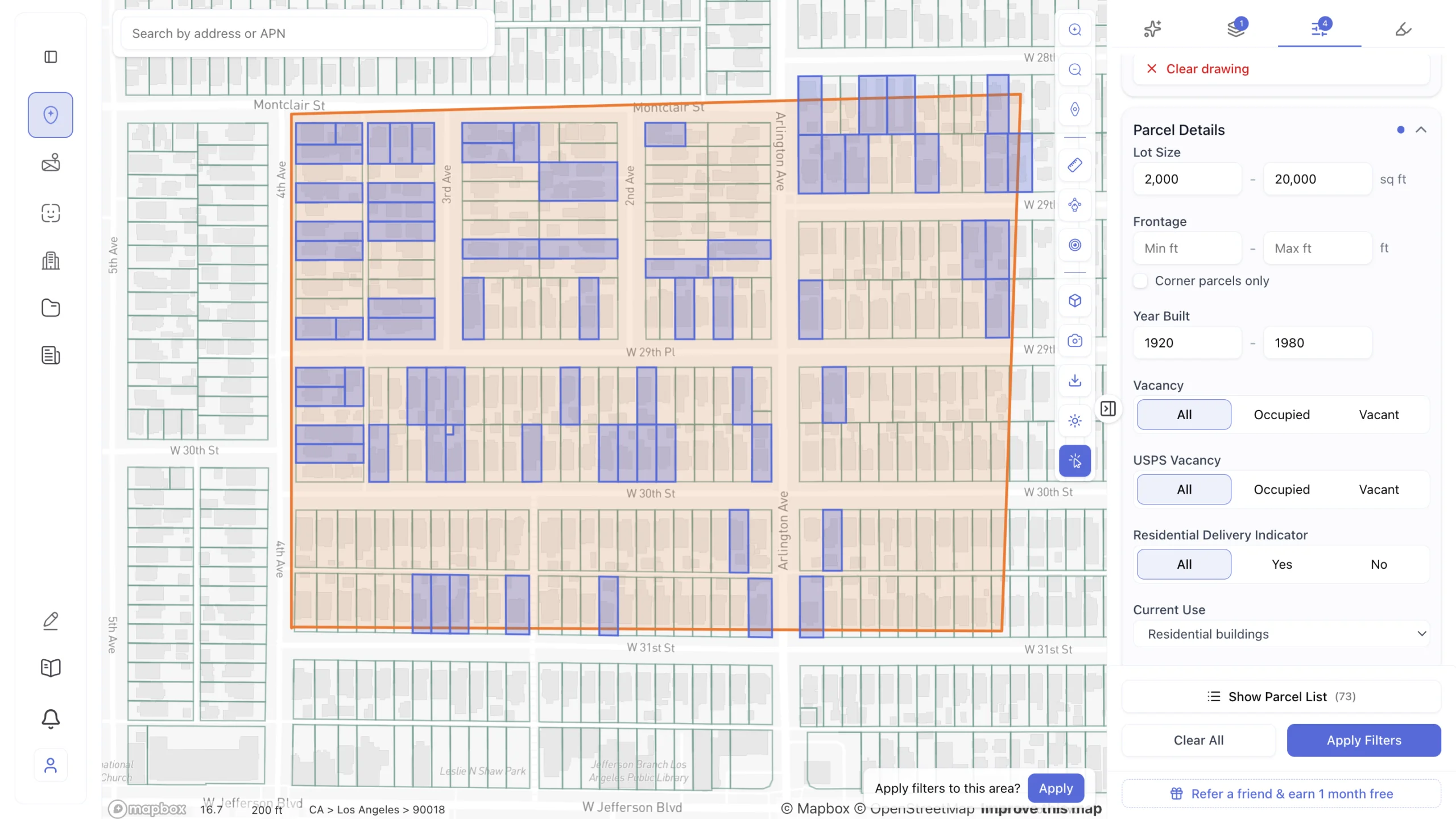
In practice, the filtering happens in layers, each one narrowing the field without ever leaving the map. Start broad with lot size and year built to match a project’s basic footprint. Add last sale price and current use to align the shortlist with an acquisition range. Layer in demographics – income levels, poverty rate, age distribution, education levels – to confirm the market actually fits the product before spending another minute on it. What started as fifty or a hundred parcels narrows, filter by filter, into a handful of sites actually worth opening.
Once the shortlist is tight, switch to list view: a table of every matching parcel with address, zoning, lot area, owner, and the rest of the filtered fields, ready to export as a CSV or add directly to a project.
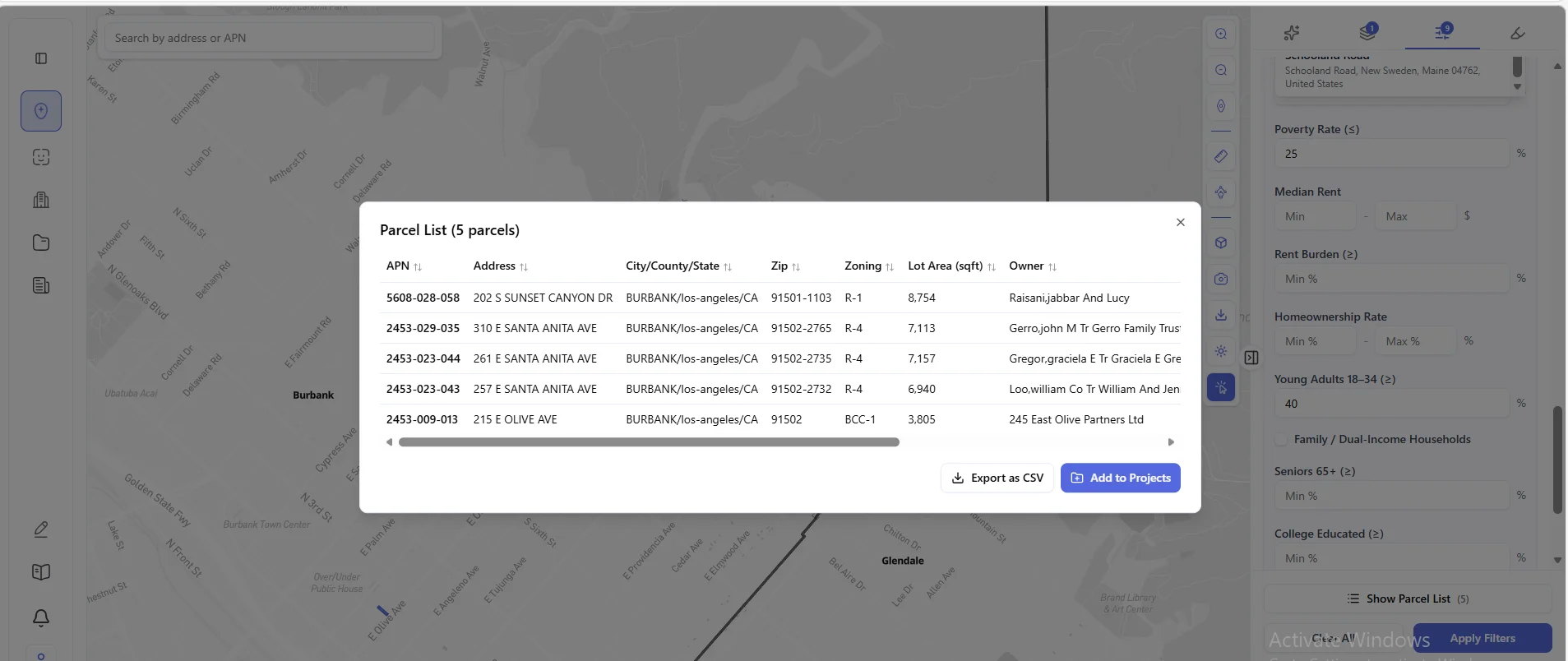
No zoning consultant – no matter how good – can do any of this. You need an address before a consultant can start. Archiwise finds the addresses worth calling them about.
Evaluating More Than One Parcel at Once
Archiwise supports up to five parcels simultaneously, showing combined lot area, total value, and a land-versus-improvement breakdown – then lets you ask the AI about the assemblage directly: whether multifamily is permitted by right on the combined site, what the lot merger requirements are, and what constraints could affect the project.
The Deal-Killers That Don’t Show Up Until It’s Too Late
Some of the most expensive mistakes in site selection aren’t zoning mistakes at all. Sewer access too far from the site. Pipelines crossing the parcel. Limited electrical capacity. These are infrastructure problems, not zoning problems, and they routinely surface late – sometimes after a project is already in contract – because they live in utility company records, not the zoning code a consultant or developer would normally check first.
Archiwise surfaces gas, electric, and sewer infrastructure as map layers alongside the Hazards tab data – fire hazard zones, flood zones, earthquake faults, seismic hazard, and methane areas – so infrastructure and environmental risks get screened at the same stage as zoning, not discovered three months into due diligence after calls to three separate utility companies that should have happened on day one.
Zoning and infrastructure answer whether a site is buildable. They don’t answer whether the market is actually moving. For that, a quick check against projects under construction, active listings, and leasing velocity nearby confirms or challenges the assumptions baked into a shortlist before a consultant engagement – or a contract – commits real money to them.
Side-by-Side: Screening Ten Sites
The gap between the two approaches is clearest when a developer isn’t evaluating one site – they’re trying to find the right one among many.
Consultant-first. Engaging a consultant to evaluate ten candidate parcels means ten separate research cycles, each on the order of 2–4 weeks at standard turnaround (source). Even with a batch discount, that’s realistically a month or more before you have enough information to rank the sites against each other – and that’s before you’ve negotiated terms on any of them.
AI-first. Run all ten addresses through Archiwise. Within an hour, you have zoning, by-right unit count, height and FAR limits, incentive eligibility, hazard exposure, and assessed value for every site. You rank them immediately. The two or three that actually pencil go to a consultant for the deeper entitlement work that genuinely needs professional judgment.
The AI-first approach doesn’t remove the consultant from the picture – it changes when they get involved and how many sites they’re paid to look at. That’s the real economic argument for AI zoning analysis: it isn’t a cheaper substitute for consulting, it’s a filter that makes sure consulting dollars only go toward sites that have already cleared the basic feasibility bar.
Where AI Zoning Analysis Has Real Limits
A platform that pretends to replace professional judgment entirely isn’t being honest with you, so a brief, direct note on the boundaries: when multiple overlays, [Q] conditions, and specific plans stack on a single parcel, Archiwise flags the interactions for review rather than silently resolving them. For contested rezonings, CEQA-triggered projects (or equivalent environmental review outside California), or politically sensitive approvals, the work depends on agency relationships, not just correct interpretation of a code – and no platform replaces that. And because codes change, time-sensitive conclusions on an active deal are still worth a quick verification pass, even though Archiwise’s knowledge base updates continuously.
The honest framing: AI zoning analysis owns the research phase – fast, cited, and effectively free per parcel once you’re on the platform. That covers the overwhelming majority of the pre-application work on most deals. A consultant’s judgment is still the right call for the smaller slice of sites that are genuinely contested, ambiguous, or headed toward discretionary review.
How the Two Fit Together, Stage by Stage
| Deal Stage | Who Does the Work |
| Sourcing – finding candidate sites in a target area | AI zoning analysis (Draw Search Area, filters) |
| Initial screening – zoning, by-right density, incentives, hazards | AI zoning analysis |
| Ranking multiple sites against each other | AI zoning analysis |
| Assemblage feasibility across adjacent parcels | AI zoning analysis |
| Verifying ambiguous or stacked conditions on a shortlisted site | Consultant, informed by the AI’s flagged questions |
| Formal entitlement strategy on a committed site | Consultant |
| Contested rezonings, CEQA review, agency negotiation | Consultant |
Zoning Consultant vs. AI Zoning Analysis: Head-to-Head
| Zoning Consultant | AI Zoning Analysis (Archiwise) | |
| Turnaround per parcel (research/feasibility phase) | 2–4 weeks (1–2 weeks rush) (source) | Minutes |
| Cost per parcel (research/feasibility phase) | $5,000–$15,000+ (source); zoning research alone up to $315/hr (source) | Included in platform subscription |
| Screening multiple sites | Linear – each site billed separately | Parallel – screen dozens in one sitting |
| Source citations | Verbal or memo-based | Numbered citations to the specific code section |
| Multi-parcel assemblage math | Manual | Automatic, up to 5 parcels |
| Site sourcing without a known address | Not possible | Draw Search Area, viewport filtration, zip or city filtration |
| Exportable shortlist (CSV) across filtered parcels | Not possible | Yes – list view, export, add to project |
| Infrastructure risk (sewer, gas, electrical capacity) | Requires separate utility company calls | Map layer, screened alongside zoning |
| Market activity signal (construction, listings, leasing velocity) | Separate market study, additional cost | Visible in the same workflow |
| Nationwide coverage | Varies by individual consultant’s market | Any US parcel |
| Agency relationships / negotiation | Yes | No |
| Judgment on contested, discretionary approvals | Yes | Flags for review, doesn’t replace |
| Best used for | Entitlement strategy on a committed site | Pre-application screening across many sites |
The Bottom Line
The work of figuring out what can be built on a site – the zone, the by-right density, the incentives, the constraints – has moved from a multi-week, several-thousand-dollar consultant engagement to something a developer does directly, in minutes, for any parcel in the US. That shift is the real story here. A consultant’s judgment still matters for the smaller slice of deals that are genuinely contested or headed toward discretionary review – and the formal entitlement timeline on those, often months to years, doesn’t change regardless of which research method got you there. But for the research that decides whether a site is worth pursuing in the first place, AI zoning analysis is now the faster, cheaper, and more thorough option, by a wide margin.
Screen any US parcel with Archiwise – zoning, incentives, hazards, ownership, and AI-cited analysis in minutes, before the consultant call.
Learn more
ArchiWise helps developers, investors, architects, and brokers go from address to decision in minutes, not weeks.
Whether you’re screening sites for multifamily development, evaluating zoning constraints, surfacing incentive eligibility like QCT and LIHTC, or assessing hazard risk before committing capital, ArchiWise runs every layer of analysis in one place.
Explore how ArchiWise helps teams screen development sites, analyze zoning, and make confident go/no-go decisions faster.