

A zoning answer is not a feasibility answer. The gap between them is where site screening goes wrong, and it is a short gap.
The problem: an error early in the chain survives all the way to the pro forma, and it arrives looking like a number. Rent assumptions get argued over. Construction costs get argued over. The unit count tends to be taken as given, because it came out of the zoning.
This page walks the route from code to buildable units, shows where it breaks, and gives you the check.
The six steps
- What use is allowed? By right, conditionally, or not at all.
- What density does the zone produce on this lot? Units, from the lot area.
- What law actually governs? Local code, or a state program that supersedes it.
- What envelope is left? Height, setbacks, lot coverage, floor area ratio (FAR), open space.
- How many units fit inside it? Gross floor area, efficiency, average unit size.
- Which capacity is lowest? That one sets your preliminary yield.
Step six is the one people skip. A density standard and a FAR limit are two independent ceilings on the same parcel, calculated from different inputs, and they need not land on the same number. The lower one governs – and it is frequently not the one the zoning tool quoted.
Step 1 and 2: reading the zone
A density standard is usually expressed as a minimum lot area per unit, or as units per acre. Dividing is the easy part.
The work worth doing is establishing whether your use is in the table at all, and in which column. Use tables run long – a single district can carry dozens of uses allowed by right, dozens more requiring a conditional use permit, and a prohibited list running past a hundred entries. “Residential is allowed” is not an answer when a district permits single-family and two-family by right and sends multi-family to a hearing.
The second thing worth checking is whether the lot area the calculation used came from the parcel record or from a zone default. A per-lot number built on an assumed lot size is a guess wearing a decimal point.
Step 3: what actually governs
This is the step most likely to make an otherwise careful analysis wrong, because the governing rule may not live in the municipal code at all.
California is the clearest current example, and the pattern matters wherever you work: state legislatures increasingly override local zoning directly, and a tool reading the city’s code will not see it. Check your own state’s equivalents.
SB 79 took effect on 1 July 2026 in incorporated cities. It applies in urban transit counties – those with more than 15 passenger rail stations. As of July 2026 the Department of Housing and Community Development identifies seven: Alameda, Los Angeles, Sacramento, San Francisco, San Mateo, Santa Clara and San Diego. That list is not fixed. Eligibility follows transit infrastructure, so counties enter as rail projects reach revenue service – Orange County is expected to qualify once the OC Streetcar opens. The law does not reach unincorporated county areas until the 7th RHNA cycle.
Near a qualifying stop, SB 79 overrides local density limits. A Tier 1 stop is one served by heavy rail or very high frequency commuter rail; within a quarter mile of one, the statutory standards reach 75 feet, 120 units per acre and 3.5 FAR.
Those are standards for qualifying sites, not automatic entitlements. Transit-stop classification, parcel eligibility and project requirements all have to be established first. SB 79 also sets a floor – a minimum of five units at 30 units per acre, or the local minimum if higher – and buildings above 85 feet carry additional labor standards.
SB 79 does not create its own approval path and does not remove CEQA review. A qualifying project may separately qualify for streamlined ministerial approval under Government Code 65913.4 – the section SB 35 created and SB 423 extended – if it meets that section’s affordability and labor requirements. Otherwise it proceeds through the locality’s standard process.
Two more worth knowing:
- AB 2097 generally prohibits local agencies from imposing minimum automobile parking requirements on qualifying projects within a half mile of a major transit stop, subject to statutory exceptions. A parking ratio can sit in the municipal code and be unenforceable – and parking is rarely a small line in a pro forma.
- AB 2011, effective July 2023, opens two ministerial pathways on commercially zoned land: one for 100 percent affordable housing on qualifying commercial sites, and one for mixed-income housing on commercial corridors with a right of way between 70 and 150 feet. Both carry affordability and labor standards. Not every retail-zoned parcel qualifies for either.
Zoning platforms read municipal code. Supersession lives outside it, which makes this the step to verify rather than assume – whatever your tool reports.
Step 4, 5 and 6: the envelope, and the lowest capacity
The envelope is not six numbers. It is minimum lot area, depth and width stated separately per use type, maximum height, maximum lot coverage, front, side and rear setbacks with their conditional language intact – corner lots, zero lot line, common wall – open space per unit split between ground and upper levels, maximum density, and accessory structure height.
A tool that returns “side setback: 5 ft” and nothing else has dropped the clause that changes that number on a corner.
Turning the envelope into units requires two inputs the code does not supply: an efficiency ratio and an average unit size. Keep the terms straight – gross building floor area is what FAR limits; net rentable area is what remains after circulation, cores and common space; net habitable unit area is smaller still. Dividing an average apartment size into gross floor area without an efficiency adjustment overstates the unit count, sometimes badly.
Then compare the density ceiling against the envelope ceiling in the same terms, and take the lower one. That is a preliminary yield, not a final count. Parking and circulation, fire access and building separation, open space, unit mix and minimum unit sizes, accessibility and building code requirements, and local design standards can each pull it down further. We worked through this in detail in our yield study walkthrough.
One caution under a state program: whether local setback and coverage standards survive depends on the approval path and on any local implementing ordinance. That is a question for counsel, not a figure to look up.
Where it breaks
The local code is not the governing law. Covered above, and the largest of the six.
Retrieval is not interpretation. Quoting the density standard is not the same as resolving it against this parcel’s recorded area. Ask any product for a number specific to your lot and see whether you get a figure or a passage.
Overlays and special districts override the base zone quietly. Specific plans, community plan designations, historic preservation overlays and planned development districts can replace or cap what the base zone allows – sometimes removing a standard entirely rather than tightening it. Coverage of these varies by product and by market.
“Permitted” can still mean a hearing. A conditional use generally requires discretionary review – additional findings, often a public hearing, and conditions of approval. Ministerial review applies objective standards without that discretion. The process varies by jurisdiction, but both can appear in a table as the same green check.
Code goes stale. Municipalities amend. Ask when a jurisdiction’s code was last ingested; a product that cannot answer that per jurisdiction is giving you undated answers.
Split zoning. Parcels can cross two zones, particularly on corridors and at district boundaries. If a tool returns a single zone, ask how it chose.
The check
Before a number goes into a pro forma:
- Open the citation and confirm it says what the summary says. A real citation attached to a slightly wrong paraphrase is harder to catch than an obvious error.
- Check the subsection. Zoning nests. A rule in (a)(2) is not the rule in (a)(1).
- Ask for the ingest date for that jurisdiction.
- Run the state-law questions for your state. In California: is the parcel in one of the seven urban transit counties, near a qualifying stop, for SB 79? Within a half mile of a major transit stop, for AB 2097? On a qualifying commercial site or corridor, for AB 2011?
- Compute density and envelope separately and compare them in the same terms.
- Confirm the lot dimensions came from the parcel record, not a zone default.
- Ask which approval path – standard process, ministerial under a state program, or discretionary review.
If you are choosing between tools rather than checking one, we compared the main platforms in our site selection software review.
What ArchiWise does across these steps
Find the parcel. Search by address, APN or coordinates, anywhere in the US. Parcel records are nationwide.
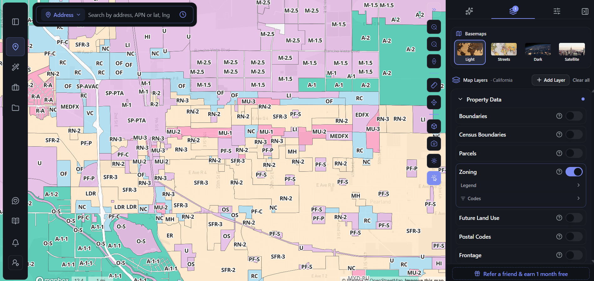
See zoning as geography. The zoning layer colors every parcel by zone across the map, with the legend and the full code list behind it, over light, streets, dark or satellite basemaps. Alongside it sit parcel boundaries, census boundaries, future land use, postal codes and frontage. Layer availability varies by market.
Screen a market. AI Site Selection finds and filters parcels across an area: zoning, land use and zoning type are search criteria rather than attributes you read after you have already found a parcel. You describe the conditions you need and get parcels back, ranked by zoning fit, hazards and feasibility.
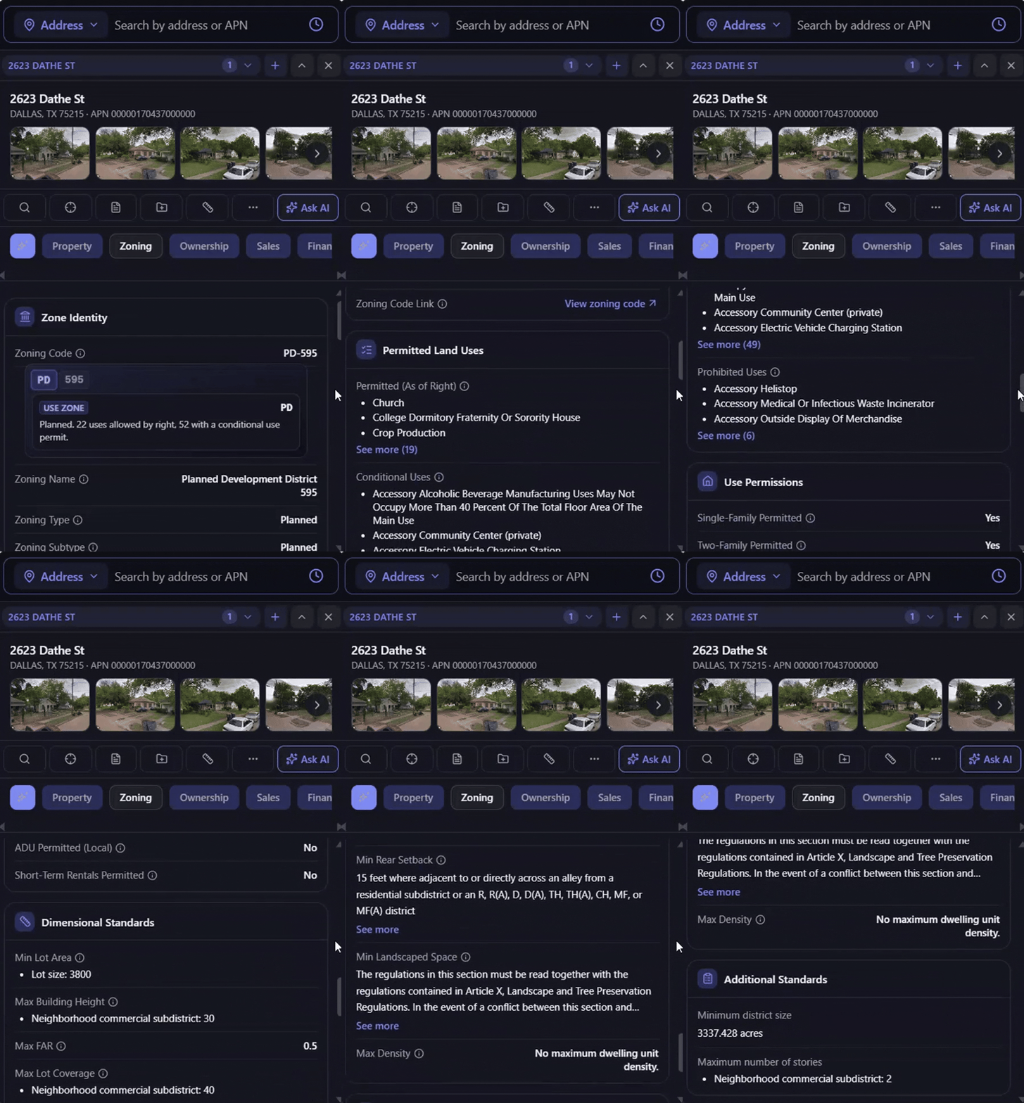
Read one zone. The AI Zoning Expert panel returns zone identity with a plain-language summary of the use zone, the permitted, conditional and prohibited use lists, yes/no permissions by category including ADU, and the dimensional set with its conditional language preserved. It also checks density bonuses, tax credit eligibility and state housing law programs, where those apply – availability varies by jurisdiction and program. Every field carries an info tooltip, and the panel links out to the ordinance and to the zoning of record so you can verify rather than trust.
Evaluate one parcel. AI Site Feasibility takes the envelope into a massing study on the real parcel geometry and returns units, area and yield, alongside the area context – hazards, infrastructure, demographics and comps.
Ask it. The AI chat answers questions on the open parcel and cites the source behind each answer, which makes the first item on the checklist a click rather than a search.
What it does not do. It does not replace a land use attorney on an entitlement path, and it will not predict how a planning department behaves. The output is a screen that makes the expensive conversations shorter.
Frequently asked questions
What is zoning feasibility analysis? Determining what can realistically be built on a specific parcel by running the zoning code, the governing state law and the physical envelope, then taking the lowest resulting capacity.
Why does the unit count differ from the zoning density? Because density and FAR are separate ceilings calculated from different inputs. Height, setbacks and open space can produce a lower number than the density standard does.
Where do AI zoning tools go wrong? Base zoning and use tables are the most established part of the category. Overlays, special districts, recent amendments and state law supersession are where discrepancies concentrate, which is why the citation and the ingest date matter.
Can I search for parcels by zoning instead of looking them up one at a time? Yes. Zoning, land use and zoning type work as search filters in ArchiWise, which is the difference between screening a market and checking a parcel.
Can it replace a feasibility consultant? No. It replaces the first hours of code reading and the first massing sketch, not the judgment about cost, absorption or approval risk.
What changed in 2026? SB 79’s provisions took effect 1 July 2026 in incorporated cities across seven California counties. Where it applies, the local density limit is no longer necessarily the governing limit near qualifying transit.
The number that reaches your pro forma should be the lowest of several, not the first of one.
Run a parcel through ArchiWise and see the zoning, the envelope and the yield in one pass.