

Ask an acquisitions team how a site reaches them and the answer is usually the same. A broker sends an address. Someone forwards a listing. A principal drives past something interesting. The parcel arrives first, and the research happens afterwards, to find out whether it was worth arriving.
That order is the problem. By the time you are researching, you have already spent the scarce resource – your team’s attention – on a parcel somebody else selected for you.
Crexi and ArchiWise AI both get mentioned as answers to this, and they get compared often. They are not the same kind of product, and the comparison becomes useful once you can say where each one’s workflow begins.
What Crexi is built around
Crexi describes its research product as Commercial Property Records & Sales Comps, and that heading is an accurate summary. It is a commercial real estate marketplace with a research layer underneath it.
The scale is real. Crexi states over 153 million property records, alongside sales comps and lease data. The property counter updates live, which is worth knowing if you ever quote it.
Owner information sits behind a Pro or Intelligence plan. You find the property in Comps & Records, open the parcel record, and view the contact details from there.
In June 2026 Crexi added zoning to Crexi Intelligence through a partnership with Zoneomics: zoning classifications, permitted uses and parcel boundary geometry on the property detail page, an AI agent that answers plain-language zoning questions with source-backed citations, and map overlays and filters that search a market by permitted use. The same release added tenant rosters with business names, industry and tenure, and foot and vehicle traffic counts updated daily.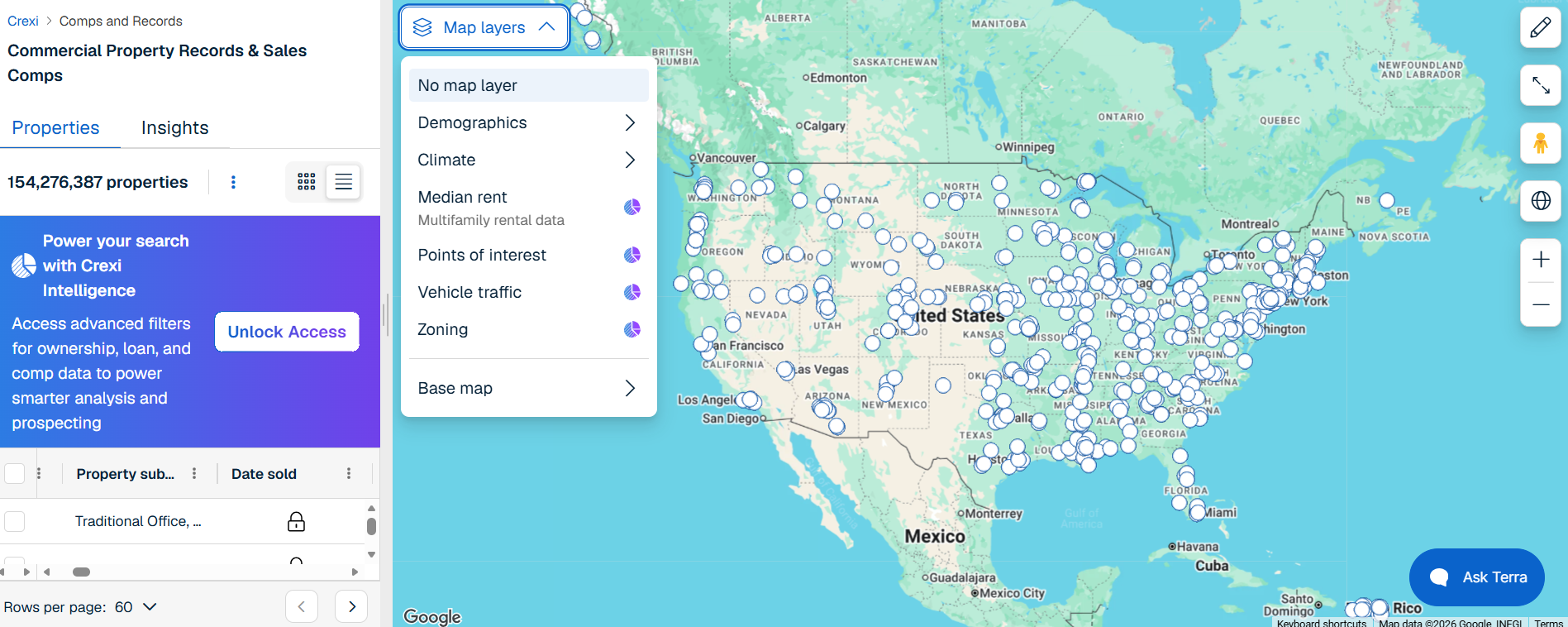
Crexi also publishes a wider set of AI features: Research AI in beta, Crexi Create, Data Enrichment, and CRM sync with Salesforce and Zoho. Its own solutions pages are organized around Deal Closure, Listing Management, Opportunity Prospecting and Valuations & Risk. Every one of those is a transaction job. That is the coherent thing about Crexi: it is built end to end around moving a property from market to close.
Pricing starts at a free tier, which shows the data rows in a locked state so you can see what exists before paying. The Select plan runs $299 per month, with a lower rate on annual billing and higher tiers quoted on request.
What ArchiWise is built around
ArchiWise starts somewhere else entirely. Not with a property, but with a brief.
Most parcels worth developing are not for sale, which is a harder problem than it sounds – our piece on why off-market deals stay off-market covers why that inventory is so difficult to reach by conventional means. So the product is built around a different first move: describe the kind of land you want, then search the market for parcels that match, whether or not anyone is selling and whether or not you know the address.
Everything else in the platform exists to support that sequence.
Site selection: defining where to look
The search starts with how you draw the area, and there are four ways to do it.
Viewport screens whatever is on screen. Draw takes a custom polygon. Location takes a named place. Proximity builds the area around an address, either as a plain radius or as a travel-time isochrone – walking or driving, set in minutes.
Each area can be set to Include or Exclude. That combination matters more than it sounds: you can screen a corridor while carving out the stretch your team already worked, or search a ten-minute walk from a station while excluding the two blocks you have ruled out.
A ten-minute walk is not an estimate you sketch on a map and hope is close. It is the search area itself, and only parcels inside it come back.
Filtering a market against an acquisition brief
Once the area is set, the filters do the work. They fall into groups that map closely onto how an acquisition brief is actually written:
- Parcel details – lot size, frontage, corner parcels only, year built, vacancy, USPS vacancy, lot position, and traffic volume in vehicles per day
- Zoning – by zoning code including compound codes, by land use, or by zoning type
- Ownership – a government-owned toggle plus ownership-type codes spanning private persons, trusts, businesses and government at federal, state, county and city level
- Current use and value – land value, improvement value, last sale price
- Demographics – median household income, population density, homeownership rate and others
- Hazards – flood hazard on parcel and mapped wetlands, each set to Any, None or minimal, or None, screened against FEMA’s National Flood Hazard Layer
Combined, those answer a question a listings search cannot: corner parcels over 12,000 square feet, zoned for multi-family, outside a mapped flood hazard, not government-owned, within a ten-minute walk of this station. No address required, and no requirement that anyone has decided to sell.
Results come back as a live parcel count and a Parcel List you can export as CSV or add to a project. ArchiWise AI will also apply filters across a market from a plain-language request and return the resulting count, citing the code section behind any figure it gives.
Instead of starting with a property someone else selected, you describe the land you want and search the market for parcels that match. The five-step guide to finding land with AI walks that sequence in full.
What the zoning actually tells you
A shortlist is only useful if you can size what fits on it.
Open a parcel and the Zoning tab decodes the designation into its parts, lists permitted, conditional and prohibited uses, and resolves permissions into answers: single-family, two-family, multi-family, commercial, industrial and ADU, each returned as permitted or not. Underneath sit the dimensional standards – maximum FAR, height, lot coverage, setbacks, density and maximum stories – with a link to the governing code.
Since June 2026 both platforms will tell you what a parcel permits, and both will answer a plain-language zoning question with a citation. That is a genuine overlap, and a recent one.
What is published about Crexi’s integration covers classifications, permitted uses and parcel boundaries. Development standards are not named among them.
The distinction matters more than it sounds. Permitted use tells you a multi-family building is allowed on the site. FAR, height, setbacks, lot coverage and density tell you how many units actually fit – and that number, not the permission, is what decides whether the land is worth what the owner wants for it.
For a broker confirming a use is allowed, permitted use is the whole answer. For a developer sizing a building, it is the first half.
Ownership: who to call, and whether they might answer
Neither platform is limited to what is listed, and this is where they come closest.
Crexi holds property records far beyond its active listings, and on a Pro or Intelligence plan you can open a record and reach the owner. For a broker or an investor hunting existing assets, that is a direct route.
ArchiWise’s Ownership tab covers similar ground and adds signals aimed at the acquisition question: owner name and type, mailing address, occupancy, last sale, linked properties, portfolio value, linked debt, portfolio equity, hold period, and a Sell Candidate rating from Weak to Very Strong. The Signals tab layers on distress and verification data from county and postal records – pre-foreclosure, short sale, bankruptcy, pre-probate, tax delinquency, lien counts and amounts, LTV, absentee status, and USPS vacancy with the date it was checked.
The order is what changes. These signals get applied to parcels that already passed a buildability screen, rather than to whatever happens to be in front of you.
The research layer underneath
Once a parcel is worth a closer look, the record opens into thirteen tabs: Property, Zoning, Ownership, Sales, Financing, Taxes, Permits, Listings, Comps, Hazards, Signals, Area and Incentives.
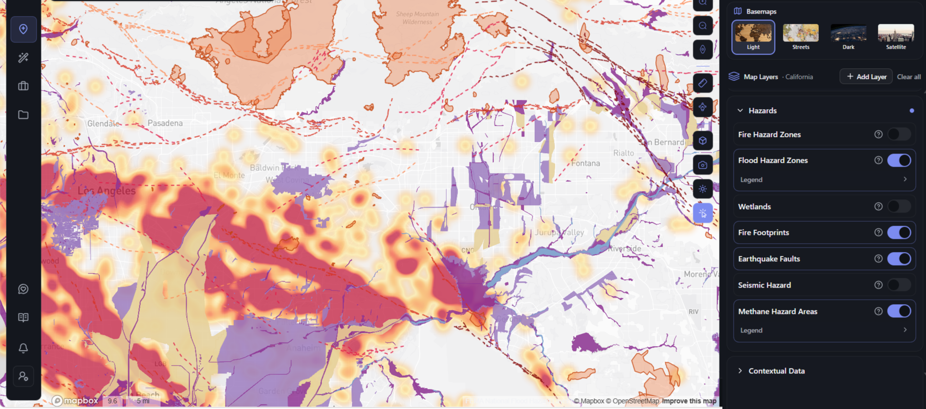
The Hazards tab rates flood, fire severity, seismic shaking, methane, fault proximity and wildfire history since 2010 as Clear, Moderate or High, with the underlying figures behind an expander. The Incentives tab returns Qualified Census Tract with tract name and GEOID, Difficult Development Area, nearby LIHTC precedents, Qualified Opportunity Zone, and SB 79 transit-oriented development.
The map carries the same picture at market scale:
| Crexi – six layers | ArchiWise – layer groups |
| Demographics: population, median income | Property Data: boundaries, census boundaries, parcels, zoning with a searchable codes index, future land use, postal codes, frontage |
| Climate: flood risk, fire risk | Hazards: fire hazard zones, flood hazard zones, wetlands, fire footprints, earthquake faults, seismic hazard, methane hazard areas |
| Median rent | Housing Incentives: Qualified Census Tract, SB 79 transit-oriented development |
| Points of interest | Infrastructure: gas pipelines with a 660-foot consultation buffer, electricity lines, sewer lines |
| Vehicle traffic | Contextual Data: historic resources national and local, points of interest, data centers, transit stops, terrain contours |
| Zoning, with permitted-use overlays added June 2026 | Demographics |
A marketplace does not need a methane layer or a QCT screen. But if your thesis depends on an incentive, or dies on a hazard, the layer either exists or it does not.
Beyond screening and evaluation, ArchiWise also offers Entitlement Viability and an AI Visualizer. Both sit outside the scope of this comparison, which is about how each platform helps you find and assess a site in the first place.
Side by side
| Crexi | ArchiWise | |
| Primary purpose | Marketing, researching and transacting commercial property | Finding and evaluating parcels to develop |
| Workflow starts with | A property | A set of criteria |
| Listings marketplace | Yes | No |
| Property records | 153M+ commercial property records | Parcel records nationwide |
| Sales comps | Yes | Comps tab |
| Owner identity and contact | Yes, on Pro or Intelligence | Owner name, type and mailing address |
| Ownership and seller signals | Not published in detail | Hold period, linked debt, portfolio equity, Sell Candidate rating, distress and vacancy signals |
| Custom search areas | Not published | Viewport, Draw, Location, Proximity, each Include or Exclude |
| Travel-time search | Not published | Yes, walking or driving |
| Parcel filters | Permitted-use filters, since June 2026 | Parcel details, zoning, ownership type, current use, value, demographics, hazards |
| Hazard filtering | Not published | Flood and wetlands |
| Zoning class and permitted uses | Yes, since June 2026 | Yes |
| Dimensional standards | Not published | FAR, height, lot coverage, setbacks, density, maximum stories |
| Plain-language zoning Q&A with citations | Yes | Yes |
| Housing incentive screening | Not published | QCT, DDA, LIHTC, QOZ, SB 79 |
| Infrastructure layers | Not published | Gas, electricity, sewer |
| Tenant rosters | Yes | No |
| Projects and pipeline | Deal and listing management | Projects |
“Not published” means the capability does not appear in that platform’s published material as of October 2026. It is not a statement that the capability is absent. Several features on both sides are plan-dependent.
What Crexi does that ArchiWise doesn’t attempt
ArchiWise has no marketplace. There are no listings to market, no listing distribution and no inventory of properties for sale. If part of your job is representing or marketing assets, Crexi does things ArchiWise does not try to do.
Crexi’s tenant rosters are also outside what ArchiWise covers. For anyone underwriting an occupied commercial building, knowing the tenant mix and tenure is central, and that is Crexi’s ground.
Where ArchiWise stops
Coverage is three separate things, and they are not interchangeable. Parcel data is nationwide. Individual map layers vary by market, so check the one your decision rests on before you rely on it. AI code interpretation is jurisdiction by jurisdiction and expanding, with California furthest along.
Large search areas return roughly 100 parcels, and the interface does not say so. Treat a wide screen as a sample, not a census.
Hazard filtering is narrower than hazard display. You can filter on flood and wetlands. Seismic, methane, fault proximity and wildfire history appear as map layers and per-parcel ratings, not as search filters.
Which one fits your work
This is not a ranking. The two answer different questions.
If you are transacting on existing commercial assets – marketing listings, running comps, valuing a building, reading a tenant roster, managing a pipeline to close – Crexi is built for that end to end.
If you are acquiring land to develop – defining criteria and screening a market against them, sizing what fits inside the envelope, checking hazard and incentive exposure before an offer, and reaching owners who never listed – that is the work ArchiWise is shaped around. The step-by-step comparison against manual parcel screening shows what that replaces.
Plenty of teams will use both, and that is a reasonable answer rather than a diplomatic one. They sit at different points in the same deal.
Limitations worth naming
Solvable, because they are information problems. Finding candidate parcels without an address. Screening a market against development criteria. Surfacing hazards, overlays and incentive eligibility before an offer rather than during due diligence. That is data that exists and is badly distributed, which is what software is for.
Not solvable by software. Capital costs. Construction costs. Entitlement politics. How long a planning department takes. No platform moves those, and anyone implying otherwise is selling something.
Zoning data informs a development strategy. It does not replace entitlement counsel, a civil engineer or an attorney, and neither platform claims otherwise.
Getting to a shortlist of parcels you chose, instead of researching the ones that arrived, is the part of acquisition most worth speeding up. A willing seller on a parcel you cannot build on is not a deal, it is a distraction.
If that is the part of your process you would like to change, see how ArchiWise works and what it costs.